
|
|
Mountain/Rock |
|---|---|
|
|
40.79290°N / 110.3666°W |
|
|
13103 ft / 3994 m |
|
|
Overview
West Gunsight Peak is another one of Utah’s 13’ers. I would rate it as the second easiest of the 13’ers, after Kings Peak. The peak is always viewed by those climbing Kings Peak, but until recently, was seldom climbed. With more interest in peak-bagging and peak list, the Utah 13’ers are slowly becoming more popular. Like most of the peaks in the Uinta Mountains, this one too is un-named. The West Gunsight name first appeared in the book Utah Mountaineering Guide, 2nd edition in 1986. A new guidebook Utah 13’ers came out in 2004 and labels this as Dome Peak. Since the West Gunsight name is older, this is the name that will be used on this page. Both names are applicable since the peak forms the west side of the “gunsight” on Gunsight Pass and the peak looks like a dome.The Uinta Mountains are one of the few mountain ranges in North America that run east to west rather than north to south. Within the Uinta Mountains are about 2000 lakes, and some 900-1000 are full of trout. Along with the San Juans in Colorado, the Uintas have more contiguous area above timberline than any other area in the Continental United States. This is a beautiful area with many lakes, meadows, wildflowers, and some rugged peaks. Solitude is usually easy to come by once you leave the popular fishing holes behind.
One thing that makes Utah's 13'ers different, then say the Colorado 14'ers, is that the distances from the nearest roads are usually much greater for the Utah 13'ers. West Gunsight is actually one of the closer 13’ers in Utah to a trailhead, but is still about a 30 mile round trip hike from the standard route (Henry’s Fork to Anderson Pass).
Utah's 12,000+ Foot Peaks With 200+ Feet Prominence
Utah's 12,000+ Foot Peaks With 300+ Feet Prominence
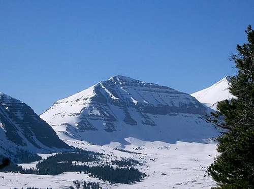 West Gunsight Pk, 5/22/05 from the north.
Getting There
Henrys Fork TrailheadThere are several possible routes to West Gunsight Peak, but by far the most popular route is from Henry's Fork. From exit 39 on I-80 head South towards Mountain View on route 414 for 6 miles. At the “Y” (@ the Bronze Elk) stay right on route 410 heading towards Robertson at about 6.8 miles on 410 the road makes a 90 degree right hand turn, at this point you will want to go straight (or left) leaving 410. The road turns and stays gravel for the duration of the drive to the trailhead. Continue straight on the gravel road after leaving 410 for 12.3± to another intersection at this point turn left, right would take you to China Meadows (7 miles). After taking the left continue for 7.7± miles to a hairpin turn, at this point continue straight (or right) off of the previous road. Follow this for 3 miles to the Henry’s Fork Trail head. The last 3 miles of the road are not maintained in the winter months, so your temporary trailhead will start 3 miles sooner.
West Fork Whiterocks Trailhead
There are several driving routes to the trailhead, but this is the quickest. A good road map is needed. From Roosevelt, take State Highway 121 north. This is where the elbow in Highway 40 is, right downtown, so the turnoff is easy to locate. Stay on Highway 121 north, follow it as is makes a sharp turn at Neola and heads due east. The highway will reach a "T" and turn south. At the "T", turn left (north) to the town of Whiterocks. From Whiterocks, drive northwest along the paved road. Not long after passing the fish hatchery, will be another junction. Go straight (not left). The road heads north, then east, then north again. At the next intersection, go straight and to the Elkhorn Guard Station. Continue straigh on the Elkhorn Loop Road, up Pole Mountain, and to Forest Road 110 before heading to Pole Creek Lake. Don't take the Elkhorn Loop to Pole Creek Lake, but turn right onto Forest Road 110. If you reach Pole Creek Lake, you overshot the turnoff. Follow Forest Road 110 north for about four miles to the signed (for West Fork Whiterocks Trailhead) turnoff to the left. Instead of turning left, turn right and drive about eight miles to the trailhead below Chepeta Lake. Most of the Elkhorn Loop as well as Forest Road 110 is gravel, but usually in good condition for cars, provided you drive slowly.
Highline Trailhead
Same as above, but instead of turning left at the last junction, turn right and drive about eight miles to the trailhead below Chepeta Lake. Most of the Elkhorn Loop as well as Forest Road 110 is gravel, but usually in good condition for cars, provided you drive slowly.
Uinta River Trailhead
Note: These directions were updated as of November 2009 by SP member ZeeJay:
From the intersection of Highway 121 and Highway 40 in the town of Roosevelt in the Uinta Basin, drive west on 200 North (Highway 121). Stay on Highway 121 as it quickly bends to the north. Most junctions are marked with signs, but they are very hard to read in the dark. At mile 9.9, just after the actual mile marker 10 at a stop sign, at the hamlet of Neola go straight towards Uintah Canyon. At mile 16.7 continue straight. At mile 18, turn right to Uintah Canyon. At mile 21.9 turn right. At mile 22.2 turn left just after the bridge. Park at the trailhead at mile 25.6.
Swift Creek/Yellowstone Creek Trailhead
First drive to the town of Duchene, which is along US Highway 40. From Duchene, turn north onto State Highway 87. Follow State Highway 87 until it joins with State Highway 134 (this is where state Highway 87 heads due east instead of continuing north) between milepost 15 and 16. Follow State Highway 134 north to the little town of Mountain Home. Where State Highway 134 begins to head due east at Mountain Home, Continue north on the Moon Lake Road. After five miles, turn east on the Yellowstone River Road and to the Yellowstone River Power Plant. Continue along the Yellowstone River road to the trailhead at the end of the road, passing the Yellowstone River Dude Ranch and two campgrounds along the way.
 From Henrys Fork. Gunsight Peak (left) and West Gunsight (right).
Routes Overview
There are many routes available to climb West Gunsight Peak from all directions. For the sake of the page, most of the routes from each direction will all share the final mile from Anderson Pass together. Anderson Pass is by far the easiest route to complete the final mile to the peak. I came down the southeast face, but this has many more boulders and is more difficult. If coming from the north or east, a route directly up from Gunsight Pass would certainly be possible, but that side of the mountain has much boulder-hopping as well. See the Route Page. It looks like a fun route, but if you want an easier climb, I would recommend going to the Anderson Pass area to make the final climb.The north side of West Gunsight appears to have some nice snow couloirs before late July, but cliff bands would be an obstacle on many of them. If you do climb any, make sure to post some information!
Some people use the chute north of Anderson Pass as an ascent/descent route into the area, but I do not recommend it, at least after the snow melts. It is loose and rolling rocks knocked down by other hikers are a concern. The route is not environmentally friendly and causes erosion. If you do choose this route, please do so before mid-or late July when the route is covered with snow!
These are meant to be overviews only. For much more detail, see the route pages.
Henrys Fork Route
The most popular route is from the north and Henry's Fork, Dollar Lake, over Gunsight Pass, Painter Basin, to near Anderson Pass, and then to the summit. This route is about 30 miles round trip and usually takes three days. It is a beautiful route, but also the most crowded.
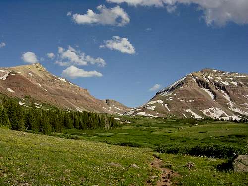
 Fox-Qwent Pass on the West Fork Whiterocks Route.
West Fork Whiterocks Route
The West Fork Whiterocks River route is another longer route (49 miles round trip) and usually takes five days. The route goes over Fox Quent Pass, follows the Highline Trail to Painter Basin, to Anderson Pass, and south over Kings and finally to South Kings. It is a scenic route, with lots of huge flower meadows and several large lakes.
 Kidney Lakes on the Highline Trail.
Highline Trail
Another possible route is from the 70-mile long east-west Highline Trail. You could begin this hike all the way from Hayden Pass on the west, but the shortest route is from the east and Chepeta Lake. This route joins with the West Fork Whiterocks Route (see above) at Fox Lake.
 Cairn on top of West Gunsight/Dome Peak.
Uinta River Route
The Uinta River Route is another southern route. It is highly scenic and has large lakes and meadows. It goes up the UInta River, over to Chain Lakes, Atwood Lake, Painter Basin, to near Anderson Pass, and to the summit. It is a long route (48 miles), highly scenic, and usually takes 4-5 days.
 West Gunsight Peak/Dome Peak. Anderson Pass to the left, Gunsight pass to the right/below. September 13, 2003
Swift Creek/Yellowstone Creek Route
The Swift Creek Route is a southern route and offers a viable alternative that is less crowded and not that much longer than the standard route. It is recommended you take the highly scenic alternate route over Bluebell Pass, Milk Lake, and to Anderson Pass. This includes many miles of off-trail travel, but the going isn't that tough and the scenery is fantastic. The route is about 40 miles round trip and usually takes four days.
 Left to right: Gilbert Peak, West Gunsight, Kings, and Henrys Fork Peak as viewed from the north and Henrys Fork Basin. July 1987. Many good campsites are in the area.
Red Tape
No permits are required. Normal wilderness rules apply.When To Climb
The normal summer season is July through September. Mosquitos are very thick in July. The Henry's Fork trailhead is usually open from May until sometime in October or early November. Between those two dates, the road is closed 3 to 3.5 miles from the trailhead.In winter, West Gunsight is usually is 4-day climb via Henrys Fork. Climbing the Uintas are rather unique in winter because the most difficult part of the trip is actually covering the realitively flat ground to get to the mountain's base. This is because of typically very powdery snow below treeline. Usually, once you reach the steeper parts of the mountains; the parts above timberline, the going actually gets easier because the snow is blown rock-hard. Here is a mid-winter trip report of an experience in the Henrys Fork Basin, and it will give you an idea of what type of conditions to expect.
Henrys Fork is the only practical trailhead for a winter ascent as all the other trailheads have winter road closures far from the trailheads. You're looking at 70 miles or more round trip, via other routes to climb to the summit and back!
Camping
There is camping at the trailhead (Henry's Fork Campground) and plenty of good campsites all the way to Dollar Lake. Dollar Lake is a very heavily used campsite, so I would recommend camping elsewhere in summer.[img:127469:aligncenter:medium:Left to right: Gilbert Peak, West Gunsight, Kings, and Henrys Fork Peak as viewed from the north and Henrys Fork Basin. July 1987. Many good campsites are in the area.]
Mountain Conditions
Information regarding the conditions for climbing in the West Gunsight Peak area can be obtained from Wasatch-Cache National Forest, 8236 Federal Bldg., 125 S. State Street, Salt Lake City, UT 84128, (801)524-3900. Click here for additional information.Weather Forecast for Central Uinta Mountains
Here are some average highs and lows from the 13,123 foot elevation (4000 meters) in the Uintas (about the same altitude as the summit):
| MONTH | HIGH | LOW |
| JAN | 11 | -4 |
| FEB | 13 | -2 |
| MAR | 16 | 1 |
| APR | 24 | 8 |
| MAY | 32 | 15 |
| JUN | 42 | 22 |
| JUL | 52 | 29 |
| AUG | 50 | 28 |
| SEP | 42 | 21 |
| OCT | 31 | 12 |
| NOV | 19 | 5 |