
|
|
Mountain/Rock |
|---|---|
|
|
39.74253°N / 106.27945°W |
|
|
Summit |
|
|
Hiking |
|
|
Summer |
|
|
13213 ft / 4027 m |
|
|
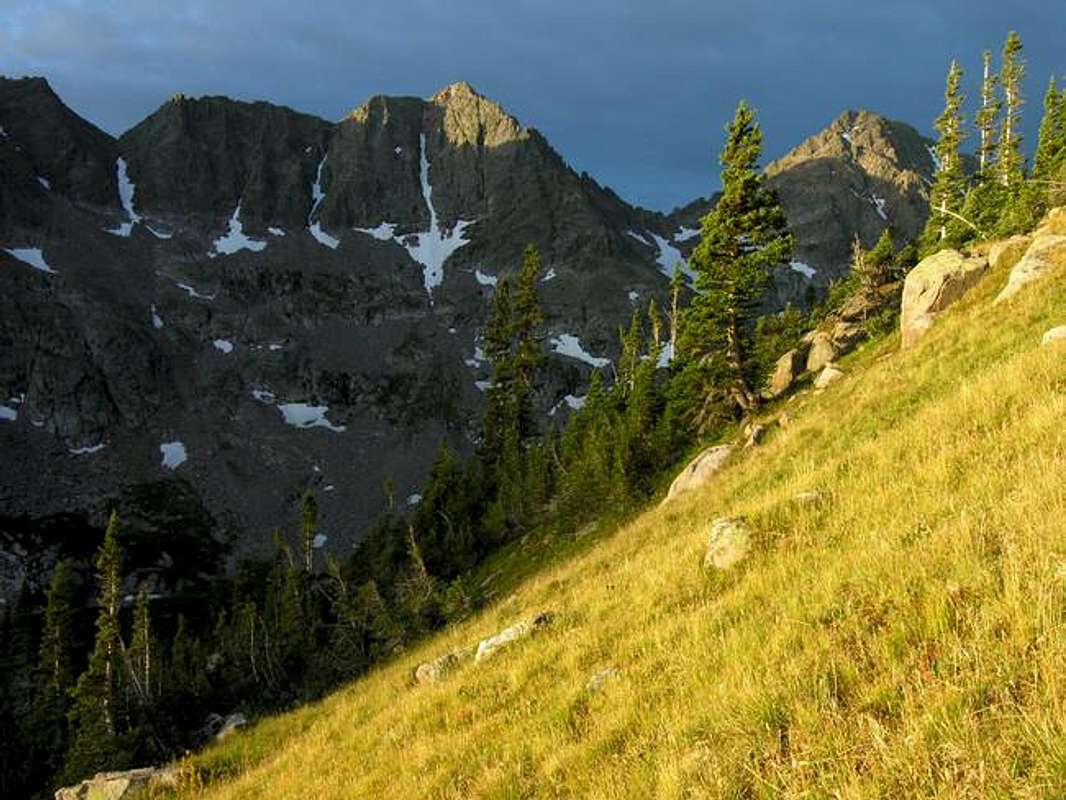
Gore Range Overview
”In my opinion, the two most rugged mountain ranges in Colorado are the Gore Range northwest of Dillon Reservoir and the Needles Range in the remote San Juan Mountains.” -John Fielder-famous Colorado Landscape photographer. The Gores are more of a range consisting of 12-13,000-ft ridges, rather than separated peaks. A few of the more prominent ridges actually have names like, Zodiac Spires, Rockinghorse Ridge, Ripsaw Ridge and the Grand Traverse. With 50 peaks over 12,000-ft, none attain the magic 14,000-ft mark, which is the primary reason for the Gores obscurity. This is one of Colorado’ most rugged mountain ranges and the rock quality is generally good. Only 60 miles from Denver, Colorado the Gore Range as a whole is relatively inaccessible due to the lack of mining roads that normally criss-cross other Colorado mountain ranges. The Gores also have a reputation for a lot of trailhead access red tape, due in large part to private property. Hikers and climbers not interested in long approaches and heavy vertical might want to look elsewhere for their adventure. Overall, the west side of the Gore Range is more accessible than the east. Approaches that start from the east are few because of private property, in return, expect even longer approaches and expect a poor network of trail systems. Precise planning and execution are of paramount importance when selecting routes in this range. Armed with a loaded backpack and good maps, many of these quiet summits can be climbed without a rope. Major faces and long jagged ridges provide unlimited technical climbing opportunities as well. An ice axe is highly recommended on any early season climbs. Officially named peaks in the Gore Range are hard to come by, only a few of the Gore highpoints have official names. Differentiating the highpoints on a map or while hiking has challenged all of us at some point. Thankfully we have the CMC to make sense of all of that rugged terrain. In 1932, CMC members Carl Erickson and Edmund Cooper used letters to assign summits in the obscure Black Creek Basin and the CMC subsequently tended and expanded the system (Jacobs & Ormes- Guide to Colorado Mountains.) The lettering system for naming peaks has frustrated many casual visitors over the years, however Gore Range enthusiasts seem to embrace the system. It won’t be going away anytime soon.
My Pledge
In the spirit of exploration, my SP pages representing the eastern peaks of the Gore Range will intentionally leave you with some homework to do. My route descriptions will be in guidebook form and might seem vague. I will not submit a topographic map. However, I will give you the standard route beta you need to climb the peaks. If you need a topo, e-mail me and I will be happy to send one your way. I spent 2 years meticulously studying updated area TOPO maps. I climbed 22 peaks residing on the western aspect of the range before adventuring the east. During that span I was very fortunate; I lucked out in locating the right people willing to share route beta for these peaks. I intend to honor the idea of keeping the eastern peaks as pristine as possible for those who are willing to put in the time researching the area. My forthcoming pages and route description should be used in harmony with a good map.
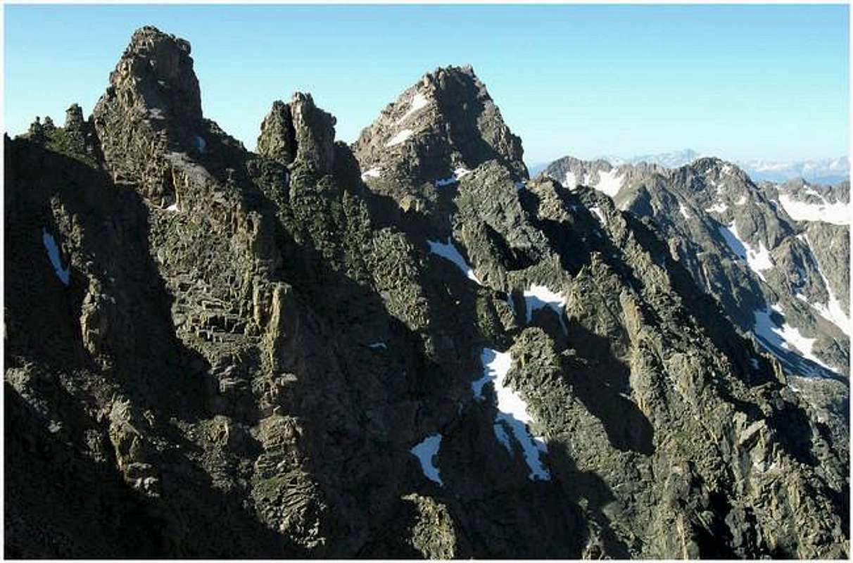
Peak L or "Necklace Peak" Overview
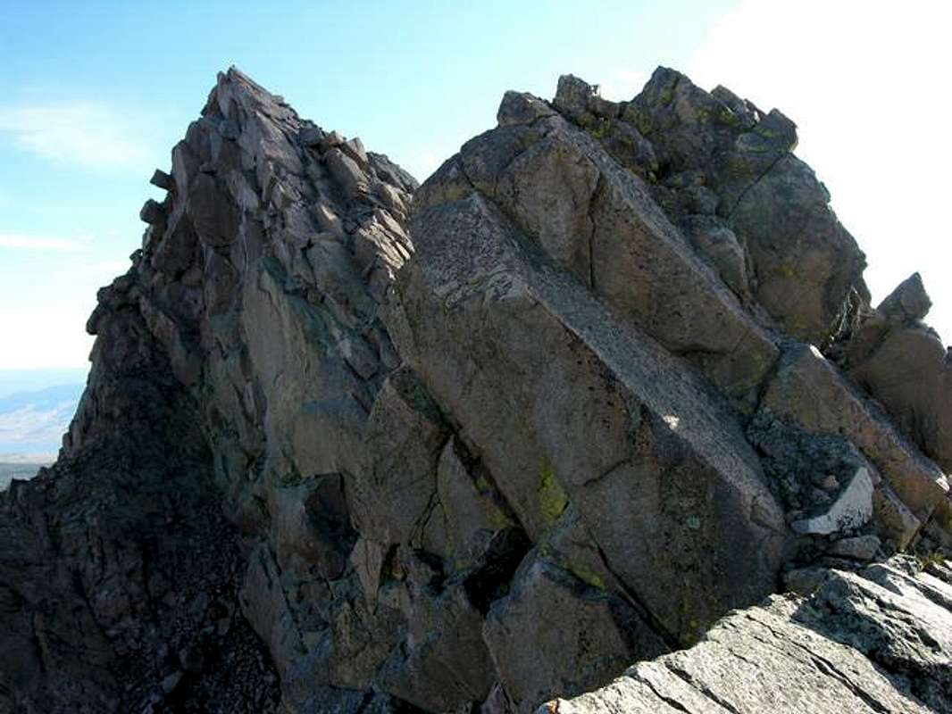
In all my years of climbing Colorado mountains, no other peak has commanded my attention like Peak L. I feel comfortable speaking for all Gore enthusiasts; Peak L or “Necklace Peak” is the most alluring and recognizable mountain in the entire Gore Range. By its standard route, Peak L is the most technical 13er in the range, requiring an airy “Capitol-like” knife-edge traverse, and exposed class 4 climbing. The rock is bomber proof. From other summits, Peak L’s unique charisma/symmetry gracefully floats along a jagged skyline, completely uninhibited by other big peaks. It is the watchtower and lookout for all of the central Gore Range. Without a doubt, Peak L is a true sentinel. Peak L’s tiny 13,213-ft summit (ranking #8) provides unique vantages for all of the area superstars. The mountain resides about 2 miles northeast of the main spine of the mountain range, taking on somewhat of an “outpost” mentality. Only Peak Z (13,245-ft) delivers more elevation that far away from the main backbone of the Gore Range. Big mountains like Peak Q, Peak R & S, Peak M, The Ripsaw and Mount Powell all show like trophy peaks from Peak L. Peak L is an obscure and distant mountain, requiring almost 21 miles round trip to reach the summit. Going forward from Upper Slate Lake, expect “Gore” bushwhacking. Remember “Gore” bushwhacking is different and more miserable than typical Colorado bushwhacking. This mountain is not for the squeamish or inexperienced. Expect airy exposure with a significant “pucker factor.”
Getting There
Because of private property issues, access to the east side of the Gore Range and to the Gore Range Trail is limited. There are three potential trailheads for this climb. All three will get you to the Gore Range Trail, a trail that runs north/south allowing access to the different drainages located on the eastern side of the Gores. The following RT and Vertical Gain statistics are for the approach to Upper Slate Lake only. Most climbers like the public accessible Brush Creek TH (9,050-ft) and some like the Rock Creek TH (9,490-ft.) I will describe the lesser known of the three, the Boulder Creek TH (9,470-ft.) This one requires a bike ride, but it will save you 3 miles RT and 650-ft over the Rock Creek TH, and 2 miles and 400-ft from over Brush Creek TH. BTW, you need a 4-wheel drive to get to the Brush Creek TH. I will add directions to the Brush Creek TH in time. The Boulder Creek TH is located on private property, however the owners allow access to the Boulder Creek Trail from the trailhead. Here is the kicker; you cannot park at the trailhead. This is where a bicycle comes in handy. From I-70, exit CO 9 at Silverthorne and drive 9.1 miles and exit left on Boulder Creek Road. Locate the public parking area at the junction of both roads, it is signed. Boulder Creek Road is an improved dirt road; there is no need for high clearance. Drive 1.7 miles to the end of the road where it is fenced off and there is a private residence on the left. Unload your climbing companions and gear. There is no sign for the Boulder Creek TH. Return 1.7 miles to the parking area and bike back to your climbing buddies. This should take around 30-40 minutes.
Eagles Nest Wilderness-Red Tape
See Getting There “Red Tape” per attm No permits or fees are required. Like all wilderness areas no mechanized or motorized vehicles are permitted within the Eagles Nest boundaries. Wilderness is land set aside as part of wild America, where man can be a visitor. The natural environment has not been disturbed. Travel is restricted to foot or horseback. No mechanized equipment is allowed. For more information, contact the U.S. Forest Service at the # below: Additional Resources: Eastern Portion of the Wilderness: Dillon Ranger District 680 River Parkway Silverthorne, CO 80498 970-468-5400 or Western Portion of the Wilderness: Holy Cross Ranger District P.O. Box 190, 24747 US HWY 24 Minturn, CO, 81645, Phone: 970-827-5715
Conditions
- Colorado Avalanche Information Center (CAIC)
- Vail Web Cam
Click image to enlarge
Click here to view a 7-day forecast Slate Creek Drainage at 11,400-ft
