
-
 21260 Hits
-
 80.33% Score
-
 12 Votes
|
|
Mountain/Rock |
|---|---|
|
|
39.22340°N / 105.6642°W |
|
|
9677 ft / 2950 m |
|
|
Overview
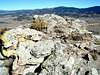
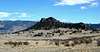
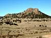
Eagle Rock, while only 9,677 feet in elevation, rises over 500' above the surrounding terrain and offers great views of the Retirement Range area. The Retirement Range is comprised of four groups of mountains: The Platte River Mountains, the Kenosha Mountains, the Tarryall Mountains and the Puma Hills. Eagle Rock is in the northwest area of the Puma Hills and is located in Pike National Forest just west of Tarryall Creek and the Lost Creek Wilderness.
The southwest ridge route is about one mile roundtrip with just over 500 feet of gain and is a fairly straight forward Class 2 scramble. The north ridge is just over one mile roundtrip with just over 700 feet of gain and is a little more difficult so is rated Class 2+.
The rock is not often climbed so you are likely to have the route and the summit all to yourself.
Eagle Rock is well covered in Gerry and Jennifer Roach's "Colorados's Lost Creek Wilderness - Classic Summit Hikes".
 |  |  |  |  |
Getting There
The Trails Illustrated Map #105 – Tarryall Mts. / Kenosha Pass would be very helpful in finding the trailhead and identifying surrounding peaks upon summiting.
FROM THE NORTH (DENVER):
Head west on US 285 passing over Kenosha Pass. Just over 4 miles west of the Pass turn south (left) on Park County 77 in the small community of Jefferson. Continue south on 77 until you come to the Tarryall Reservoir. Just south of the reservoir, turn right onto Forest Service Road (FSR) 23.
FROM THE SOUTH (COLORADO SPRINGS):
Head west on US 24 to the small community of Lake George. Shortly after crossing a young South Platte River, turn north (right) on Park County 77. Continue north on 77 until you come to the Tarryall Reservoir. Just south of the reservoir, turn left onto Forest Service Road (FSR) 23.
FSR 23 is passable to most vehicles although a high clearance vehicle would be best. After a few miles you will veer right onto FSR 146. Follow FSR 146 pass the south side of Eagle Rock. You will come to a ninety degree turn with a left turn that will leave Pike National Forest. This is the trailhead for the north ridge route. Continue straight for about a half mile to a faint road on the right that appears to head around Eagle Rock. Turn right and park here. This is the trailhead for the southwest ridge route.
 |
Red Tape
The entire route is located in the Pike National Forest and requires no permits.
When To Climb
The access roads may not be passable in winter or after a heavy spring snow – check with the Forest Service.
Camping
There are several Forest Service Campgrounds located along Park County 77. To the south is the Spruce Grove and Twin Eagles Campgrounds. Packer Gulch Campground is located at Tarryall Reservoir along FSR 23.
Mountain Conditions
Check local weather here.