
|
|
Mountain/Rock |
|---|---|
|
|
46.81350°N / 121.529°W |
|
|
5834 ft / 1778 m |
|
|
This page is up for adoption
I have decided to open up my Washington State pages for adoption to those who have been to the summit of the mountain and have a interest in maintaining and updating the page. Contact me via messenger if you are interested.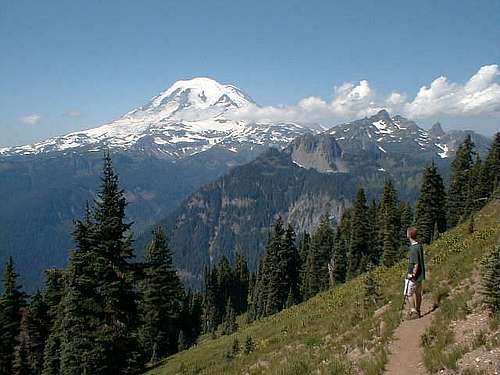 Mt. Rainier from the Shriner Peak trail, just below the lookout
Outstanding trip report 10-1-10 from NWHikers
Overview
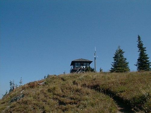
Shriner Peak is one of the most outstanding spots for viewing Mt. Rainier short of being in an airplane. The mountain looms large to the west and on a clear day is awe inspiring. I easily spent a couple hours on the day I visited just staring at the mountain and trying to pick out the climber routes.Shriner Peak is also topped by a lookout, and is within Mt. Rainier National Park. The lookout is representative of a standard National Park Service design of the 1930s, a two-story structure that measures 14 by 14 feet and has a catwalk wrapping the upper deck. It is The oldest of four lookouts remaining in the Park, it has been restored following the original plans. It is still used in critical fire weather. When I was there, a maintainence crew was inside working on it and I was able to visit the inside and get the feel of what it felt like to be the lookout with this magnificient view of Mt. Rainier always out the west windows. I'll provide a section in a day or so that will cover the history of the lookout and hopefully find some better pictures of it. I hate to admit that I can't find all the pics I took but
they are somewhere in cyberspace.
Shriner Peak is accessible by trail and is a walk up. It is a 4.2 mile effort with a gain of almost 3500 feet. I'll put a more descriptive route up which will include a trail map and what you will need to take with you besides a camera.
No camera? Buy or borrow one for this hike but only do it on a day when you can see Mt. Rainier. Otherwise it is a great conditioner.
Getting There
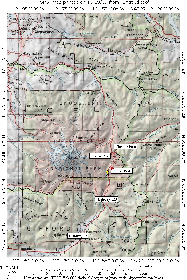
From Seattle, drive Hwy 410 east through Enumclaw and Greenwater to Cayuse Pass. At the pass take Hwy 123 and drive about 6-7 miles south to the trailhead on the east side of the highway. Parking is on the west side of the highway about 100 yards north of the trailhead. Be aware that road construction has been taking place in the area and delays can be expected when approaching the area where you can park for the trailhead. The trailhead is very easy to miss - there's a tiny generic hiking sign on the opposite side of the road, but no sign at the actual trailhead, and nothing indicating the trail leads to Shriner Peak. The parking area on the trailhead side of the road could only accomodate 2-3 cars, but there's additional room on the opposite side of the road. I'd recommend using this GPS coordinate to help when you get close to the TH.If coming from the south on 123, the parking area is 3.5 miles north of the Stevens canyon entrance and 1/2 mile north of the Panther Creek bridge. So, if you are coming in from Cayuse pass and you pass the Panther Creek bridge, you need to turn around and go back that 1/2 mile.
SP member ericnoel noted that "because this trailhead is essentially a pullout on a fairly heavily trafficed road but in a location with limited visibility and no one around much of the time this is probably a place where you are fairly vulnerable to a car breakin. ."
That is good advice. Hide your valuables or take them with you.
I have placed another map which shows the route in the route page.
Red Tape
No parking permit is required to park at the TH nor does entry from the north or south on highway 123 require purchasing entry into the park. This one is a freebie but obey the speed limits in the park. Tickets for speeding are awarded to the lucky few. Of course, conditions do apply that can be considered red tape.Should you want to camp near Shriner Peak, a backcountry wilderness permit is needed. No firearms and pets are not allowed on park trails. No picking of flowers permitted but huckleberries are plentiful and o.k. to gorge on when autumn rolls around. The bears love em too as plentiful bear scat indicates.
When To Climb
As long as road 123 is open, this one can be hiked. Snowshoes are helpful in early season when snow lingers higher up. No need for a rope or special climbing gear since this one is reached by a trail that can generally be accessed from early may to when the snow closes highway 123. Check with the NPS via this LINKCamping
Ohanapecosh is just a few miles to the south and the Forest Service campground La Wis Wis in four miles beyond Ohanepecosh as you go towards Packwood.Ohanapecosh is an outstanding campground, my favorite in all of Washington if I go car camping. Most campsites are by reservation only but at the moment, they have some first come, first served campsites in the "G" and "H" loops. Generally no reservations are needed prior to Memorial Day or after the Labor day weekend.
Mountain Conditions
Check out this page for sources on the weather. Click here.More specific information is found HERE
A snow report on the local ski area, Crystal mountain is available HERE.
Lookout information
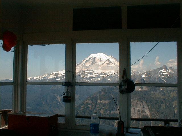
This is a lookout that is sometimes open to the public during the summer. If you are lucky to be able to go inside, you will get a feel for how it felt tobe the lookout who had one of the best viewpoints for Mt. Rainier that there is.
The view from inside the lookout
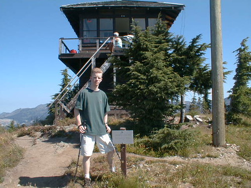
My son in front of the lookout and the guy sitting on the steps in the background was a fellow from Germany. He was awed by Mt. Rainier.
Trip reports posted at NWHikers.net
As you will note from the many trip reports I have made links to, NWHikers.net is a group who truly loves to hike the local mountains.Please take the time to check these reports out and you will be rewarded with not only good trip reports, but some really nice pictures.
The latest is from July 2009: HERE
Two really nice trip reports with some great pics from Sept 2008
Sept 2008 TR
Sept 2008 TR #2
From early summer 2008, (snow included)
Nice TR.
Previous TR's:
Some nice pics of an October (2007) trip posted in this trip report (NWHikers.net) by Trail Pair.
Click HERE to see this TR & pics.
Check out this trip report filed on
NWHikers in 2007 (worth a look)
Fall 2006 TRIP REPORT posted on NWHikers.net Worth a look for the fall colors