
|
|
Mountain/Rock |
|---|---|
|
|
49.11900°N / 20.12400°E |
|
|
8612 ft / 2625 m |
|
|
Overview
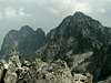
Pyšný Štit / Durny Szczyt is the one of the highest summit in High Tatra, exactly the 5th and the one of the most “honorary” because of its height, impressive appearance and ascend’s difficulty. It never goes on a top a marked or artificially insured trail. For that reason Pyšný Štit is rather rarely visited, but wrongly – the view from a summit is really imposing!

Massif of Pysny Stit seen from the south-east ridge of Baranie Rohy
It is situated in a long lateral ridge of High Tatra, which begins on Vyšná Barania Strážnica / Wyżni Barani Zwornik and runs through Baranié Rohy / Baranie Rogi, Pyšný Štit / Durny Szczyt to Lomnický Štit / Łomnica between Vel’ká Zmrzla / Dzika Valley on the north-east and Piatich Spišských Plies / Pięciu Sawów Spiskich Valley on the south-west.
The massif of Pyšný Štit contains except this one (from north-west to south-east) Spišský Štit / Spiska Grzęda, Ovčiarska Veža / Juhaska Turnia, Vetrený Štit / Pięciostawiańska Turnia, Supia Veža / Sępia Turnia, Strapatá Veža / Czubata Turnia and Malý Pyšný Štit / Mały Durny Szczyt.
The massif of Pyšný Štit is separated from Baranié Rohy / Baranie Rogi through Baranié Sedlo / Barania Przełęcz (north-west) and from Lomnický Štit / Łomnica through Bachledová Štrbina / Klimkowa Przełęcz (south-east). The itself Pyšný Štit is separated from Malý Pyšný Štit by Lastovičia Štrbina / Durna Przełęcz in which stick up Loktibrada / Durna Igła – characteristic crag in a form of needle.
The Slovakian and Polish name comes from a highlander dialect and means “proud” because of its precipitous and towering shape. But in modern Polish language a word “durny” means “stupid”. Sometimes a history is pawky :).
 |  |  |  |  |
First ascend
in summer: Ödön Téry with guide Martin Spitzkopf in 1877
in winter: Ede Hruby, Oszkar Jordan, Roman Komarnicki, Jeno Serenyi 1910
 |  |
Getting There
From Slovakian side:
The major city in this area is Poprad, where you can get by bus or train. From Poprad there is a lot of buses and trains to Stary Smokovec (13km) at the foot of Tatra:
train time table
bus time table
train time table from Poprad to Stary Smokovec (Tatranská elektrická železnica)
Maps of Stary Smokovec and Tatransca Lomnica
From Polish side:
The best point to stars the journey is Zakopane – the biggest town on Polish side of Tatra Mountains.
Take a bus to Polana Palenica (time table of PKS, in high season there are a lot of private buses, too – a station is opposite to PKS) and get off in Lysa Polana. Cross the polish-slovakian border . Bus station on Slovakian side is about 100m after border crossing point on the right. Take bus to Poprad, which goes through Tatranska Lomnica and Stary Smokovec (time table).
In mountain:
Approach to Chata pri Zelenom Plese:
Take a bus from Stary Smokovec to Lysa Pol’ana and get off in Bela Voda. There is only a little parking-place among a forest and beginning of yellow marked trail, leading to Chata pri Zelenom Plese (about 2 h 45 min).
Approach to Teryho Chata:
From Stary Smokovec follow green marked trail to Hrebienok / Siodelko (you can take there cable railway (“lanovka”) – (time table ) – 1 h 15 min. Next follow red marked trail in Skalnata Chata direction and after about 45 min turn left on green marked trail, leading to Teryho Chata (2 h).
Maps

Map of Pysny Stit' area
Tatry Wysokie, in scale 1:25 000, description in 6 languages, ISBN 83-87873-26-8, available in all shops in Zakopane. Here you can look at net version.
A high quality maps in scales 1:25 000 and 1:50 000 are produced VKU Harmanec, too. They are available at all chalets and shops in cities under Vysoke Tatry.
When To Climb
The best time is a summer and early autumn (july-september).
Red Tape
The “High Tatra” is a National park, UN Bioheritage area and a European BioHeritage - if you are not a member of any climbing club you can move only on marked trails - so you can visit Pyšný Štit only with tatra guide.
In winter time (from November the 1st – June the 15th) The Tatra Mountains in slovakian part are closed for normal tourists (not for climbers). In Polish part you can move the whole of year.
For more informations look at High Tatra/Vysoke Tatry GROUP page.
For climbing regulations look at Gerlachovsky Stit page.
Accommodation
There are 2 chalets near by Baranie Rohy:
Chata pri Zelenom Plese (“Brncalka”) situated in Bielej Vody Kezmarskej (Kiezmarska) Valley on the eastern bank of the Green Mountain-lake („Zelene Pleso”). Chalet is opened all the year for hiking, climbing and ski mountaineering.
Access from:
· Tatranske Matliare, blue marked path (3 h 30 min)
· Bela Voda, yellow marked trail (2 h 45 min)
· Skalnate Pleso, red marked trail (2 h 15 min)
· Tatranska Kotlina through Chata Plesnivec, green/red trail (3 h 30 min)
· Tatranska Javorina through Kopske Sedlo, blue/red marked trail (4 h)
Contact:
Telephone: ++421-52-4467420
mobile: ++421-903-467420
Email: jgantner@stonline.sk
Teryho Chata (“Terinka”) situated in Piatich Spisskych Plies (Pieciu Stawów Spiskich) Valley. Chalet is opened all the year for hiking, climbing and ski mountaineering.
Access from:
· Zamkovskeho chata - green marked trail, 2 hours
· Skalnate pleso - red marked trail, 2 h 50 min
· Hrebienok - green/red marked trails, approx. 3 h
· Zbojnicka chata via Velka Studena dolina and pass Priecne sedlo, yellow marked trail, 3 h
· Tatranska Javorina - via Javorova dolina and pass Sedielko green marked trail, 6 h
contact:
Téryho chata, 062 01 Starý Smokovec, Slovakia
telephone: ++421-52-4425245
mobil ++421-905-893 233
Absolutely no camping is permitted in the nature park. The nearest camping is in Stara Lesna and Tatranska Lomnica.
There are plenty of cheap hotels and pensions in the area of Stary Smokovec and Tatranska Lomnica.
accomodation
Mountain Conditions
Web forecast:
situation at this moment and forecast
Information of avalanche danger:
TOPR (in English) and HZS
Rescue:
On Slovakian side acts HZS (Horska Zachranna Sluzba)
Starý Smokovec 23, 059 60 Vysoké Tatry
phon.: 052/4422820, fax: 052/4422855,
mobil: 0903624869
e-mail: vtatry@hzs.sk
www.hzs.sk