

-
 44185 Hits
-
 94.73% Score
-
 49 Votes
|
|
Mountain/Rock |
|---|---|
|
|
38.90680°N / 122.416°W |
|
|
Yolo |
|
|
3120 ft / 951 m |
|
|
Overview
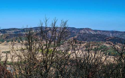
Little Blue Peak and Ridge from Grizzly Peak after the Rocky Fire swept over it. Oct 13 '15
Little Blue Peak and Ridge have been swept over by the Rocky Fire in summer 2015 and although it still requires route-finding it is no longer the bushwhacking epic it used to be. -ND
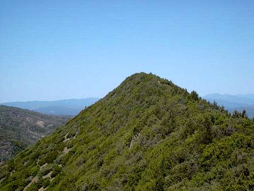
This peak has a name that doesn't do much to give it any kind of an air of adventure. In fact at 3120 feet, many would consider this a pipsqueak of a mountain heightwise. It certainly isn't in the class of the great mountains of the Sierras or the Lassen or Shasta's of the golden state but yet it is considered one of the most difficult county highpoints to get in the state of California.
The main reason it is climbed at all is due to the fact that it is the highpoint of Yolo county. Getting the Yolo county highpoint is to do battle with brush, seriously nasty brush, thick brush, awful brush. Brush that rips at your clothing, tears at your skin and makes you earn every foot forward once you enter its evil domain. Of course, that is if you do it by the one legal route, the BLM route which will be covered elsewhere on this page. Protective eyewear is recommended as you do this leisurely stroll in the thickets.
Eighteen people at this time have completed all of the county highpoints of California and several more are within striking distance of having them all done but in order to get them all, you have to do this one. Most would rather do Mt. Shasta, No. Palisade or Mt. Whitney but yet, in the reality of county highpointing, this one is every bit as important as the others.
The name Yolo (thanks to Gary Suttle for this information) most likely comes from the Indians who inhabited the area. It means "a place abounding with rushes". Suttle mentions that rush filled marshlands once prevailed in the low areas of Yolo county. Woodland, just off of I-5 is the county seat of Yolo county. See the overview map at the bottom of this page. Realize that Sacramento and the airport are to the east and southeast of Woodland.
Little Blue Peak wasn't always considered the highest point in Yolo County. Berryessa Peak (elev 3057) once had that honor but thanks to Dingus Milktoast for this interesting info:
"Berryessa, was once considered the hp of Yolo county, till 1991 when John Sarna discovered Little Blue. Good thing, as the private landowners that surround Berryessa Peak absolutely refuse to allow public access to Berryessa, which is on BLM land too. In fact, Berryessa Peak is the largest tract of BLM land in the U.S. suffering from no public access whatsoever. Efforts to gain rights of way access to this land have been for naught thus far. A proposed Blue Ridge Trail would start at Fiske and go clear to Putah Creek at the dam for Lake Berryessa, over 30 miles if ever completed. Many of us coast range hikers long for that day" For some more information on this, look at this LINK
The nearby Cache Creek BLM Natural Area is worthy of a visit while you are in the area. For information on this area, click HERE
 |
 |
 |
 |
The Naming of the peak- Thanks to SP member Dingus Milktoast for this info about
why we call this one "Little Blue Peak"
"There is no 'official' Little Blue Peak. That's the moniker applied by county highpointers. The name of the formation is Little Blue ridge.
Little Blue Ridge is of course named after the Blue Ridge. Not the one in Virginia, Tennessee, etc. This is the Blue Ridge visible from Sacramento, looking west. Its named Blue Ridge cause it in fact looks blue frequently, due to the bluish-green cast of the Blue oaks growing there.
Little Blue Ridge is considerably shorter than the Blue Ridge, though slightly higher in elevation. Berryessa Pk was long credited at the high point of Yolo county. Its the antenna festooned summit visible from the Cache Creek casino, looking west. Little Blue "Peak" was discovered by some dude named John Sarna and documented by Gary Suttle in his CA Highpoint book.
But you haven't REALLY climbed Little Blue Peak till you've done so from the banks of Cache Creek at Bucks Bar. Good luck with that one."
Signature Photo by Bob Burd
Getting There
UPDATE: Read this update (thanks to Dingus Milktoast) prior to reading the remaining "getting there" directions. This does change things quiteR a bit.
Rayhouse Rd Permanently Closed
"Note that as of Jan 2009 Rayhouse Rd is permanently closed. The Low Water bridge over Cache Creek is broken and the county doesn't want to spend a million bucks on a bridge used mostly for one company (the rafting company' access to Buck Island), tweakers, drunks and NRA nutbergers. So the county elected to discontinue maintenance on the road. The net is this removes access to Little Blue from the Yolo county side (Cache Creek canyon). One can still access the trailhead from Reiff off the Knoxville Berryessa Rd in Lake County.
This road is now permanently closed. It effectively seals off a huge chunk of BLM land from 4 wheel access. While this impacts me quite significantly in a negative way - on balance I think it is good for the area. It will become more and more wild over time, as a direct result.
However, my attempts at establishing another route to Little Blue, from Buck Island over Brushy Peak (as far as I'd got) onto the flanks of Little Blue - have been for naught."
---------------------------------------------------------------
As listed before:
There are two ways to get to the trailhead for this one but the one that is most straightforward is from the town of Lower Lake (Highways 53 and 29 meet in the center of this town) Go east on the main street in the center of town which becomes Morgan Valley road until you find Reiff road, which goes off to the left while Morgan continues on to the east. It seemed like Reiff road was about 10 miles from Lower Lake so you need to be attentive to find this road (a GPS pre-loaded coordinate is helpful). Once on Reiff, it is roughly 3 to 4 miles to the TH (guesstimate), the road will eventually become Rayhouse Road at the Lake County /Yolo county line. Along the way you'll pass a sign warning about mud, which should be heeded during the rainy season.
The mud is heinous and of the slick but track filling kind that makes even 4WD helpless. If it is raining, come back another day. If dry, continue and drive up the hill past the "castle" to this point where there is a place to pull off the road and park. A chain and a BLM sign marks the spot.
There is also a route in from the east and it is found in Gary Suttles' book "California county summits". I will add this route in the near future as I continue to develop this page. This route is often gated closed at the other end and such was the case when I was there so I have no experience with that entry route.
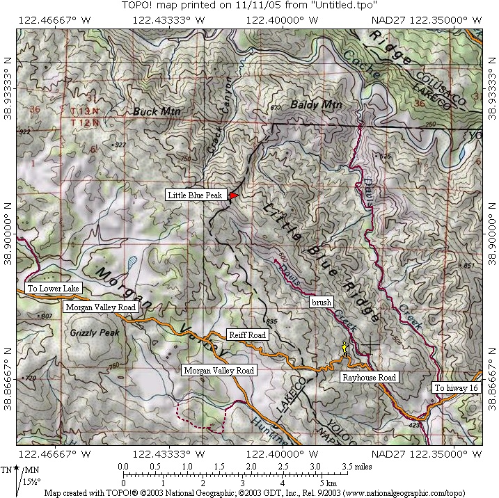
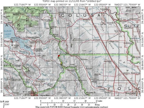
This map will help orient you to the area
If you'd like to see a bigger version of the above map, click here.
BEST MAP OF ROUTE has recently been created by Bob Burd. Check it out HERE. . He has detailed the DMT Highway route.
Round trip: 8 1/2 miles Elevation gain: 1900 feet Time required variable
Additional info on closed roads (worth a look before going) can be found HERE at the Yolo county DOT.
Questions about mud or the eastern gate?
Yolo county Road Maintenance
916-666-8032
The route description by Dingus Milktoast is a MUST read. Read all of it.
Red Tape
No permits are required at this time but charging anyone to do this hike would border on the criminal since only an insane county hunter, driven by the need to get em all would even consider doing this one. Am I beginning to get you interested in this one? Stay tuned, I'll add more enticement to whet your appetite in a section you'll find at the bottom of this page once I get it developed.
More information may be accessible through the BLM office:
BLM Clear Lake Resource Area
555 Leslie St.
Ukiah, Ca 95482 707-462-3873
When To Climb
You could climb this peak anytime of the year but I wouldn't recommend it in the summer. The heat would probably do you in. The best time would be when it cools down mid October thru late April. I did it in December and that was a good time to do it. Do not attempt this hike when it is raining as the roads leading in turn to a slippery slimy mud that not even 4WD traction will save you from.
A register adorns the top of this peak. Well, adorn is a pretty fancy description of some rocks surrounded by brush. However, just a bit east from the high spot, there are some nice views.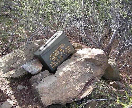
The register with a few of the names 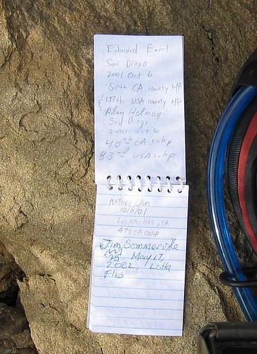
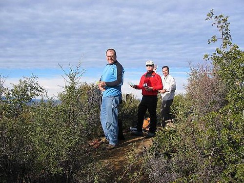
The summit area of the peak with Chris Doig, Dan Baxter and Dennis Poulin enjoying the views.
 |
 |
 |
 |
 |
Camping
We camped in our vehicles at the trailhead. Generally, it is ok to camp on BLM land as long as you observe LNT principles. Do not camp on private land and about a mile east, there is a spot to camp where the road reaches a saddle.
Mountain Conditions & Poison Oak
Weather conditions can be found at the bottom of this page.
Brush, brush brush. Poison oak, occasional bears and more brush. It is possible that rattlesnakes might be encountered as well. A really nice area. Dennis Poulin spotted a big black bear (brown colored one) on his first trip to the peak via the BLM route.
POISON OAK Click here for more info on it
Another word about poison oak. It is very prevalent along the creek and you must wear long sleeves, long pants and take the necessary precautions against it if you are susceptible to its ill effects. It took Dennis two weeks to get over his dealings with it and I just received an email from a person who recently did the peak & had to take prednisone for a week after he did the BLM route. Please take heed of this nasty plant and be prepared to deal with it. You might want to buy some Technu and have it in your car or pack. You can buy it at most drugstores, no Rx required for about ten bucks. If you are exposed to poison oak and are sensitive to it, that will be the best ten bucks you ever spent.
Bears are known to be in the area and have been seen by Dennis Poulin and reported to me via a conversation I had with the landowners. They are shy however and avoid humans. Rattlesnakes are present but none have been seen by anyone who has done the peak. The landowners mentioned that their dogs have had contact with rattlers from time to time. Ticks can be a problem in the springtime and early summer.
Routes
There are two routes you can take to get this peak. The mostly legal route is known as the BLM route and was mentioned by Gary Suttle in his book as well as Anthony Chan and by Dingus Milktoast.
See the BLM route-The Milktoast Highway at the left for the best description of the route.
Route 1: BLM route
The BLM route described by Gary Suttle, along the ridgeline to the high point, is now nearly impenetrable due to dense growth of thorn bush. The BLM route does cross some private property but the landowners don't have a problem with crossing their land at that point. See my trip report for full information on that aspect.
The 2nd route is on private property for the most part and after talking with the landowners, I don't recommend crossing private property even though that would make this one a lot easier. The BLM route is the only route we as county highpointers and peakbaggers should do so I won't post a route that includes the crossing of private land. I explain this in more detail in my trip report (found in the trip report section)
Summary:
Route 1: BLM route (see the BLM - The Milktoast Highway) Excellent information from the one guy who knows this area best.
Route 2: Private property - not a recommended option. The landowners have been approached for permission in the past by Gary Suttle and by myself and they have asked that no one trespass on their property. The part of private property that is on the BLM route and is crossed is ok with them but only that part. While it is much easier to do this peak via the use of the private property that borders the southern edge of the Davis Creek drainage, you would do so at your own risk. The landowners have dogs that are very effective in keeping you from "stealthing" this one. As the maintainer of this page, I would suggest that we honor the landowner's request.
Anthony Chan's Map is a great resource in visualizing the BLM route
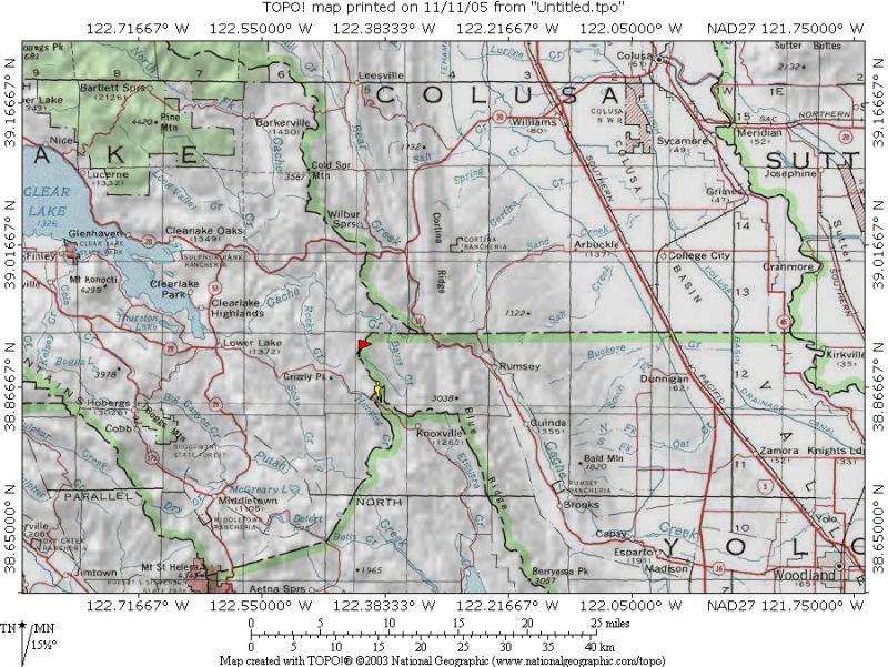
Overview map
To see a bigger version of this map, click here
What others have said
Dingus Milktoast had this to say:
I live in the Sacramento region and had hiked in this area long before I became aware of county high pointing. I was intrigued by Gary Suttle's implicit challenge of the "all BLM approach" to this peak. I decided to take up that challenge. I tried his suggestion. hike down to Davis Creek, then scale the opposite ridge and bushwhack to the summit. Impossible! I tried the ridge in 2 different places. The chaparral on top of Little Blue Ridge is impenetrable; period. I don't know if I would have used that word until I got a look at that bush. A bulldozer or maybe a troop of 50 boy scouts are perhaps the only pruning tools that could make a dent!
But while scouting up the ridges, I was able to spot a potential trail out of the canyon on the opposite (west) side, leading up to the area east of Butte Rock.
So eventually (it took 3 trips counting the abortive attempt on the ridge) I was able to blaze an all-BLM trail that circumvents the need to cross private property fences. If any of you decide to use "my" trail notes in the future, I offer the following name for the route, "The Milktoast Highway" [sic]. (don't ask me why this is all underlined, there is no HTML being utilized on either this paragraph or the one below)
Peter Maurer had these choice words:
Following the directions of Craig Harris and others, we completed this most miserable of hikes (if one can call six hours of crawling through chaparral a hike) in 10 hours. I was more exhausted and sore than hiking Whitney in one day! This peak takes a lot of perseverance and is NOT for the faint of heart. The Oregonian he mentions in his report is none other than Dennis Poulin, who served as our guide for our group.
Garrick Meeker said it took him 19 hours to complete the hike since he got totally lost and ended up spending a miserable night in the brush.
Jim Sommerville managed to do this in the middle of May, 2002:
"As suggested in the trip report by Craig Harris, the all-BLM route is no walk in the park. Take lots of brush, slippery rocks, wet feet add a ton of flies and you have an all-day adventure. "
Dennis Poulin has posted a great trip report about his first hike into this peak. A must-read.
Bob Burd has posted these comments, heed them:
Note Dingus's NEVER AGAIN in the text. Yet less than two months after his last visit, he's crawling back up there with me in tow. Hah! I thought the entire trip up the creek was great fun, actually. Of course, I completely ignored the poison oak warnings, and am paying for that now. Oh, and there's almost no chance of finding the correct place to leave the creek unless you've been there before, have a guide, or use a GPS. I was ready to climb out about three places before the correct one, as well as following the wrong creek fork several times.
I'm sure others will chime in with their experiences when they discover this page has been put up. However, if one can use the private property to the south, much of the misery is prevented but the landowners are not keen to trespassers and I'll explain why in my trip report
Here are two entries from the summit register: 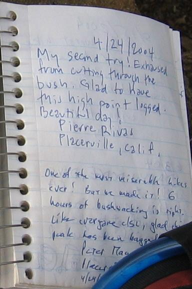
 |
 |
 |
 |
 |
TRIP REPORTS & COUNTY HIGHPOINTING
A wealth of trip reports on this peak can be found at these sections to the left of this page:
1. Trip reports (at the left)
2. Links - I have linked 7 trip reports from www.cohp.org here.
Gary Suttle stimulated a lot of Californians to start chasing the California highpoints when he wrote his book (still available via Amazon) "California County Summits" It is still the Bible of California county highpointers but thanks to the www.cohp.org group, there are updates and access to topozone maps on all of the counties. Gary's book was written in the early 90's and some of the information is outdated but again, check the cohp website for the updates. Dan Baxter and Dennis Poulin have completed most of the California highpoints and are an additional resource. Dan has posted good informational pics on many of the counties at this Webshot site and you could email Dennis for specific information should you need more.
California county highpoints
Consider joining in the fun of chasing the county highpoints. The challenge is great but so is the feeling of accomplishment and you also will get to see all of California in the process. Significant California county highpoints:
Mt. Whitney / Mt. Shasta / Lassen Peak / White Mtn Peak / Mt. Ritter
No. Palisade / Lyell Peak / San Gorgonio / San Jacinto and much much more.
Weather in the area
Clearlake is the biggest town with a weather report that may be of value.
Click here for Yahoo's weather report. ![]()
![]()
Yolo County
External Links
- Craig Harris Trip Report (valuable info)
- 7. Garrick Meeker's trip report
- 6. Peter Maurer's trip report
- 5. Jim Sommerville's trip report
- 4. Pam Thompson's trip report
- 3. Hang Dog Ted's trip report
- 2. Edward Earl's trip report
- 1. Anthony Chan's trip report
- The Milktoast Highway - Feb 3, 2006
Bob Burd's excellent Trip report with pics
DMT update as of Dec 2009
I saw this on the forum and thought it'd be worth sharing here:
PostPosted: Thu Dec 24, 2009 1:30 pm GMT
Bob Burd wrote:
Any hijinx from the Mud Pirate this time?
Dingus Milktoast wrote:
Hey there Bob
Nope, not this time. Now that the road is permanently closed at the county line there is a big sign at the start of Reiff Rd to warn the casual passers by off. I think his car rescue business is way down.
His black water hoses are still in the ditch though, ready to deploy.
He knows my jeep and me, I've talked to him several times now, once from the window of my jeep. He leaves me be, imagine that... someone who is freaky enough to scare off the mud pirate.
Weird thing dude... there is very little evidence left of the work we did. That first section where we descended from the road down the gully into the creek - completely overgrown and smashed down... trail just disappeared. It was so different I actually thought I'd gone down the wrong gully! Got scratched up before I got to the creek!
Wasn't sure till I hit the cairn on the tree trunk in Davis Creek, that I was even on track, very weird. I gave me a weird vibe too.
Along the creek there was very little evidence left and I had to look hard for what I found. Only occasionally would I see the marks of a cut branch.
That one area where we spent that time hacking through a long section standing in the cold water - a good case in point. There were some big cuts still visible but it was still very hard to get through there. It was like someone just pushed the canopy of the brush down, collapsing the canopy over the trail in the process. I had to bloody crawl again!
A couple of years ago a freak storm hit the sides of Fiske Peak and knocked down a bunch of trees and brush, yet no peaks or slope aspects near Fiske showed signs of similar damage. It was like one of those microbursts had hit it. Or maybe a tornado or down burst.
And I looked hard at neighboring peaks too, as I spent a lot of time on Fiske cleaning the trail and wondering about the storm. See all the trees and all the brush all fell over in the same direction!
Anyway, I think something similar enough happened to the Milktoast highway. It was like a giant hand just compressed the chaparral and pushed it down. The chaparral is reclaiming the Milktoast Highway... it needs another Lopper Crew. If these boys actually show up I will make sure they are equipped!
DMT
Bob Burd - Feb 7, 2006 1:56 am - Hasn't voted
Untitled CommentTurns out the road is muddy not just at the doing of Mother Nature, but with some significant help from a local dubbed the Mud Pirate. I'm not kidding. Just past

the driveway leading to the Mud Pirate's lair (about a mile before the trailhead on Rieff Rd) is the nastiest section of muddy road that is intentionally made so. Below is a photo of a hose running from a natural spring on the hillside out to the middle of this steep section. This hose was not there when we passed by in the morning:
Dean - Apr 2, 2009 3:36 pm - Hasn't voted
Re: Rayhouse Rd Permanently ClosedThanks for this update. I've added this info to the front page "getting there" section.
Noondueler - May 10, 2015 5:49 pm - Voted 10/10
coordinateshave drifted from summit the Dean. I recently added it to the Clear Lake Area Page. Cheers,Windsor
Dean - May 10, 2015 6:34 pm - Hasn't voted
Re: coordinatesWindsor, I have added you as an administrator to this page and if you are interested, I would be happy to turn the page over to you since this one is just about in your back yard. That seems to make more sense than me trying to stay on top of what is going on in that area. Let me know if you want it.
Noondueler - May 10, 2015 10:24 pm - Voted 10/10
Re: coordinatesYou know Dean, I don't think I'll ever bother with that peak. I'm not a county high pointer and since Little Blue is such a brush slog challenge... I don't have a connection with it or the passion for it but maybe I could manage the page. What do you think?
Dean - May 10, 2015 10:35 pm - Hasn't voted
Re: coordinatesThat would be fine. I've added you as an administrator so if you see anything you want to add or tweak or delete, feel free to do so. You'd be smart if you never chased after that one but in a moment of total boredom, you might be tempted just to see what the alure of such a poison oak infested brush fest might be. However, I'd caution you, don't do it. : ) Thank you, I should add that you are truly the one I feel is an expert of that section of California.