
-
 32295 Hits
-
 91.59% Score
-
 36 Votes
|
|
Mountain/Rock |
|---|---|
|
|
43.94130°N / 114.9339°W |
|
|
Hiking, Mountaineering, Trad Climbing, Mixed |
|
|
9901 ft / 3018 m |
|
|
Overview
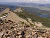
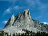
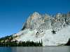
Idaho's version of the famous rock buttress is located in the south-east portion of the Sawtooth Range. Because of it's name and it's proximity to Alice Lakes (one of the best backpack spots), El Cap sees it's fair share of summit visits. Most are via the East side scramble, which offers excellent and steep rock hopping with a powerful summit view that overlooks from the precipitous north face onto Alice Lakes and Twin Lakes. Nearby Parks Peak and Snowyside Peak are also excellent scrambles. El Capitan gets it's name from it's impressive dome-like face on it's west wall. There are 2 known rock routes and the potential for expansion.Mountain Goats have been seen on El Capitan and are common visitors to the higher slopes in the Sawtooths. According to Douglas H. Chadwick's "A Beast the Color of White", Idaho was one of the first states to recognize in the 1950's that the goat population was dwindling. After instituting hunting limits, the goat population more or less stabilized, unlike many other areas. It is currently believed that there are 2200 to 2500 white climbers left in Idaho. Chadwick's book on Mountain Goats is virtually the only complete text on this wonderful animal. Although quite scientific and slightly out-dated, it should be a standard read for mountaineers. After all, climbers probably see more goats each year than any other group. Most people will never get to see the Mountain Goat in it's true, high elevation setting.

El Capitan was first climbed in 1935 by the Underhills and Dave Williams. Williams was a local jack of all trades, owning a butcher and bake shop, delivering mail, mining, mountain goat hunting, and apparently one of the first mountain guides in the region.
Here are the routes on El Capitan:
1) East Ridge (Class 3) - Just northwest of Alice Lakes at the 8600 ft level, leave the trail and head southeast up into a bowl on the north side of El Capitan. Find your way up to the east ridge, occasionally dropping down on the northeast side to avoid harder terrain. The summit ridge is magnificent as you can peer over the vertical north face.
2) Northeast Ridge (II 5.2) - Start just northeast of Alice Lakes on a bench and make your way up a series of ledges via short chimneys until you reach the steep headwall on the northeast side. Aim for the notch between the north summit and the true summit. Make your way south onto the true summit. Use the East Ridge to descend.
3) North Face (II 5.2) - Find the east face of the north tower (utilize the NE Ridge directions). From the notch described on the East Ridge, continue out onto the north face via a series of ledge systems. Climb the ledges via easy, but often loose rock.
 |  |  |  |  |
Getting There
Road Approach- >19 miles south of Stanley on ID-75, go west onto Pettit Lake Road and follow a well maintained road for 2.5 miles to the Tin Cup Trailhead.
Hiking Approach
- This trail is crowded by Idaho standards. Follow the trail past Pettit Lake and follow Pettit Creek toward Alice Lakes. Leave the trail at 5.1 miles (just before Alice Lakes) and ascend the bowl on the northeast side of the peak.
Note: This trail is part of an amazing 22 mile loop possibility; Good trail run or backpack. Loop starts and finishes at Pettit Lake and passes many backcountry lakes: Toxaway, Twin, Farley, Alice
Maps: USGS Snowyside Peak Quad (43114-H8-TF-024), EarthWalk Sawtooth National Recreation Area Map (overview of the whole range)
 |  |  |  |  |
Red Tape
There are no hiking or parking regulations or fees. Backpackers must register at the trailheads and many alpine lakes have campfire restrictions.When To Climb
Standard climbing season is June through October. Conditions vary greatly. The Sawtooth Valley can be one of the coldest areas in the nation during the winter. Negative readings are often common. Snowfall can vary and occur at any time. Summer days can still be hot, but you'll probably never experience 90 or above, especially once you get up higher.Nearby Stanley, Idaho Climate Data:
| Jan | Feb | Mar | Apr | May | Jun | Jul | Aug | Sep | Oct | Nov | Dec | Annual | |
| Average Max. Temperature (F) | 27.0 | 33.7 | 42.5 | 50.3 | 59.9 | 68.4 | 78.7 | 78.4 | 68.6 | 56.6 | 38.1 | 26.0 | 52.4 |
| Average Min. Temperature (F) | -0.5 | 0.3 | 9.7 | 20.3 | 28.3 | 33.9 | 36.0 | 34.0 | 27.2 | 20.6 | 12.0 | -0.8 | 18.4 |
| Average Total Precipitation (in.) | 1.64 | 1.33 | 1.02 | 1.02 | 1.17 | 1.16 | 0.59 | 0.59 | 0.78 | 0.92 | 1.46 | 1.55 | 13.24 |
| Average Total SnowFall (in.) | 16.9 | 13.2 | 10.2 | 3.4 | 0.9 | 0.2 | 0.0 | 0.0 | 0.4 | 1.7 | 10.4 | 14.6 | 71.9 |
| Average Snow Depth (in.) | 18 | 20 | 15 | 6 | 0 | 0 | 0 | 0 | 0 | 0 | 2 | 8 | 6 |
Camping
Camping
- There are many drive-in camp sites at Pettit Lake
- Spectacular backcountry camping exists at Alice Lakes, Twin Lakes, Toxaway Lakes, Yellowbelly Lake, or Farley Lake
 |
Mountain Conditions
Latest Avalanche Report (Sawtooth Area)
http://www.avalanche.org/~svavctr/
National Weather Service Current Forecast for Stanley:
External Links
- Sawtooth Avalanche Report
Measurements at Titus Ridge
- Stanley, ID Weather
From the NWS