
-
 15575 Hits
-
 94.82% Score
-
 49 Votes
|
|
Mountain/Rock |
|---|---|
|
|
45.51290°N / 7.28527°E |
|
|
Mountaineering |
|
|
12391 ft / 3777 m |
|
|
Overview
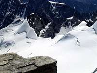
Elegant and conspicuous, this important peak by the many turrets is thirteenth highest in the Gran Paradiso Group. It is surrounded by Colle della Luna (3.542m) and Testa della Tribolazione (3.642m) on the East side, and by Colle Chamonin (3.698m) and the powerful and sharp Cresta Gastaldi (3.894m) on the West side. The steep Southern aspect of Punta di Ceresole rises above the Noaschetta Glacier, while the North side is almost entirely covered by the huge Tribolazione Glacier. The peak is easily seen from as far as Cogne (1.534m) and from the Village of Gimillan (1.787m).

Elegante e vistoso, questo importante picco dalle tante torrette risulta la tredicesima Vetta più alta del Gruppo del Gran Paradiso; é circondato dal Colle della Luna (3.542 m) e dalla Testa della Tribolazione (3.642 m) sul lato Orientale, e dal Colle Chamonin (3.698 m), subito seguito dal potente tagliente della Cresta Gastaldi (3.894 m), sul lato Ovest. L'aspetto Meridionale della Punta di Ceresole si profonde ripido nelle sue linee al di sopra del Ghiacciaio di Noaschetta, mentre il lato Settentrionale è quasi interamente ricoperto dall'enorme Ghiacciaio della Tribolazione. Il picco è facilmente visibile dalla distanza da Cogne (1.534 m), nonché dal soprastante Villaggio di Gimillan (1.787 m).
First Ascents
- S-W Side: A. E. Martelli, J. J. Maquignaz and S. Meynet, (Jul 01th, 1874).
- S-E, Sperone Sud: M. Baretti, L. Barale, A. and G. Castagneri, (Jul 05th, 1874).
- W Ridge: G.Yeld, A. Payot and L. Guichardaz, (Aug 05th, 1879).
- E Ridge and N Side: W. A. B. Coolidge, Christian J. Almer and R. Almer, (Aug 13th, 1888).
- E Wall: G. Costa, A. Notario and L. Saletti, (Sep 24th, 1940).
- S-SW Edge: A. Bernocco, A. Bonatto, A. Casetti E. Roscio, O. Ravizzolo and A. Vaja, (Aug 12th, 1941).
 |
 |
 |
 |
 |
Getting There
BY CAR:
- From Torino, Milano, etc: Motorway A5. Exit at Aosta Ovest. Drive to the nearby Aymavilles. Follow the directions for Valle di Cogne.
- From Switzerland: through the Grand Saint Bernard Tunnel or the namesake Pass. Drive to Aosta, then follow the direction for Courmayeur on SS.26. Just after Sarre, turn to the left, in the direction of Valle di Cogne.
- From France: through Mont Blanc Tunnel or Petit St. Bernard Pass. It isn't necessary to take Motorway A5: you can drive on SS.26, in the direction of Aosta. Before arriving at the Village of Sarre, turn right following the sign for Valle di Cogne. After Aymavilles, the SR.47 crosses the Villages of Vieyes, Epinel and Cretaz and after about 25 Km arrives at Cogne (1.534m).
BY PLANE:
- Aeroporto "Corrado Gex" Saint Christophe (Aosta).
 |
 |
Route
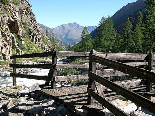
First day: From Cogne (1.534m) by bus or car to Valnontey (1.666m). Cars can be parked in the large square near the center of the village. Start the ascent of the Valnontey Valley on its orographic right side (climber's left). Go past the pleasant Pastures of Valmiana (1.728m) and reach the Erfaulet Bridge (1.830m); cross it and continue along the trail to a fork (2040m, 1h'15/1h'30), where you take the left branch. Follow the right bank of the torrent and head for the moraine called "Barma des Bouquetins"; (2.698m). Climb the morain's ridge in its entirety reaching a hump. Follow this relief to a large snowfield, at the end of which you can discern a ledge going left. Climb on a faint, exposed trail for the entire length of the ledge; turn right and reach a small hanging valley. Head for the opposite side, and climb to a glacial dell between two spurs, cross it in the direction of a distinct rock gully. Climb the gully with circumspection, for the rocks are often covered with verglas and gravel. Past the gully, you'll get to the top of the spur where two fixed bivouacs are located: C. Pol (3.183m, sleeps 6) and M. Gérard - E. Grappein (3.200m, sleeps 9). It requires 5h'30/6h'30 from Valnontey.
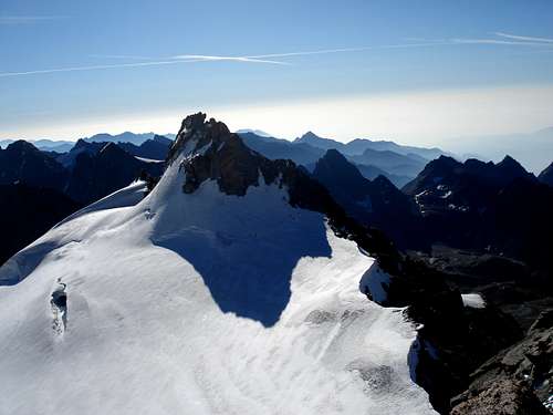
Second day: Go toward the cliff directly behind the two bivouacs for about one hundred meters, then turn left (beware of crevasses) aiming for Colle della Luna. (On the left one can admire the great seracs coming down from Testa della Tribolazione) Skirt the large crevasses and continue past Punta di Ceresole, aiming for Colle Chamonin (3.692m). From there, climb the snow ridge to the large shoulder under the Summit. Cross on the South Face to the base of a short chimney-gully that ends at a narrow notch between the Summit and a slightly lower gendarme. From the notch, it is an easy climb to the Top. The route from the col to the Vertex can be rather nasty when covered with fresh snow or vergalss: pay due attention. This is in any case an alpine route that requires fitness and experience.
Descend: By the same route.
Primo giorno: da Cogne (1.534 m), in autobus o in auto sino a Valnontey (1.666 m). I mezzi posson essere parcheggiati nel piazzale vicino al centro del paese. Iniziare la salita della Valnontey sul lato orografico destro (sinistra per chi sale). Si superano i piacevoli Pascoli di Valmiana (1.728 m) raggiungendo il Ponte dell' Erfaulet (1.830 m); attraversarlo e proseguire lungo il sentiero insino ad un bivio (2.040 m, 1h'15/1h'30), ove si prende il ramo di sinistra. Seguire la sponda destra del torrente e la testata della valle per la morena chiamata "Barma des Bouquetins"; (2.698 m). Proseguire completamente sul filo della morena per poi raggiungere una gobba. Seguire questo rilievo sino ad un grande nevaio, al termine del quale si può scorgere una sporgenza sulla sinistra. Salire su d'una piccola traccia e con percorso esposto per tutta la lunghezza della cengia; voltare a destra pervenendo ad un valloncello sospeso. Continuare sul lato opposto, e rimontare sul ghiacciaio frammezzo a due speroni rocciosi; dopodiché lo si attraversa in direzione d'un evidente canalone roccioso. Superare la gola con prudenza, causa le rocce spesso ricoperte da verglas e ghiaia. Oltrepassato il canalone, si arriva alla cima dello sperone dove si trovano i due bivacchi fissi: Carlo Pol (3.183 m, 6 posti letto) e Marcello Gérard - Ettore Grappein (3.200 m, 9 posti letto). Il percorso richiede 5h'30/6h'30 da Valnontey.
Secondo giorno: procedere verso i risalti subito addietro ai due bivacchi per circa un centinaio di metri, poi svoltare a sinistra (attenzione ai crepacci) puntando Colle della Luna (dalla sinistra si possono ammirare i grandi seracchi discendenti dalla Testa della Tribolazione); scartare i grandi crepacci e proseguire oltre la Punta di Ceresole, puntando al Colle Chamonin (3.692 m). Da lì, scalare la cresta di neve della grande spalla sotto la Vetta. Attraversare sulla Parete Sud alla base d'un breve canale-camino terminante in uno stretto intaglio tra la Vetta ed un gendarme di poco più in basso. Dall'intaglio una facile arrampicata porta alla Cima. Il tratto da colle a Vetta può esser piuttosto brutto quando le rocce risultan ricoperte da neve fresca o verglass: prestarne la dovuta attenzione. Questo è in ogni caso una salita di montagna richiedente sia capacità che una buona esperienza.
Discesa: Per la stessa via.
Difficulty
The route is rated from PD (a little difficult) to AD (rather difficult), depending on the mountain conditions.La via é da valutarsi da PD (poco difficile) ad AD (abbastanza difficile), in relazione alle condizioni della via.
Gear
Mountaineering equipment, including rope, ice axe, and crampons.Equipaggiamento, da alta montagna, inclusi corda, piccozza e ramponi.
Huts
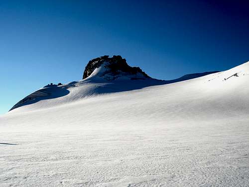
From Cogne: Bivacchi Carlo Pol (3.183m) and M. Gérard - E. Grappein (3.200m), located on the spur that divides the northern and southern branches of the Tribolazione Glacier. Difficulty: PD. Reachable from Valnontey (see above). |
 |
 |
 |
 |
Red Tape
Within the borders of the P.N.G.P. (Parco Nazionale del Gran Paradiso), at the moment (summer 2004), dogs generally are not allowed, except on a couple of trails, and camping is forbidden (except for climbers from sunset till dawn). No fees are due.
Campings
- Wild camping in the Parco Nazionale del Gran Paradiso is strictly forbidden!!!
Mountain Condition
- Meteo: you can find all the needed informations at the official site of the Valle d'Aosta Region:
- Valle d'Aosta Meteo
- Meteo: You can find more weather information on the website 3B Meteo:
- Meteo Cogne
- Meteo: You can find more weather information on the website 3B Meteo:
- Meteo Valnontey
Webcam
- WEBCAM on Aosta Valley:
- Webcam
Books and Maps
BOOKS:
- "Guida delle Alpi Occidentali", di Giovanni Bobba e Luigi Vaccarone C.A.I. Sezione di Torino Volume II (parte II), 25 Maggio 1896.
- "Guida della Regione Autonoma Valle d'Aosta", di Mario Aldrovandi; Ed. S.P.E. di Carlo Fanton, Torino 1964.
- "Rifugi e bivacchi in Valle d'Aosta", di Cosimo Zappelli aggiornata da Pietro Giglio, Musumeci Editore, Luglio 2002.
- "Guida dei Monti d'Italia-Gran Paradiso Parco Nazionale" E. Andreis, R. Chabod, M. C. Santis, Club Alpino Italiano/Touring Club Italiano, prima Ed. 1939; seconda Ed. 1963; terza Ed. 1980.
- "Il Parco Nazionale del Gran Paradiso (Valli di Champorcher-Clavalitè-Saint Marcel-Laures-Cogne-Valsavarenche-Conca di Pila", di Giulio Berruto 3/volume 2°, IGC Torino; prima Ed. 1981; seconda Ed. 2000 (in Italian).
- "Gran Paradiso", A. Gegenfurtner, G. Klotz, F. Müller, Ed. Bergverlag Rudolf Rother, Monaco 1980 (in tedesco).
- "Gran Paradiso", G. Klotz, Ed. Bergverlag GmbH Rother, Monaco 2005 (in tedesco).
- "Gran Paradiso", di Pierandrea Mantovani e Renato Misischi, Ed. Rassegna Alpina, 1974.
- "Gran Paradiso-Itinerari Alpinistici e Sci Alpinistici", di Franco Brevini, Ed. Musumeci, Giugno 1982.

|

|

|

|

|
MAPS:
- Kompass "Gran Paradiso Valle d'Aosta Sentieri e Rifugi" Carta Turistica 1:50.000.
- SIRIO Blue Vision "Cogne Valnontey" Carte fotografiche.
- A.I.A.T. Cogne "Gran Paradiso-Cogne Aymavilles" Walking Map 1:25.000.
- I.G.C. Istituto Geografico Centrale Torino "Gran Paradiso-La Grivola-Cogne" 1:25.000.
- Studio F.M.B. Bologna "Gran Paradiso" 1:50.000.
- Enrico Editore Ivrea-Aosta "Gruppo del Gran Paradiso" 1:50.000.
- L'Escursionista "Valle di Cogne Carta dei Sentieri" (n° 10) 1:25.000.
- L'Escursionista "Tour de la Vallée de Cogne Grand Paradis" Carta dei sentieri 1:25.000.
Important Information
- REGIONE AUTONOMA VALLE D'AOSTA the official site.
- FONDAZIONE MONTAGNA SICURA Villa Cameron, località Villard de la Palud n° 1 Courmayeur (AO) Tel: 39 0165 897602 - Fax: 39 0165 897647.
- SOCIETA' GUIDE ALPINE DI COGNE Tel. 347/9473526 – 328/1373728.
- A.I.NE.VA. (Associazione Interregionale Neve e Valanghe).
- A.IA.T. Cogne Gran Paradis via Bourgeois n° 34 Tel. 0165-74040. E-mail: aiat@cogne.org
- Ezio Sport articoli sportivi - via Bourgeois n° 64 Tel. 0165-74204.
 |
 |
 |
 |
 |
Useful Numbers
- Soccorso Alpino Cogne (SAR) Tel. 3482685406.
- Protezione Civile Valdostana località Aeroporto n° 7/A Saint Christophe (Ao) Tel. 0165-238222.
- Bollettino Meteo (weather info) Tel. 0165-44113.
- Unità Operativa di Soccorso Sanitario Tel. 118.
Acknowledgements
I want to thank Fabio (Brenta) for the translation of the text from Italian and also Livioz who provided the coordinates of the summit and helped with the edit. And to Osvaldo Cardellina) for the translation of the text from English to Italian.