
|
|
Mountain/Rock |
|---|---|
|
|
45.38420°N / 116.4849°W |
|
|
8210 ft / 2502 m |
|
|
Overview
This little known, rarely visited mountain is situated in the northern Seven Devils on the divide between Hells Canyon and the Salmon River Canyon. Though not as spectacular as its larger southern neighbors it is still a major rise of between 6,000 and 7,000 feet above the main canyons below and has 370 feet of prominence. The divide forms the east boundary of the Seven Devils Wilderness and the Hells Canyon National Recreation Area. The entire area is part of the Nez Perce National Forest, but the wilderness and NRA to the west are managed by the Wallowa-Whitman National Forest in Oregon. It has no official name and here is referred to as Papoose Cirque for descriptive purposes.This mountain is a ridge point that caps the spectacular subalpine cirque above Papoose Lake. There are a variety of routes that provide opportunity for short and easy hikes to the summit or highly technical rock climbing and everything in between. The cirque wall has four slots cutting through it, one is a steep scramble, one is perhaps a class 4 and two are vertical into overhanging rocks. The broad portion of the face appears to have some interesting scramble routes. Papoose Lake is a beautiful spot to camp and find solitude. Unfortunately there were signs of heavy cow use, which was surprising since this seems to a very difficult place for clumsy livestock to get to.
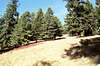
This beautiful area is somewhat marred by the skeletal forest of dead whitebark pine. Pine beetle and blister rust along with decades of suppression of necessary fire have combined to kill most of this subalpine forest type throughout the west. There are a few survivors, especially higher up where the bugs don’t survive as well and regeneration is good on the wilderness side of the divide where fires are allowed to burn, which improves habitat conditions and germination. The cooler bottoms and aspects support dense forest of subalpine fir and spruce. There is a healthy elk population in the area and a wolf pack has recently been documented.
 |  |  |  |  |
Getting There
Take Highway 95 to Riggins, which is 153 miles north of Boise or 118 miles south of Lewiston, Idaho. Just outside the south edge of Riggins, look for a large brown recreational sign for the Seven Devils and Heavens Gate. This will be Forest Service road 517. Turn west on this road and follow it about 17 miles to its end at the Heaven’s Gate parking lot. Take the trail north from the parking lot and hike along the Snake/Salmon divide for about 1.5 miles. The trail passes just east of the summit knob. For a better climb descend to Papoose Lake and climb the cirque back up.More interesting and challenging routes can be had from lower down on the mountain’s east side. There are several options, but it’s easy to get lost early on because the slopes are very non-descript at the start and its very easy to end up in the wrong basin before you’ve realized it.
North Ridge
Follow road 517 to mile 10.8, where there is parking at the junction of road 487 (gated). From here hike straight up the hill. There are several very used cow trails that look inviting to follow, but they will not go where you want. Cheat to the left (south) and always keep on a south aspect. If you find you’re on a north aspect start over. Eventually the ridge will become defined and you have a choice of what to do next.
One option is to hike to the ridge top, turn west and continue to the Salmon/Snake divide where you will find the Old Boise trail. Turn left (south) on this trail, and continue through the saddle that’s north of the summit and above Papoose Lake. Soon the trail will pass just below the summit on the left (east) side. It’s a short scramble to the top.
The second option is to stay below the ridge line and proceed across the slope aiming for the big cliffs of the cirque visible at the head of the basin. There will be several large subalpine grasslands to offer great views and keep the goal in sight. Numerous game trails will come and go along the way to make travel easier. Eventually these will form into one good trail near the west end of the last grass bald and continue to near the lake. The trail will disperse before the lake, but you will just about be there and will see where to go. From the lake there is the option of a class 3 scramble up the cliff face, four slots ranging from class 3 to highly technical or a steep hike to the saddle on the ridgeline just north of the summit and continue as above.
South Ridge
Follow road 517 for 11.5 miles to the 517F road. There is room for a few cars just beyond the junction. Hit the brush where the road curves out of view. This is about 150 yards beyond 517F. Hike up the ill-defined convex slope until the main ridge forms. Be careful not to get onto any north aspects because before you realize what happened you will be far off track in steep terrain. Once on the defined ridge just follow it up to the summit. This is about a 1.5 mile hike that rises a little over 1800 feet.
It is possible to start further up the road where room to park can be found at mile 11.9 and 12.2. The first point is more on the main ridge and should be a simple east to west hike, while the latter requires a short hike north up a steep south facing slope to the main ridge.
It may be possible to hike up the bottom of the basin along the creek, but this has not been explored. The creek often dries up and the down trees appear to be an obstacle in some of this area. Many maps show a Trail 115 that parallels the 517 road and cuts closer to the lake. This trail has not been used for many years and is almost impossible to find or follow. Don’t waste your time with it.
 |  |  |  |  |
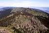
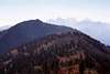
Views from the Summit
 |  |  |  |  |
Red Tape
None. If descending onto the west slope, standard wilderness regulations apply.When To Climb
June until late fall snows get deep (Oct or Nov).Camping
There are two small, primitive campgrounds a few miles further up the 517 road. The first is Windy Saddle Campground where road 517 crosses Windy Saddle. At this saddle a left turn leads to Seven Devils Campground, which is a short distance below near Seven Devils Lake. Papoose Lake itself is a very nice, isolated camping spot, but must be backpacked to.There is also the very small undeveloped Papoose Campground, which is situated in the bottom of Papoose Creek, just inside the Nez Perce National Forest boundary. A table and fire rind just off the side of road 517 is about all that marks the spot. The standard Nez Perce National Forest map has this campground erroneously placed a little east of the actual location. Its not very appealing.
 |  |  |  |
Mountain Conditions
Contact the Salmon River Ranger District of the Nez Perce National Forest for local information and current conditions.Salmon River Ranger District
Slate Creek Ranger Station
HC 01, Box 70
Whitebird, ID 83554
(208)839-2211
FAX:(208)839-2730
Hells Canyon NRA
Riggins Field office
189 Highway 95
Riggins, Idaho 83549
(208) 628-3916
This office is located near the south end of Riggins just north of where road 517 turns off of Highway 95.
NOAA Forcast
The Dead Forest
 |  |  |  |  |