
|
|
Mountain/Rock |
|---|---|
|
|
32.99268°S / 69.41952°W |
|
|
Hiking, Mountaineering |
|
|
Spring, Summer |
|
|
16732 ft / 5100 m |
|
|
Overview
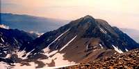 from Cerro Vallecitos NR
Among the main summits composing the mountain “Cirque” that surrounds El Salta de Agua camp (Cordon del Plata), Cerro Lomas Amarillas is the less high and features some non-technical or less-technical routes. Thus, it can be an interesting option as far as acclimatization.
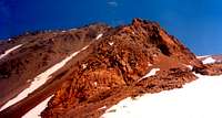 from El Salto de Agua
The name Lomas Amarillas means “yellow hills” and probably refers to some yellowish rocks that are found high on it contrasting with the dark rocks on neighbouring peaks. In fact, geologically speaking, this peak features amazing rock diversity.
Getting There
At an elevation of 2980m, Vallecitos ski resort is the gateway to Cordon del Plata range. Vallecitos ski resort
From The nearest big city, the provincial capital of Mendoza (altitude of 760m), take Route 7 toward Chile until the village of Potrerillos next to an artificial lake. Potrerillos is the last village where you can find basic supply: There is a pharmacy and a commodity store. Expreso Uspallata (EUSA) has several daily buses for about 1 US$ the journey lasting 1h15 to 1h45.
From Potrerillos to Vallecitos, there is no public transportation. If you don't want to hitch-hike, contact Refugio San Bernardo at 00-54-9-2614-183857 (from Europe), 011-54-9-2614-183857 (from North America) or 154-183857 (from Mendoza) and they will pick you up at Potrerillos bus stop with their car (3/4 persons max) for 35 Ar$ (= 11.5 US$ - Jan 2006 prices), even if you don't plan to spend a night there.
 from Cerro San Bernardo NR
Red Tape
No permit required (so far). Yet you have to register for safety reasons at Ski & Montana Hostal in Vallecitos ski resort.List of routes
 Southeast Ridge
Normal Route or South West Ridge, actually traversing bellow the ridge (walk-up --> PD)
Franke - Lomas Amarillas Traverse or South East Ridge (walk-up --> PD)
West Face gullies (F --> AD)
East Face (F+)
South Face or "Huaman" route (PD)
Camping
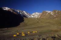
 El Salto de Agua campsite
The El Salto de Agua camp at 4200m is the most convenient camp to climb this mountain. It's situated 9 km & +1220m West of Vallecitos (7h30), next to a waterfall at the entrance of a "cirque" formed by (clockwise) Cerro Lomas Amarillas, Portezuelo Lomas Amarillas, Portezuelo Vallecitos, Cerro Vallecitos and Cerro Rincon. The company known as Ski & Montana provides base camp services (food, meals, tent rentals,...).
Other alternative camp sites are:
- Las Vegitas at 3180m is a nice meadow with lots of water available in the surroundings situated at about a km & + 200m west of Vallecitos ski resort (30' - 1h). It's a nice place to camp if going for Franke - Lomas Amarillas Traverse route.
 Las Veguitas campsite
- La Hollada (also spelled Hoyada or Ollada) at 4500m / 4520m, 1h - 1h30 (heavy packs) south-west of El Salto de Agua, can be a choice in order to cut down the distance if going for the South East Ridge route. There are usually running streams in the afternoon. This place is famous to be a low pressure spot, expect tough winds...
- Piedra Grande 3495m is not the safest place to camp... situated on the south side of the moraine, at about 1/3 of the way on the trail from Las Vallecitos resort to El Salto de Agua (2.5 km & +515m; 1h30 - 3h from Vallecitos), it's a basically a boulder field. Obviously the boulders have run down the next-by slope to end-up at this place. Doesn't mater if it was few years or hundred years ago. Just knowing that everything is loose up that ridge should be enough to avoid camping here. However if that's the choice, there are area less exposed 100 meters from the boulder field. There is a water stream about 5 minutes walk following a trail. If going for the glacier stream, have to filter the dark water.
First ascents
 Southwest Ridge
 West Face gullies
First ascent on January 31st, 1943 by Domingo Avalle and Miguel Caffaro, in a east (face) to west (face) traverse.
First ascent following the south-west ridge (considered as today normal route) by Domingo Avalle, Dr. Juan Corominas, Bernardo Miller and Hector Bressan, on December 30th, 1944.
First woman to summit: Maria Canals Frau on October 13th, 1945.
First ascent of "Huaman" route (south face) by Miguel Lito Sanchez and C. Tejerina, November 1987.
First winter ascent on August 21st, 1995 by Miguel Lito Sanchez and Herber Orona, through west face gullies.