
|
|
Mountain/Rock |
|---|---|
|
|
46.34402°N / 13.76767°E |
|
|
Hiking, Mountaineering, Trad Climbing, Sport Climbing, Big Wall |
|
|
Spring, Summer, Fall |
|
|
7867 ft / 2398 m |
|
|
Intro
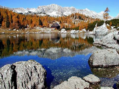 Veliko Spicje from 7 Triglav lakes valley Veliko Spicje from 7 Triglav lakes valley |
Even a massif that is so beautiful, like Julian Alps, has its special corners. And those special corners have their own special picture perfect spots. One of those can be reached from Savica, a trailhead for the legendary valley of 7 Triglav Lakes. After surmounting steep sides of Komarca and long Lopucniska Dolina valley, whose forests hide any view of distant mountains that surround you, suddenly, as forest clears, picture perfect scene opens in front of you. Behind green, crystal clear, waters of Dvojno Jezero lake stands sweet wooden hut. But this panorama would not be extraordinary without the background curtain provided by the beautiful mountain this page is dedicated to. This is Veliko Spicje, irreplaceable piece in the puzzle about one of famous Julian Alps panoramas, a heart of Zlatorogovo Kraljevstvo (Kingdom of golden horned chamois)! Probably there isn’t a single person with camera that doesn’t take the photo of Veliko Spicje from the shores of Dvojno Jezero (Twin/Double Lake) while passing by. But of all that people not many climb Veliko Spicje, as for most 7 Triglav Lakes valley is transit area on the way between Triglav and Bohinj, which makes Veliko Spicje quite a lonely peak. Peak that offers one of most beautiful routes and views in Julian Alps!
 |  |  |  |  |
Overview
 Veliko Spicje - Trenta side
Veliko Spicje or Lepo Spicje (Big or Beautiful Spicje) is the highest peak in the ridge that is placed between two famous valleys; deeply cut Trenta valley on the west and high lying 7 Triglav Lakes valley, on the east. This is the heart of Julian Alps and one of its most beautiful corners, especially famous 7 Triglav Lakes valley above which Veliko Spicje is showing off its best known side.
Ridge is stretching in SW-NE direction, between Velika Vrata (1924m) pass, which divides it from Kal (2001m) group on the SW, and Prehodavci (2021m) pass, which divides it from Kanjavec (2568m) on the NE. Veliko Spicje is placed in the central part of the ridge. Other important peaks are Plaski Vogel (2348m) and Celo (2228m) on the SW and Malo Spicje (2312m) on the NE. Between them are other numerous smaller heads which exceed 2200m. Except being highest of them all Veliko Spicje shares all other characteristics with neighboring peaks in the ridge.
On Trenta side are steep and up to 500m high cliffs. They don’t fall directly into Trenta valley but series of smaller valleys closed by Velika Ticarica (1892m) and Zadnjiski Ozebnik (2083m). These valleys are Trebiski Dol and Ravni Dol, places of rich flora which very few people visit. Through Trebiski Dol leads the marked path from Trenta valley to Prehodavci, which is one of two trailheads to visit Veliko Spicje.
On the 7 Triglav Lakes valley side ridge falls with less steep cliffs, which are made of characteristic horizontal ledges and grassy terraces between them. Below the cliffs are scree slopes and further below torn karst world with bushes of dwarf pine and lonely larch trees.
 Veliko Spicje from Komna plateau
When was Veliko Spicje first climb is probably unknown but it is known that the first person to climb its west face was Henrik Tuma in 1913. Advanced hikers/mountaineers can today use his route (Tumova smer, Tuma route) as an alternative (adrenaline) approach. Difficulty is I-II. To access this route go from Trebiski Dol to Cez Drt pass and to Griva (1804m) head at the foot of the face. Exit of the route is on the ridge, just NE of the summit.
Other climbing routes are:
~ Centralni steber (Central Pillar), IV, 500m. Reaches the very summit.
~ Kamniska smer (Kamnik Route), III, IV.
From Griva (1804m), entrance into Tuma route, tour ski descent is also possible. It leads down the Ravni Dol and Dol pod Plazmi valleys. This is one of the recommended tour ski routes in the area and you’ll find it on the maps as blue line.
Views from the summit of Veliko Spicje are fantastic! On the east and south is valley of 7 Triglav Lakes. Far on the south, behind green Komna plateau, is Southern Bohinj range. On the NE Kanjavec and Triglav dominate. On the north and west are depths of Trenta valley and whole parade of most of the highest peaks of Julian Alps.
More about the area and 7 Triglav lakes valley find on Bohinj group page
 |  |  |  |  |
Routes
 In 7 Triglav lakes valley
Veliko Spicje is accessible from two directions. Trailheads are Koca pri Triglavskih Jezerih (hut in 7 Triglav lakes valley) and Zasavska Koca na Prehodavcih (Zasavska hut on Prehodavci pass).
Reaching trailheads
~ Hut in 7 Triglav lakes valley is usually approached from Bohinj valley via Komarca and Crno Jezero lake. It lasts 3.30h. Description of the route is here.
~ Hut on Prehodavci pass is usually approached from 7 Triglav lakes valley hut (2.15h). Less frequently used are two approaches from Trenta valley. One leads through Zadnjica valley (3.30h) and the other through Trebiski Dol valley (4.30h).
 Concentric beauty
To Veliko Spicje
~ Trail from Triglav lakes hut leaves the main path, which heads north through the valley towards Prehodavci, after some 30mins. Over the karts terrain it gradually gains altitude till it reaches the foot of Spicje. From there it ascends steeply till the ridge near the summit. On few places trail is secured but there is nothing serious about it. From the hut to the summit it takes 2:30h.
~ Trail from Prehodavci hut mostly follows the ridge to the summit, except in the very beginning. There are some ups and downs on the ridge, between peaks. Trail is secured on some places but there is nothing serious about it. Views along the way are fantastic upon both valleys and on numerous peaks. From the hut to the summit it takes 2:30h.
Trails are beautiful so it is recommended to do both, either as a circular trip from one of the huts or on the way between them.
Getting There
 Spicje ridge from Trenta valley
Approaches to Veliko Spicje are leading from Bohinj or Trenta.
Slovenian capital Ljubljana is the heart of the country and its main gateway. If you want to reach Ljubljana by plane look for timetable on the site of Adria Airways, a national airline. For train time schedules see Slovenian railways or German railways sites.
From Ljubljana you need a car to reach Bohinj and Trenta or you can use bus service. Buses towards Bohinj depart from Ljubljana every hour. Trenta valley is connected with Ljubljana by bus only in summer season via Vrsic pass.
From Ljubljana via Bled and Bohinj it is 85km to Savica trailhead at the end of Bohinj valley.
From Ljubljana via Kranjska Gora and Vrsic pass it is 109km to Trenta village in Trenta valley.
Maps
Recommended maps:Julijske Alpe, vzhodni del 1:50000 (Julian Alps, eastern part)
Julian Alps, Triglav 1:25000
Trenta - Triglavski narodni park 1:25000. Planinska zalozba, No. 110
 |  |
When to Climb
Usual time to climb Veliko Spicje is snow less period between June and end of October, although one has to have in mind that snow fall is possible all year. Most interesting months in this period are June and July because of flowers and fresh greenery, especially June, and October, which is probably most beautiful month, because of golden larch trees in 7 Triglav lakes valley.From November to June Julian Alps are under snow. Usually in November there isn’t much snow so non technical climb is still possible then but that depends from year to year. From December to May there are meters of snow in the area. Veliko Spicje is then quite far, especially if snow is in powder condition. Then there is risk of avalanches on the slopes of Veliko Spicje. Full winter equipment is necessary and this is only for experienced mountaineers.
Mountain Conditions
Mountain conditions in Julian Alps are well known thanks to Kredarica (2515m) hut and meteo station, which is just below the Triglav (2864), highest peak of Julian Alps.Best overview of daily data values is provided by Russian Weather Server -> Kredarica @ Infospace.ru
You can also observe current conditions and forecast for Kredarica on the Wunderground meteo site.
Wunderground - Kredarica page.
Current weather and forecasts can also be found on the Slovenian Environment Agency pages.
Direct link to Current Conditions page
Direct link to Snow Depth page
You can also check current conditions, weather overview and history Triglav page
Huts
Koca pri Savici (653m) (Hut near Savica) stands in the beech forest, at the bottom of glacial cirque Komarca and its cliffs. This is the beginning of Bohinj lake valley. It is accessible by car from Bled, via Bohinj (36km). Parking is not free. Opening year was 1951 after the renovation of previous Yugoslav border watch-house. Vicinity of Savica waterfall made it very popular tourist hut so in 1990 it was enlarged. Hut is open from beginning of June till end of September. It has electricity, hot water and 32 beds.Dom na Komni (1520m) (Hut on Komna) is placed on the edge of vast Komna plateau, above the Bohinjsko jezero lake basin. It was first built by Slovenian mountaineering association and opened in 1936. In 1941 it burned in WWII. After the war Ljubljana-Matica rebuilds and opened it in June of 1948. It was then renovated in 1952. In 1964 freight cableway was built. In 2004 hut was completely renovated so currently it is like brand new. It has 120 beds, warm water, central heating and all the beauties of civilization and is open ALL YEAR!
Koca pri Sedmerih Triglavskih Jezerih (1685m) (Hut on Seven Triglav lakes) stands on the shore of Dvojno Jezero (Double or Twin Lake) in the valley of 7 Triglav Lakes. North of the hut is Mocivec artificial lake. It was built by Austrian Tourist Club in 1880. Ljubljana-Matica mountaineering club took it over in 1919. In 1955 it was significantly enlarged and again in 1988. By the hut is small winter room house. Hut is open from the end of June till the beginning of October. It has 200 beds in rooms of various sizes but is often very crowded. Winter room has 18 beds. Has cold water and electricity from generator. It is beautifully placed, just by the lake and has beautiful views on the cliffs and peaks around.
Zasavska Koca na Prehodavcih (2071m) (Zasavska Hut on Prehodavci) stands on Prehodavci pass, between Spicje and Kanjavec mountains. On the east is 7 Triglav Lakes Valley while on the west is Trenta valley, deep bellow. It was opened in 1954. In 1973 enlarged hut was reopened. In 1987 it was readapted. It has 55 beds, cold water, and power generator. View from the hut is fantastic. Hut is open from beginning of July till the end of September. It has winter room.
Camping
Camping inside the National Park is forbidden. Beside the numerous mountain huts around Mojstrovka there are plenty of hotels and private apartments in the towns and villages, which surround the area. Here are few links where you can find info on accommodations closer and further away:Bohinj
Trenta.
Kranjska Gora
Mojstrana
Bovec
Red Tape
 Kranjski Ljiljan
Veliko Spicje is in the Triglav National Park but there is no entrance fee. Usual rules that go with every national park apply here.
Vid Pogachnik - Jun 6, 2006 9:11 pm - Voted 10/10
Two extreme ski descentsSasa, for mor complete information, you can perhaps add in Overview chapter below tour skiing text this: In optimal conditions Tumova route and the neighbouring Skrita diagonala (Hidden Diagonal) route can be done also with skis. Passages are up to 50 degrees steep (in both routes), the alpinistic ski rating is: V+, passage S6, very exposed in the upper part.
Velebit - Jun 7, 2006 4:28 pm - Hasn't voted
Re: Two extreme ski descentsNo problem Vid, I'll add everything.