
-
 9767 Hits
-
 85.12% Score
-
 20 Votes
|
|
Mountain/Rock |
|---|---|
|
|
42.83531°N / 0.3302°W |
|
|
Mountaineering |
|
|
9265 ft / 2824 m |
|
|
Overview
The peak Arriel is the first one great mountain to the East of the step-crossing of the Portalet a little darkened by the pretty and highest presence of mountains as Balaitous, Frondiellas or Pallas, but its sharp granite form gives a wild and inaccessible aspect that stimulates the mountaineers.
There are mountains situated in incomparable places but that are overcome in height and beauty by very nearby others for what often they happen unknown among the mountaineers and this is what happens with the peak Arriel, an important and wonderfull mountain in the valley of the first three-thousands (Frondiellas, Facha, Picos del Infierno, Garmo Negro…) and the legendary Balaitous. Many persons who approach for the first time to this zone attracted for the Balaitous, they discover from his summit the impressive image of other two big and nice mountains towards the north, the peak Arriel (2860m) and the peak Pallas (2975m) forgotten by the collectors of three-thousand.
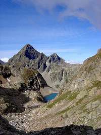
 Arriel and Arremoulit
 Peaks of Arriel
After several visits to the zone it is frequent to begin asking for this mountain and the routes of ascension, and the first thing on that it is necessary to comment is that the access is not habitual from Respumoso's refuge (his impressive east face and his very long route to border on it, it prevent) and that must be ascended for his proper route from the Dam of La Sarra (Spain) or Cabaine de Soques (France).
The normal route is not excessively complicated (degree I +) but there is not exempt from risks in the exposed final ridge of summit that it must be attacked in the best climatological conditions. The route is more confused and less traveled that the rest of mountains of the zone and the use of a map and a good sense of orientation is very advisable.
Another name is some spanish maps: Pico Saldiecho.
 |
 |
 |
 |
 |
Getting There
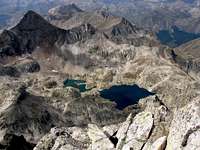
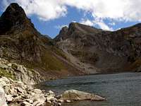
 La Sarra
 Lake Arremoulit
-Spanish Trailhead: embalse de la Sarra (La Sarra's dam)
Nearest village: Sallent de Gallego.
Approach to Sallent de Gallego:
-From North and West of Spain, N-240 to Jaca, N-260 and A-136 to Biescas, turn to right 5 km to Sallent.
-From South (Huesca, Zaragoza, Madrid…), N-330A to reach N-260.
-From East (Barcelona, Lleida..), N-240 to Barbastro and Huesca to reach N-330A and N-260.
From Sallent to La Sarra take the bad road for 6 km to the dam.
-French Trailhead: Caillou de Soques (1392m)
The approach is possible from Pau (France) and Port of Portalet (Spain).
-From Portalet (1794m) we descent the road D-934 for a few of km to reach the little parking under the ridge of Arrious-Soques.
-From Pau follow the road in diretion south to Arudy, Laruns, Eaux-Chaudes and Fabreges. After the dam of Fabreges we reach the parking. Near of this area is the station of turistic train of lake of Artouste.
Red Tape
No permits required. Not allowed the free camping.When to climb
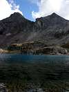
 Arriel & L.Arrémoulit
Summer is the best option (july-september).
In winter is a exposed climb. Early in the season (may-june) is very changeable each year but generally is possible many days with technical material (crampons and ice-axe), but it’s advisable don’t climb in cold days (ice in the ridge) because the fall of north face is terrible.
Camping
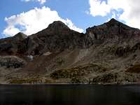
 Arriel & Lake Arrious
Not camping allowed except at 2 hours of walk of some refuge; you must to dismount the tent in the morning.
Spain:-Refugio de Respumoso (FAM, 98 places, april-december, tel: 974 490203). Is possible the climb from there but really is not necessary the night in the refuge except if you want to climb anothers mountains as well.
France:-Refugio Arremoulit (CAF de Pau, Tel : 05 59053179), good option if you trailhead is in french side but really is not necessary, the full climb in one day is perfectly possible and the normal route don’t cross for the hut.
Weather conditions
See in I.N.M. at the north of province of Huesca
External Links
PirineodeAragoninteresting collection of pictures of route of Arriel from Arrious (C. de Soques).
Mendiak
route from La Sarra (text is spanish) with good images and sketchs.