
|
|
Mountain/Rock |
|---|---|
|
|
40.77150°N / 111.8085°W |
|
|
Salt Lake |
|
|
Hiking, Scrambling |
|
|
6561 ft / 2000 m |
|
|
Overview
Red Butte is a steep foothill just behind the University of Utah campus, located near Red Butte Canyon and the Red Butte Botanical Garden. There are several ways to hike it, but the closest to the city (and the University of Utah campus) is from the end of Wakara Way. It looks innocent enough from the trailhead, but it rises over 1,500 feet in just over a mile, and has about 3 or 4 false summits. Red Butte is an excellent short hike to do while in Salt Lake City or while visiting the University of Utah.The hike itself it a maze of trails at the bottom, and steep hiking to light scrambling once up on the summit ridge. The mountain is very steep, with nearly vertical gullies coming down from the numerous summits. Hiking requires lots of water, and a couple hours to spare. The views of the top include Mount Wire and other surrounding foothills. You can see several major Wasatch peaks along the way. However, the most fantastic views are those of the University and of downtown Salt Lake City, more than 1500 feet below. In the distance (towards the West) you can see the Great Salt Lake and the Oquirrh Mountains. This is a fantastic spot to view the glorious Western sunset.
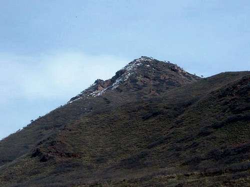 Red Butte from start of the trail
Getting There
The University of Utah is located in the Eastern part of Salt Lake City. From the I-15, take the 4th south exit and continue east through downtown, up past the University of Utah, and turn left (east) on Wakara Avenue. From downtown, you need to get onto rt. 181 (1300E. St.) and turn left on rt. 186 (Foothill Drive) until you reach Wakara Way (where you take a left to the University of Utah campus). Once on Wakara Way, drive to the end of the road and park, or drive up to the Red Butte Garden and Arboretom where additional parking is available. Up the road to the Arboretom (before the parking area), you will see the beginning of the trail on the right. You follow a red trail up through a maze of trails. Continue up towards the mountain. You will end up hiking up to a ridge to the right of the mountain, in between Red Butte and a smaller summit. You will head towards the summit, and navigate over about 3 false summits. Once on the ridge, it is about 20 minutes to the top. The trail isn't always clear, but because the mountain is open, getting off trail will not get you lost. Overall, it takes about 30 minutes to an hour to reach the summit, depending on the weather and if there is snow on the ground. To get to the George's Hollow Trail, turn right on Coldrow Avenue at the end of Wakara Way and go south. Head down the road until you see a sign, just before the Huntsman building. Park along either side of the road where you can access the the George's Hollow Trail (slightly longer than the main trail described above).See links below for directions to other trailheads.
Red Tape and When to Climb
There are no permits required for the standard trail at the end of Wakara Way. Just park your car and hike up to the summit. Red Butte can be climbed all year round. Beware of icy conditions in winter because of the loose rock. Beware of overgrowth in the summer and watch where you step as you might run into snakes or spiders.External Links
TrailsRed Butte Trail
Shoreline Trail
George's Hollow
Red Butte Botanical Garden home page
Red Butte Canyon Natural Research Area
Weather
Additional Information
Red Butte is located southeast of Mount Van Cott and northwest of MountWire (Big Beacon).
Red Butte Canyon is situated along the northern side of Red Butte. It
contains about 5,370 acres of land. The western boundary is almost
immediately east of the University of Utah campus, in Salt Lake City. The
canyon was a protected watershed for Fort Douglas, the U.S. Army post that
overlooked Salt Lake City. These lands were, for the most part, kept free
from grazing, farming, and other human activities. The Forest Service
designates and manages this special area. It is permanently protected and
maintained in natural conditions, for the purposes of conserving biological
diversity, conducting research and monitoring, and fostering education.
The area was initially affected by human activities during the early
settlement of the Salt Lake Valley, the canyon was soon set aside by the
federal government and has now had nearly a century to recover. Prior to
the run-off of 1983, the riparian habitats were much more extensively
developed than at present. Numerous marshy meadows existed in association
with large active beaver dams prior to 1982. The loss of active beaver
dams in the early 1980s has doubtless greatly reduced the populations of
small mammals that are restricted to the mesic-marshy habitats of the
canyon. The area around Red Butte is characterized by foothill and
mid-elevation plant communities including oak-maple, aspen, riparian, and
Douglas-fir communities.
Red Butte Reservoir was built in 1930 as a water supply of Fort Douglas
at the base of Red Butte Canyon. After 55 years, the fort switched to
municipal water supply from Salt Lake City. Until recently, the reservoir
was on federal ownership and was managed by the United States Forest
Service as part of a protected research natural area. In 2004, the
ownership and management responsibility for the reservoir was transferred
to the Central Utah Water Conservancy District. The reservoir, which
covers about 10 acres, is fed by Red Butte Creek. Under current management,
the reservoir’s maximum depth is 34.5 feet but fluctuates throughout the
year between 31 feet and 39 feet.
Red Butte Gardens is the most well known feature near the mountain. It
has 150 acres of gardens, hiking trails and walking paths. Red Butte is
considered the largest botanical and ecological center in the Intermountain
West that tests, displays and interprets regional horticulture. Visitors
will find a 1,500-acre arboretum housing 9,000 specimens of trees and
shrubs from around the globe on the University of Utah campus. The
nonprofit organization dates back to 1931, with original plantings by the
former chairman of the university's botany department, Dr. Walter P.
Cottam. The current entrance fee is $5.00.
Thanks to mountaingazelle for this information.
hgrapid - Mar 25, 2006 11:30 pm - Hasn't voted
Re: Looks goodDone
Scott - Mar 27, 2006 4:43 pm - Voted 8/10
A few corrections1. Oquirth Mountains is really Oquirrh ("Oak-er") Mountains on the page and in the photo captions. Don't ask me where they (map makers) got that spelling! 2. Perhaps mention that this is really a sub peak/ridge of Big Beacon/Mt. Wire rather than a seperate mountain. 3. "Addition Information" looks a bit screwy on my computer. Perhaps eliminate some spaces to make it a text block? Other than that it looks good. Too bad it wasn't sunny for you.
hgrapid - Mar 27, 2006 5:16 pm - Hasn't voted
Re: A few correctionsThanks Scott. However, Red Butte really wasn't a ridge of Big Beacon/Mt. Wire. It was far separated from Mount Wire, and there was no connecting ridge to speak of. I will make the changes.
Scott - Mar 27, 2006 9:08 pm - Voted 8/10
Re: A few correctionsHowever, Red Butte really wasn't a ridge of Big Beacon/Mt. Wire. It was far separated from Mount Wire, and there was no connecting ridge to speak of. Hmmmm, hate to disagree, but actually it is, in fact it is part of the second most popular route to Mount Wire-the Georges Hollow loop route. The summit of Red Butte is actually the northern most closed 6600 foot contour. There is only a 20 foot saddle between Red Butte and the northwest ridge of Mount Wire, and Red Butte is part of that ridge. See the map (the x is the summit of Red Butte): Topozone