
-
 16804 Hits
-
 79.04% Score
-
 10 Votes
|
|
Mountain/Rock |
|---|---|
|
|
37.08050°N / 118.69122°W |
|
|
Hiking, Mountaineering |
|
|
Spring, Summer, Fall, Winter |
|
|
12939 ft / 3944 m |
|
|
Overview
Scylla. Not Scylla Peak or Mt. Scylla or any other adornment, just Scylla. In Homer’s Odyssey (which was not written by Homer but someone by the same name), our hero Odysseus must navigate between two monstrous piles of rock, each with its own nightmarish fate. On one side is the Charybdis, a mutated nymph that sucked water in and forced it out again three times a day. On the other is Scylla, with twelve feet and six heads, each one with three rows of teeth. While trying to navigate between them, sailors are lured to their death by the song of the Sirens, so tempting in its beauty and meaning that men will follow it to their end.And so it was, that while navigating the area in the late 19th century, heading from the Ionian Basin into the Enchanted Gorge, Solomons and Bonner noted that they were passing between the hulking, looming towers of rock, Charybdis and Scylla, and so they are named on our maps. The craggy towers just below Scylla are appropriately called the Three Sirens.
 Scylla and Charybdis
Getting There
Scylla is isolated. Although I do not doubt the capabilities of some dayhikers, this would be one hell of a day hike. Note: proving my prediction from those links back in 2006, Scylla has been day-hiked at least three times. Future edits will include their routes. Scylla is well west of the Sierra Crest, and can be accessed from the east or the west. Due to many quality peaks in the area and on the approaches, a long visit here can be quite productive. Scylla Driving Approaches
From the west
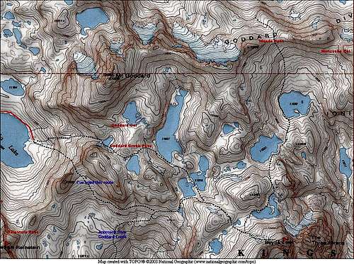
A popular approach from the west begins at Florence Lake, where one can hike or take a ferry across the lake. If you don’t mind the less than alpine start, grab the first ferry boat across and save about 4 up and down miles. From the south end of Florence Lake, follow the main trail beyond Blayney Meadows to the JMT/PCT. Follow the PCT over Piute Creek and into Kings Canyon National Park to Evolution Junction. Leave the PCT and continue up the San Joaquin to Martha Lake on an unmaintained but well-trod trail. I’ve met some hikers that use Hell for Sure Pass and drop into Goddard Canyon at this point. From Lake Martha I’ve crossed the saddle ESE of Lake Martha, between Peak 12,432 and Peak 12,640+. The crossing is easy enough, but traversing the bowl after it was a tad trying. The Goddard Peak Pass approach described by Secor looks to avoid the sidehilling: ascend to the small lake east of Lake Martha then go southeast to the north shore of Lake 12,000+, drop to Lake 11,951 and cross Lake 11,818 where the peninsulas touch. If you’ve made this crossing, I’d love to hear about it.
 Lake 11,818
From the east
Access from the east involves more gain and loss of elevation, but gives back in speed. If you are day hiking or doing some other version of light-and-fast, this may be your choice. If you are lugging a full pack for several days, you should check the distances and elevations gains for the passes.
Check Matthew Holliman's Eastern Sierra Logistical Center for information on all the eastern Sierra trailheads, including North, Sabrina, and South Lakes.
Lamarck Col
From the east, head out of North Lake to Lamarck Col. Drop through Darwin Canyon to the PCT and then ascend toward John Muir Pass. Wanda Pass would work, but Bob Burd selected Secor’s Nietzsche Col into the Ionian Basin, which does appear more direct than Wanda for the purpose of accessing Scylla.
Echo Col
One can also access the Wanda Pass coming over Echo Col and Muir Pass, but Secor’s Nietzsche Col will be more direct.
Accessing the Ionian Basin by way of Black Giant Pass (and some other Crest pass south of Muir Pass) with the intent of summitting Scylla does not look fun. This is one of the ways to access Charybdis, but it doesn’t look good for Scylla due to the unnecessary decent into lower lakes of the Ionian Basin. Use of Wanda Pass will keep you higher. If you are coming up the JMT from the south, I think it looks better to lump it, go over Muir Pass to the north, and traverse to Wanda Pass. This will give you a more direct path through the basin in addition to keeping you higher.
Hungry Packer Pass
Looking forward to information from Bob Burd, who used Hungry Packer Pass on his dayhike return from Scylla.
Red Tape
If you’re spending a night on the trail (and you almost certainly will be), you’ll need a backcountry permit. As Dave Daly mentions on his Charybdis page, you need a permit for your entry point, which is most likely not going to be the national park but rather one of the national forests. If you’re coming from any of the reservoirs on the west side, that’s likely the Sierra National Forest. Entry points on the east are likely through Inyo National Forest. Be aware that current (2006) National Forest policy does NOT allow for "drop box" (after-hours) pick-up of permits if you are camping in Kings Canyon National Park. That potentially means an extra day just to pick up the dang permit, so plan accordingly.Camping
See Red Tape above for required permits for overnight stays. Coming from Lake Florence, there are numerous beautiful campsites along the San Joaquin from Evolution Junction up to Lake Martha. Lake Martha is a little exposed to the wind, so we camped a few hundred feet below without incident. Camping in the Ionian Basin itself may be rough, rocky existence, but there’s a chance you could eke out a spot on a flat boulder along one of the lakes.External Links
Matt Worster's Trip Report from Florence Lake August 2004Steve Eckert's trip report from Courtwright Reservoir (from climber.org)
Bob Burd's dayhike over Lamarck and back through Hungry Packer Pass. September 2010
If you have a trip report with alternate approaches, let me know!
Bob Burd - Feb 18, 2011 4:07 pm - Voted 10/10
Haeckel Col"Looking forward to information from Bob Burd, who used Hungry Packer Pass on his dayhike return from Scylla." Secor calls it Haeckel Col. The route was certainly better (faster) than Lamarck Col, though not as straightforward. After reviewing all the possible eastside routes to Scylla, we concluded that Echo Col -> Muir Pass -> Nietzsche Col is undoubtedly the fastest way to reach it. Would have saved many hours if I'd realized this beforehand...