
-
 11705 Hits
-
 88.95% Score
-
 28 Votes
|
|
Mountain/Rock |
|---|---|
|
|
40.78570°N / 110.4903°W |
|
|
Hiking, Skiing |
|
|
12990 ft / 3959 m |
|
|
Overview
 The bow of the plateau
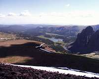
Squaw Benchmark, just a few feet short of the magic 13,000 level (and the 10th highest officially named high point in Utah), is centrally located amidst the semi-circle of Western-most Uinta 13'ers, from Powell to Tokewanna. The summit is techically easy but quite remote. Perhaps the most distinctive feature of this otherwise tame-looking peak is a spectacular 1000-ft dropoff from its NE Bench plateau into the beautiful Red Castle Lake.
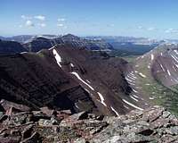
 Red Castle, not from the usual angle
In summer, the Red Castle drainage is teeming with backpackers and campers, drawn to the single most iconic view of the entire Uinta Range, the reflection of Red Castle Spire in the lower lake. But hardly any of these people venture beyond the valley bottom. On the way to Squaw, solitude is virtualy guaranteed.
There is a certain degree of confusion about the name of the peak, since there is another Squaw Peak, almost as high, barely a dozen miles to the South-West. In order to clarify the things, I will refer to "this" Squaw Peak as "Squaw Benchmark" or "Squaw BM".
Getting There
The nearest (and highest starting elevation) trailhead is at East Fork Blacks Fork TH, accessible either from Mtn View or from Mirror Lake Highway over Elizabeth Pass. A third way to get here, from Exit 30 on I-80, is described on Tokewanna page; I haven't seen it recommended anywhere alse and can't vouch for the quality of county and forest roads there. Bear River - Smith Fork trail crosses the N Ridge in the timber country
From Mountain View, bear right (W) at the Elk Junction towards Robertson (8 mi). Continuing West from Robertson, the blacktop crosses Smith Fork and Blacks Fork rivers. Take left fork marked Meeks Cabin Reservoir after the Blascks Fork bridge. Pavement soon ends, but the road remains reasonably well plowed to the state line. Once it crosses from Wyoming to Utah, the becomes a bad washboard, only to get even worse past the concrete bridge over West Fork. Allow at least one hour for the unpaved ca. 20-mile section of this road.
The same concrete bridge is accessible from Bear River Lodge area on Mirror Lake Highway by North Slopes Road (about 25 miles of unpaved roads to the TH this way). The North Slopes road afords great views to the mountains but its 10,300 ft Elizabeth Pass may remain imapassable well into early summer.
 Smith Fork valley, seen from the summit
Please note that there actually are two close-by trailheads in East Fork. A posted Smith Fork - Bear River trailhead is about 0.7 miles short of the road's end. To continue East to Bald Mtn Trail, one would have to ford East Fork here, which is almost never the best option. The other TH, at the end of the road, has a bridge over the river. It serves East Fork Blacks Fork Trail, and a connector trail turning left some 100 yards after the bridge (right after the trail crosses a small tributary on logs). The connector feeds into a Smith Fork trail in three quarters of a mile. Since it starts kind of in a wrong direction (going South for the first 100 yards or so), hikers may be tempted to shortcut North towards Smith Fork trail over an open meadow. Don't do it, the meadow is marshy as it often happens in the Uintas. Spare the vegetation, and keep you feet dry, by using the designated trail.
 Squaw Pass and Oweep Valley beyond
Smith Fork TH is accssible from Elk Jct in Mtn View. Take Robertson Road West, stay straight when the paved highway makes its second 90-degree right turn (graded Forest Road continues straight South). This road is plowed to the Henrys Fork junction in winter.
The South side of Squaw BM overlooks the headwaters of Oweep Creek, and Highline Trail. This side is quite a bit further away from the trailheads.
Routes Overview
 Lake 11,470 in the foreground - NE Buttress route
Kelsey suggests ridgeline routes from the SE and SW, from the saddle separating Squaw from Wilson above Upper Red Castle Lake and from Squaw Pass, respectively.
My experience is limited to Northerly approaches, which all converge on the North Saddle 12,390.
 West Gully, and the summit to the right
NE Buttress is separated from the NE Bench Plateau by a deep gully draining from the N Saddle. Leave Red Castle trail soon after the Lower Red Castle Lake, and pass North of Lake 11,470, gaining the ridge just North of the Saddle.
West Gully connects North Saddle with Little East Fork and Squaw Pass trail near the timberline. As the trail leaves the valley bottom and begins a 300-ft climb on a minor ridge between Little East Fork and its tributary, look for twin krummholtz-lined gullies. Ascend along the gullies to the NE to North Saddle.
 N Saddle and N Ridge
Direct North Ridge route leaves Bald Mtn trail near Bald Mountain, crosses a wide tundra saddle to its South, and ascends a wide ridge to Hill 12,790, which is the highest point on the ridge. Further South, numerous minor summits and steep but short drops goard the way to North Saddle.
 E Bench of N Ridge
East Bench of North Ridge is another above-the-timberline variation, which avoids most of the altitude loss inevitable on the Direct Ridge route by descending from the ridge at the South side of Bald Mtn Flats, dropping about 200 vertical ft to a an uneven 11,500 ft bench. A small but steep corniced spur ridge needs to be crossed on the right (West) side. In the vicinity of North Saddle, the route merges with NE Buttress route.