
|
|
Mountain/Rock |
|---|---|
|
|
48.53330°N / 120.65°W |
|
|
Mountaineering |
|
|
Spring, Summer |
|
|
7560 ft / 2304 m |
|
|
Overview
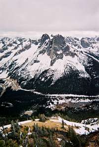 Liberty Bell and the Early Winters Spires from Hinkhouse Peak
The summit of Hinkhouse Peak is near the east end of a ridge running 2-1/2 miles eastward from Cutthroat Peak. This ridge serves as the border between Okanogan and Chelan counties. From the summit, Liberty Bell and North and South Early Winters Spires dominate to the south, and Kangaroo Ridge and Silver Star the east. West along the ridge is Cutthroat, and across the Cutthroat Creek drainage peaks stretch northward into Canada. The first ascent is attributed to Lage Wernstedt in 1925 or 1926. Wernstedt was an Associate Topographic Engineer for the US Forest Service.
The mountain has been identified through the years by a number of unofficial names including Washington Pass Peak, and Fickle Peak, and the four crags at the summit are known as The Towers of the Throatgripper. Most recently it was identified in Beckey’s Cascade Alpine Guide: Rainy Pass to Fraser River as State Crag. The most recent edition of Beckey's Cascade Alpine Guide: Columbia River to Stevens Pass erroneously identifies a peak in the Teanaway/Mt. Stuart area as Hinkhouse Peak. See the "NOT Hinkhouse Peak" section below for more about this case of mistaken identity.
Getting There
 Going early in the spring provides relief from the bushwhacking down low and loose talus higher up.
 Class 4 drop to the notch between the "Index" and "Fickle" crags
Hinkhouse Peak is located immediately north of the Washington Pass overlook just off Highway 20 (the North Cascades Highway) about 42 miles east of Newhalem WA or 31 miles west of Winthrop WA. Please note, the USGS topo map does not show the North Cascades Highway through Washington Pass, so don't be surprised if you use the topozone.com link on this page and don't find the road!
No trail goes up Hinkhouse Peak. An ascent of the mountain’s south slope begins across the meadow 2100 feet below the summit at the turnout for the Washington Pass Overlook, following any of the several shallow ravines through minor patches of bushwhacking and scree scrambles to reach the ridge. The previous link provide a "virtual reality" photographic view from the overlook. The view through the trees provides a glimpse of the NE ridge of Hinkhouse Peak, which is east of the more frequently used gullies to attain the summit.
The approach to the summit towers is blocked by a short drop to a notch, which can be down-climbed, rappelled, or (if snow-free) avoided by traversing a ledge on the northeast side of the first high point. The final pitch to the true summit is a rope length of class-four scrambling up a blocky ridge.
The peak has also been climbed from the horse camp on Cutthroat Creek to the north, and by following the ridge all the way eastward from Cutthroat Peak.
Red Tape
The typical (south) approach to the summit is across land designated as part of the North Cascades Scenic Highway, and thus no permits are required. The less frequently used approach from the north is in the Okanagan National Forest and also requires no permit.Camping
Camping is available at a number of National Forest Service campgrounds along Highway 20 in either direction from Washington Pass.Okanogan National Forest campgrounds on Highway 20 east of Washington Pass. Lone Fir is the closest campground in this direction, 5 miles east of the Pass. The larger Klipchuck Campground is 6 miles further east.
External Links
 Klenke's panorama from Silver Star, with Hinkhouse Peak identified in foreground
 Klenke's photo of Silver Star, with Hinkhouse Peak in foreground, from Cutthroat
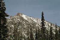 Hinkhouse Peak from the west
Refer to A History of Hinkhouse Peak in Issue 2, June 2005, of the Northwest Mountaineering Journal for more on the history of Hinkhouse Peak and a little about the man for whom it is named.
Refer to the OSAT Home Page for information about the climbing organization conceived of and founded by Jim Hinkhouse.
Official Washington DOT Page for North Cascades Highway including Washington Pass WSDOT has a hell of a good webmaster. Their website is maintained in top notch condition, and is very informative. There is a complete history of the winter closings and spring openings of the highway accessable from the site, as well as a wealth of other information.
North Cascades Highway and Pass Conditions Report - The WSDOT does a fantastic job of reporting the progress of getting the road open every spring, including pictures of the work being done.
We have noted that the weather telemetry station is on the south side of the highway, in the shadow of Liberty Bell. Thus, the snow cover on the main slope up south-facing Hinkhouse Peak is typically less than reported by telemetry. CAUTION BACKCOUNTRY SKIERS: On some years the weather station has reported as much as 2 feet of snow when the meadow at the base of the climb is snow-free.
National Weather Service official forecast for Washington Pass If you zoom in on the map, you'll see it now bears the official designation of Hinkhouse Peak!
Washington Online Weather (WOW) forecast for North Cascades includes the Sun Mountain Lodge webcam pointed up the Methow Valley in the general direction of Washington Pass and Hinkhouse Peak from the east.
Northwest Avalanche Center backcountry avalanche conditions and forecast
Official Name Designation
 OSAT club climb to summit in 2004
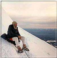 Jim Hinkhouse - high on the Ingraham Glacier of Mt. Rainier, June 1991.
On December 8 2000, the Washington State Board on Geographic Names unanimously accepted the application to name the peak on the north side of Washington Pass Hinkhouse Peak. The location affords as dramatic a mountain vista as exists anywhere in the Cascades -- with a fabulous view of some of the most notable rock climbing peaks in the state. Following the approval in Olympia, the application was sent to Washington D.C., and on June 14, 2001, the United States Board on Geographic Names added its approval.
The name commemorates Jimmy D. Hinkhouse, a Washington state mountaineer in the 1980s and 1990s and founder of the One Step at a Time mountaineering club for members and friends of 12-step recovery groups. His obituary appears in the 1996 American Alpine Journal.
Climbing History
 Summit of Hinkhouse Peak is behind these climbers, the first from OSAT after the peak name was officially designated.
The first ascent of what is now Hinkhouse Peak is attributed to Lage Wernstedt in 1925 or 1926. It is not known if he gave the summit a name. Wernstedt was an Associate Topograpic Engineer for the US Forest Service. The USGS Washington Pass 7.5 minute topographic quadrangle map published in 1963 indicates no name for the peak, nor does the current map distributed by the Okanagan National Forest.
The 1968 Mazama annual register mentions a couple of climbs of “Washington Pass Peak” as it is identified on a map by Jim Nieland accompanying the article by Don Eastman. “Saturday was a day of light, intermittent rain. Its main event was the first of our two climbs of Washington Pass Peak.” Later in the trip Eastman mentions “Our only climbers that day were [Bob] Stites, [Harold] Deery, and Nancy Duckering on Washington Pass Peak.”
The 1971 The Mountaineer climbing notes (p 88) makes reference to a June 1970 climb by John Bousman and Earl Hamilton under the heading “Washington Pass Peak, Towers of the Throatgripper”. “[We] set off on a cloudy, threatening day... after sitting through a day of rain at the newly built horse camp on Cutthroat Creek, impressed by the partial views of a collection of towers to the south of camp. We climbed each of the towers from the northwest. At no time could we see more than 150 feet but the climbing was enjoyable and not very strenuous. From northwest to southeast are Pinky, Ring, Fickle, and Index. Fickle had been ascended by the Mazamas via the south slope in 1968...”
In a Washington state gazetteer, Exploring Washington by Harry M. Majors (1975, (pp. 39-40 ref. No.44) there is reference to the mountain as Fickle Peak, claiming it was first climbed in 1926 by Lage Wernstedt.
In an interview in the fall of 2000, long-time Washington mountaineer John Roper of Seattle said he was with Fred Beckey in the late 1970s when Fred “... pointed up to the peak as we were driving across Washington Pass and noted that it did not have an official name.” Roper recalls Beckey saying something like “Since this is State Creek, I’m going to call it ‘State Crag’.” State Creek runs to the southwest, draining the entire south side of the ridge running from Cutthroat Peak to the Hinkhouse Peak.
On the first climb after the official name was designated, OSAT removed an old Mazamas register, and replaced it with a new register noting the offical naming. The old register was returned to the Mazamas for their archives with an explanation. A letter acknowledging receipt of the register noted "We didn't realize we had a register up there!"
I have a complete transcript of the original register. It contains records of 97 ascents between 1968 and 1999. Dallas Kloke signed the old register 3 times, 3 others signed it twice. The largest party size to sign was 4. Since 1968, no summit climbs were recorded in 9 years, including most recently 1992 and 1996. In no year were there more than 8 names recorded. There is no record of a summit climb between October and April.
NOT Hinkhouse Peak!!
 Peak incorrectly identified as Hinkhouse Peak in Beckey guide
The most recent edition of Beckey's Cascade Alpine Guide: Columbia River to Stevens Pass erroneously identifies as Hinkhouse Peak the highest point on the ridge between Longs Pass and Ingalls Pass in the Teanaway/Mt. Stuart area. The effort to have a peak officially named to commemorate Jim Hinkhouse originally applied for that peak to be so named. However that application was withdrawn at the request of the Washington State Board on Geographic Names.
The summit in question is situated on the boundary of the Alpine Lakes Wilderness. The Board had previous experience trying to establish new names in designated wilderness areas, and found that the US Board on Geographic Names policy against granting names in such areas probably applied to features on wilderness boundaries as well. Evidently the editors of the Beckey guide made their entry on the basis of the original application, not realizing that the applicants were working with the Board to identify the peak in the North Cascades that was eventually approved.
We have written to Mr. Beckey and The Mountaineers explaining the situation and the circumstances surrounding the misunderstanding. Presumably the error will be corrected in any future edition of the guide.
Please Vote!!
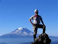 Random spire on the 7500 ft traverse of Gilbert - Mt Adams in the background Photo credit: Andrew
The neat thing about web resource such as SummitPost.org is they are so easy to edit in response to comments or suggestions. Please return to the top of the page and provide a page score on the pages you visit. You may also send a quick note to the authors with ideas on how to improve their descriptions!
Thanks -- Keep Climbing Mountains, and Don't Slip!
eispickel - Jun 4, 2012 9:00 pm - Voted 10/10
Climbing History UpdateThe largest summit party ever to sign the register on Hinkhouse Peak was 12, when an OSAT climb led by friends of Jimmy Hinkhouse summited on June 3rd, 2012.