
-
 7348 Hits
-
 86.85% Score
-
 23 Votes
|
|
Mountain/Rock |
|---|---|
|
|
47.35040°N / 10.91603°E |
|
|
Mountaineering, Sport Climbing, Scrambling |
|
|
Summer, Fall |
|
|
8402 ft / 2561 m |
|
|
Overview
Marienbergspitze is a spectacular double peaked mountain located at the western end of the main ridge of Mieming Range. Although it has rough faces and ridges it is a quite unknown mountain. The reason for this is Grünstein. This neighbour mountain is higher, rougher and more popular. But this results in less ascents and according to the summit log on the higher eastern summit, you' re usually alone on Marienbergspitze.
 Mystic atmosphere...
There are several routes up to Marienbergspitze. Most of them are climbing routes which recommend climibing gear. There are two routes which offer an easy way to the summit. The difficulties are not more than UIAA I and UIAA II in some places. Mieming Range is famous for its fragil rock and therefor the rock quality of Marienberspitze is not the best. But compared to other mountains in the Mieming Range, the rock -especially on the lower part of the mountain- is quite solid. Well, don' t trust your holds too much, its still Mieming Range...
The first ascent of Marienbergspitze is unknown but propably it was the famous Hermann von Barth (1845-1876), which was a great lover and explorer of Mieming Range. In the newer history of the mountain, Goedeke, known from his book "4000er - Die Normalrouten auf alle Viertausender in den Alpen", opened a new climbing route "Der Weg der weissen Schlange" (trail of the white snake, UIAA IV).
Not depending on which way you have chosen to get up there, you are rewarded with splendid views. To the north Wetterstein the impressive south wall of the Zugspitz massif. Lechtal Alps cover the west and the south is build by the glaciers of Stubai Alps and Öztal Alps. To the east Grünstein blocks your views, but causes a beautiful echo.
Maps and routes overview
Maps:
Routes:
|  Great view from Schwärzkar. Great view from Schwärzkar. West ridge West ridge Marienbergspitze west face. Marienbergspitze west face. |
Getting There
| By car: | The best trailhead for Marienbergspitze is Biberwier. This city close to Ehrwald is easily reached by car. In general you have three possibilities to get there. The first one is from Garmisch-Partenkirchen (Germany) via road #187 / #24. The other access from Germany is from Füssen via Reutte (road #314). The third option is use Fernpass (road #314) which connects the area of Ehrwald with the Inntal and its highway to Innsbruck. |
| By train: | There is a trainstation in Ehrwald with train connections to Garmisch-Partenkirchen (Germany) and Schongau (Germany) via Reutte (Austria). If you intend to get to Marienbergspitze by train, you should either consider taking a bicycle with you or ascent via Schwärzkar. The route via Schwärzkar is easy to reach from the train station in Ehrwald -simply follow the street to Ehrwalder Almbahn and from there a trail called "Hoher Gang" leads up to Seebensee and further up to Coburger hut. Biberwier, the trailhead for the southern slopes can be reached by bus, but it only drives on strange times. Because Biberwier is not more than 6km away I would recommend to drive this distance by bicycle. For more information about the train connections visit either DBahn homepage (german trains) or OEBB homepage (austrian trains). |
Summit panorama
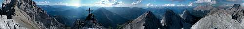 Summit panorama.
Red Tape
There are no permits, fees or seasonal closures.
Parking at the trailhead in Biberwier is free. There is a parking lot at the chairlift. Additionally parking in Ehrwald at the "Ehrwalder Alm Bahn" is free, too.
When to climb
Marienbergspitze is mostly climbed in summer and autumn. On hot summer days don' t forget a hat and bring plenty of water, because the trail becomes very steep and there is nearly no shadow.
During the winter months, Marienbergspitze may be climbed with skies from Schwärzkar and from there by climbing to the summit, but this requires save avalanche conditions, because there is no vegetation and the slopes a steep. Unfortunately the avalanche report of Tyrol is available in german only.
Mountain conditions
Weather:
- www.wetter.com
Precise, but sometimes inaccurate weather forecast for Ehrwald (about 5km from Biberwier). - ZAMG
Not as detailed as the link above, but quite accurate forecasts. - OEAV weather forecast
Weather forecast especially for mountaineering porpuses. Unfortunately this page is available in german only. - Avalanche report (Tyrol/Austria)
As noted before, this german internet page offers the current avalanche report for Tyrol.
Webcams:
 | Webcam of Wannig. Wannig is the closest mountain to the west of Marienbergspitze. |
Camping
Ehrwald is a touristic area with tons of hotels and places to stay. For more information visit the multilangual homepage of the area. Garmisch-Partenkirchen isn' t far away as well, which offers even more hotels.
The only place to stay at the mountain is Coburger hut. From Coburger hut the only way to ascent Marienbergspitze is via Schwärzkar.
Camping on the mountain is not forbidden (as far as I know). I' ve seen several cool spots to pitch a tent on the south slopes of Marienbergspitze...
Page history
| 12/Jul/2010 |
|
| 19/Sep/2006 |
|
| 16/Sep/2006 |
|