
-
 8204 Hits
-
 88.19% Score
-
 26 Votes
|
|
Mountain/Rock |
|---|---|
|
|
46.35069°N / 13.80793°E |
|
|
Scrambling, Skiing |
|
|
Spring, Summer, Fall, Winter |
|
|
8032 ft / 2448 m |
|
|
Overview
 On a ski tour
There's not much to be said about the four summits of Vršaki. Almost nobody ascends them. The highest summit is sometimes ascended by mountaineers, who pass over Hribarice plateau. But as Kanjavec, 2568 m, on the other side of the plateau, offers a far broader panorama, it is understandable that Vršaki are neglected. From the highest summit it is also possible to ski down to Hribarice plateau.
The name Vršaki is written with a caron ('little v') above s and is pronounced 'Vrshaki'. In Slovenian language, 'vršak' is an old, generative name for a summit.
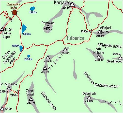
Formally, Vršaki represent the highest point of Bohinj Group. As Bohinj mountains are rising from Bohinj lake towards the north, as their highest point should normally be treated Kanjavec. But it is usually put into the Triglav Group, with the border between the two on Hribarice plateau and Mišeljska dolina (valley). South of Hribarice plateau a labyrinth-like karst world stretches. In summer it is very hardly passable and even in winter you must carefully ski across it, knowing very well the direction. On the NW side, out of this karst a mountain ridge rises, consisting of four summits.
The highest summit of Vršaki is just above Hribarice plateau, the other hree stretch towards the SW. Their NW walls are steep and rocky, they are falling down into the Valley of Triglav Lakes. But as they are not appropriate for solid climbing, nobody goes up over there. The approaches over the SE slopes are quite easy, you scramble up from the high karst plateau. But the approaches there are long and orientation sometimes difficult. On the South, the Vršaki ridge finishes with Globoka konta (= Deep Basin). This is an important orientation point on winter ski tours, as there you need to find a passage down to Laz alpine meadow. On the other side of Globoka konta, there's already the ridge of Vogli, 2327 m.
 North faces North faces |
 From Hribarice From Hribarice |
 From Hribarice From Hribarice |
Routes Overview
 Vrsaki and the surroundings
1. Eastern summit. The ascent route is all seen on the signature picture. From Hribarice we go towards the summit. In the lower part of ascent we detour the rocks of the east ridge by turning left, into the SE slope. A steep, but not exposed slope brings us high below the summit. There we keep left again and ascend over the last steep section (easy rocks) on the southern ridge. By it we reach the summit on the right in a few minutes. In summer conditions the ascent is not demanding (an easy scramble, rated on the Swiss Scale for Hiking tours T3/T4). In winter conditions there is a danger of sliding on steep snow. By the described route it is also possible to ski down. Only the descent over the steep upper passage is demanding, the rest is fairly easy.
2. Traversing all four Vršaki summits. From the eastern summit we don't continue by the connecting ridge, but carefully descend by screes towards the south (rocks below). Then we traverse towards the right and start ascending the middle summit, 2424 m. From it we continue to the third summit (Vrh nad Koritami, 2422 m). The distance to it is a bit bigger, the final ascent again a little steeper. On the third summit the ridge starts turning towards the south. We follow it to the southernmost summit, 2431 m. From Hribarice till here it is some 2 hours of walk.
Below the NW faces of Vršaki a marked path goes from below Hribarice on Vratca pass, 2190 m , and further down to Za Kopico valley. This passage is also used in times of tour skiing, but requires good conditions (usually hard snow, steep slopes).
Tour skiing. I did the skiing from the highest summit of Vršaki. Just on top there was a steep, at that time also a bit rocky passage, where some sliding was needed, the rest below was easy. I believe, that also the other summits can be done with skis. Only that nobody does that, because everyone goes on the far more rewarding summit of Kanjavec. The southern summit of Vršaki however has an appealing east face.
From the Valley of Triglav Lakes you can ascend the Vratca pass - between Zelnarica and Zadnji Vogel. The aim is to ski further down on Bohinj alpine pastures. This passage traverses the steep NW slopes below Vrsaki walls. As these slopes are oriented towards the NW, usually on a morning ascent the passage is hard and requires a full winter equipment. Below the SE slopes of Vršaki you can easilly ski from Hribarice (for example on a Kanjavec ski tour) down towards the South. So you reach Globoka konta, from where you proceed on Laz meadow.
Getting There
 Bohinj group
For the broader overview, see the Julian Alps page and the Bohinj Group page!
In Bohinj valley we arrive by car, bus or train from Bled (by train also from Gorizia). From the main Bohinj valley (Stara Fužina village) we can drive by car towards north into Voje valley. After 2 km there's a crossroad, where we take the left forrest road. It takes us through Suha valley to Planina Blato (alpine pasture), 1147 m. There's a big parking place. In summer, the road through Suha valley needs to be paid.
Maps:
Julijske Alpe - Vzhodni del (Eastern part). Planinska zveza Slovenije. 1:50.000
Julijske Alpe - Triglav. Planinska zveza Slovenije. 1:20.000.
Red Tape
The mountain is in the Triglav National Parc. In summer, for the road from Voje valley trough Suha valley up to Blato alpine pasture you should pay toll.
Huts and Camping
The nearest huts are:
- Koča na Planini pri Jezeru, 1453 m, (041)901 999, (050) 632738,
- Zasavska koča on Prehodavci Pass, 2071 m, Tel.: +386(0)50 614781 +386(0)41 844776,
- Vodnikov dom on Velo polje, 1817 m, +386(0)51 607 211,
- Koča pri Triglavskih jezerih, 1685 m, (01)5721475, (050) 615235. Standing by Dvojno jezero (Double Lake) in the famous Valley of Triglav Lakes,
- Tržaška Koča na Doliču, 2151 m, (050) 614780.
- Official camping place is in Bohinj valley - here is the link to the tourist web site.
When To Climb
 On the summit of Vrsaki
In summer and autumn - the best months are July to October.
In good conditions - you need a good visibility first of all - Vršaki can be reached with skis. The best months for tour skiing are March to May.
For weather see here. Even better site is wunderground - here's the direct link to Kredarica station, 2515 m (below Triglav summit).