
-
 48251 Hits
-
 90.81% Score
-
 33 Votes
|
|
Mountain/Rock |
|---|---|
|
|
33.37508°N / 118.41993°W |
|
|
Los Angeles |
|
|
Hiking, Scrambling |
|
|
Spring |
|
|
2097 ft / 639 m |
|
|
Overview
Introduction
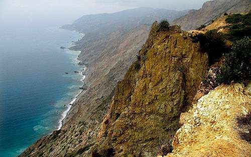
Mount Orizaba is the loftiest point on Santa Catalina Island, some 20 miles distant from the coast of Southern California. Rising straight from the pounding surf to anchor the eastern half of the island, its earthen ramparts tower over the cool waters of the Pacific.
Given its proximity to 14 million people, and the ease of ascent, one might expect crowds of casual hikers sporting half-drained bottles of Dasani and sweat-stained fanny packs. However, excluding the resident FAA summit beacon and occasional weekend crowds, Orizaba is remarkably isolated. Most island tourists keep to the bay of Avalon and its civilized pleasures.
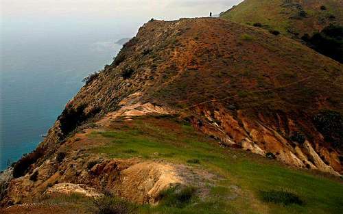
Although still bare of trees on its higher slopes, Mount Orizaba is recovering from the deforestation and subsequent erosion that resulted from years of exploitation by man and beast. Pigs and cattle once consumed every bit of flora and man stripped the land of wood and mineral. Today Orizaba is wholly owned by the Catalina Island Conservancy, which is dedicated to preserving the health and vitality of Catalina's unique environment in perpetuity for the benefit of future generations.
From the summit one can experience sweeping panoramic vistas of emerald ocean, azure skies and rugged earth. San Clemente Island, Palos Verdes, the San Gabriel Mountains, the Santa Monica Mountains and Santiago Peak are all visible from the summit on a clear day.
Quick Facts
There are numerous heights published for this peak, ranging from 2069' to 2130'. This page recognizes the height set by the Catalina Island Conservancy. Mount Orizaba is #141 on the list of California Peaks With Over 2,000' of Prominence, #41 on the list of United States Island Highpoints and #13 among California Peaks With 25 Miles of Isolation.
Getting There
You can reach the villages of Avalon and Two Harbors by ferry from San Pedro/Port of Los Angeles, Dana Point or Long Beach harbors. Both Catalina Express and Catalina Cruises conduct multiple runs to the island every day.
For those with finer or more expensive tastes, airplane flights from Los Angeles and Orange County take about 15 minutes. Expect a 30 minute flight from San Diego. Unless noted otherwise, all regular and chartered flights service the island's mountaintop Airport-in-the-Sky. Flights are limited to daytime hours.
Allied Air Charter (213) 510-1163
Daily from Santa Monica Municipal: $80, Long Beach Municipal: $60, and Orange County's John Wayne Memorial Airport: $70.
Charter flights from Los Angles International: $225 for up to six people, and San Diego's Montgomery and Lindbergh fields: $350 for up to six people.
Catalina Flying Boats (213) 595-5080 or 510-2530
Seaplanes depart Martin Aviation from Long Beach Airport for Avalon's Pebbly Beach terminal. Call for a schedule. Cost: $75.
Catalina Vegas Airlines (619) 292-7311
Flights leave San Diego's Montgomery Field about 10 A.M., 1:30, and 3:30 to return about 11:15 A.M., 2:45, and 4:45 respectively. Cost: $110. Additional departures are available at higher cost.
Holiday Airways (714) 261-6616
You can book charters from Orange County any time. Cost: $98 with a six-person minimum.
Eagle Aviation (213) 426-2118
You can book charter flights from Long Beach any time. Cost: $250 for the plane with a three-person maximum.
Helicopter flights between Long Beach or San Pedro and Pebbly Beach terminal take 15 to 18 minutes. Each craft carries up to six passengers. Most flights require a full passenger load.
Island Express, (800) 228-2566
Flights leave daily from San Pedro and from the heliport adjacent to the Queen Mary in Long Beach on the hour, 8 A.M. to 7 P.M. and return on the half-hour. Cost: $106.
Helitrans, (213) 548-1314 or (800) 262-1472
Flights leave San Pedro's Catalina Terminal every day on the hour between dawn and dusk and return on the half-hour. Cost: $108.
Hiking Directions
Once off the boat, you have the choice to trek into the island's dusty interior, or to pick up bus tickets at Pavilion Lodge, about a block from the Avalon ferry landing. (Go right on Crescent Avenue; the lodge is at the corner of the first street on the left, Claressa Avenue.) To get to the bus stop, keep going north on Crescent Avenue and then head left on Catalina Avenue to Island Plaza. The bus ride takes about 20 minutes and drops you off at the Mount Orizaba/Black Jack Junction trailhead. From here on, you’re likely to see more buffalo than people.
The first mile is a moderate to steep 350-foot climb on a fire road. From Black Jack Junction, hike 1.3 miles. continuing past the turnoffs for Black Jack Campground and Cottonwood–Black Jack Trail. One you pass these turnoffs, you will find a trail that heads left. Take this trail and continue 1.1 miles to Mount Orizaba. Black Jack Mountain stands to the south, crowned with a radio tower. A lot of people summit Black Jack on their way to the island highpoint. At 2,006 feet, it’s only slightly lower than Orizaba.
Alternative Route
You can also hike southeast from Two Harbors. Begin by heading southeast on Banning House Road past the big rust colored water tank - unless it gets painted - and follow the road until it reaches a major fork (here the main road turns right). Turn left up to Big Springs Reservoir, which is perched atop a 900' cliff above the northern coast of the island. Here, you will head several miles along the road as it skirts the coast until reaching Airport-In-the-Sky. Follow the road SSE past the airstrip until you reach your first right. Turn here! It's 1.1 miles to the summit.
If you flew into Airpot-in-the-Sky, simply follow the above directions as if you were coming from Two Harbors.
Red Tape
Permits:
You'll have to get a hiking permit from the Catalina Island Conservancy. These are free of charge and available the day of your hike. You should also pick up an island trail map. These are published by the Conservancy and details all roads, hiking trails and campsites on Santa Catalina. Permits and trail maps can be obtained at the following locations:
Conservancy House in Avalon, at 125 Claressa Ave.
Open from 8:30 AM to 3:30 PM, 7 days a week, may close for lunch.
Call 310-510-2595
Catalina's Airport-in-the-Sky
Open daily from 8 AM to 5:00 PM (winter) 7:00 PM (summer)
Call 310-510-0143.
Two Harbors Visitor Information Center
Open daily from 9:30 AM to 4:00 PM (winter) 6:30 PM (summer)
Call 800-422-8475.
OR
Rather than pick up the hiking permit at the sites listed, you can just print one at home. It can be obtained in advance from the Conservancy's website at www.catalinaconservancy.org
Trekking Rules and Regulations:
Please note that hiking permits are issued for day hikes only and not for overnight camping or backpacking.
The following are some rules and regs provided by the Catalina Island Conservancy:
Please use trash containers where provided. When none are available, please carry refuse out with you. Section No. 374B of the California Penal Code covers the anti-littering act and its enforcement.
Tree cutting or gathering of wood, plant collecting, or in any way removing or defacing any natural or man made feature, including archaeological sites, is prohibited.
Do not disturb wildlife. All plants and animals are protected. Many are found only in Catalina and are rare and/or endangered species.
No hiker shall carry firearms, traps or other hunting equipment while in the interior of Catalina.
Hitchhiking is prohibited.
Carry a signed permit while hiking.
Dogs must be held on a leash while in the interior of Catalina.
Adhere to all regulations that govern your travel in the back country. As a visitor you have the responsibility to leave the natural environment free of any permanent imprints.
Stay on roads and trails.
![Parson s Landing]()
Nestled beneath the eves of Black Jack Mountain and Orizaba lies the high and dry Blackjack Campground. This primitive facility provides eleven campsites spread among pine and eucalyptus trees some 1,600 feet above sea level. Each site offers sweeping views of rolling terrain and ocean. Situated miles from both Avalon and Two Harbors, Black Jack Campground offers solace and adventure in Catalina’s rugged interior.
Picnic Tables
BBQ and fire ring
Showers
Fresh water
Chemical toilets
Lockers
The Black Jack Campground trailhead is accessible by foot, Airport Shuttle from Avalon, or by Safari Bus. The trailhead for the campground is nine miles from Avalon and 11.8 miles from Two Harbors. Once at the trailhead, it's a 1.5-mile walk in to the campsites.
23 campsites, including eight group areas
Picnic tables
BBQ and fire ring
Showers
Fresh water
Chemical toilets
Lockers
Kayak and snorkel gear is available from Wet Spot Rentals daily through July and August or by advance reservation
Calling 310-510-2229.
The Hermit Gulch Campground is Avalon’s sole camping facility. Located 1.5 miles from the boat landing, this campground is situated on a tree-lined field in Avalon Canyon close to the Wrigley Memorial and Botanical Garden. Hermit Gulch offers vistas of the surrounding hills and access to the myriads of hiking trails nearby.
Picnic tables
BBQ
Showers
Fresh water
Flush toilets
Vending machines
Rangers sell charcoal, ice, fire logs and propane
Hermit Gulch is located on Avalon Canyon Road 1 mile from downtown Avalon. Taxi service is available from the Avalon Boat Landing.
(a) the minor is accompanied by his or her parent or parents, legal guardian or other adult person having the lawful care or custody of the minor, or by his or her spouse eighteen years of age or older;
(b) the minor is upon an errand directed by his or her parent or parents or legal guardian or other adult person having the legal care or custody of the minor, or by his or her spouse eighteen years of age or older;
(c) the minor is attending or going to or returning directly home from a public meeting, or a place of public environment, such as a movie, play, sporting event, dance or school activity; or
(d) the presence of such minor in said place or places is connected with or required with respect to a business, trade, procession or occupation in which said minor is lawfully; or
(e) the minor is involved in an emergency such as a fire, natural disaster, automobile accident, a situation requiring immediate action to prevent serious bodily injury or loss of life, or any unforeseen combination of circumstances or the resulting state which calls for immediate action.
You can swim at your own risk since there are no lifeguards on duty at beach camping facilities.
There are no electrical hook-ups available at any campsites.
In accordance with the L.A. County Fire Code, fires and smoking are permitted in the BBQ and fire ring areas only. No wood fires of any kind are allowed at the Hermit Gulch Campground.
Gathering wood or plants, or in any way defacing or removing any natural or artificial feature of the island is prohibited.
Firearms, archery equipment, traps or other hunting equipment are also prohibited if you're a visitor. Many of the island's residents are ex-firefighters or policemen and often designate certain remote areas as shooting ranges.
All plants and animals on the island are protected. Buffalo and other wildlife are unpredictable, so keep your distance when possible.
Campgrounds and public beaches have quiet hours between 10:00 PM and 8:00 AM . Radios or amplified sound/music aren't allowed at any time.
The island is somewhat like a ship lost at sea. It drifts north at a rapid pace of several centimeters per year. In time, the island is expected to disappear in the stormy seas of the north Pacific. A likely target: the Aleutian trench.
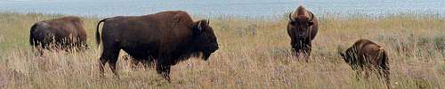
The island is also know for its plethera of wild bison, which congregate about the slopes of Orizaba and Black Jack. It is likely they were first imported in 1924 for the silent film version of Zane Grey's Western epic, "The Vanishing American." Since then, the bison population grown to as many as 600. Bison were frequently removed and sent to the mainland for auction. Recently, another solution was implemented. The Catalina Island Conservancy initiated a scientific study that determined a herd of between 150 and 200 would be good for the bison and ecologically sound for the island. In 2004, the Conservancy joined with several Indian tribes, including the Morongo Band of Mission Indians, the Tongva (thought to be Catalina's original inhabitants some 4,000 years ago), and the Lakota tribe of South Dakota. Some 100 bison were relocated 'home' to the Great Plains. The Conservancy plans to pursue a similar plan when the bison population exceeds 200. Although these great beasts are not native to the island, they cmake up an important part of Catalina's cultural fabric. As such, the Conservancy has no plans to remove all Bison from the island.
![Bison Sun]()
![Furry Nomads]()
Official site of the Catalina Island Conservancy
![Land s End]()
![East End]()
![The Armada]()
![Land s End 2]()
![Silver and Gold]()
![Dark Angels]()
![Island Interior]()
![Coastline]()
![Francis Scott Water Ski]()
![Boy Scout Camp]()
![Lonely Outpost]()
![Tiny Boats]()
![The Jet Set Mingle]()
![Sir Francis Drake]()
![Catalina Backcountry]()
![Starlight Cove]()
![Props to Propst]()
![Rampart]()
![Untitled]()
The following are some rules and regs provided by the Catalina Island Conservancy:
Please use trash containers where provided. When none are available, please carry refuse out with you. Section No. 374B of the California Penal Code covers the anti-littering act and its enforcement.
Tree cutting or gathering of wood, plant collecting, or in any way removing or defacing any natural or man made feature, including archaeological sites, is prohibited.
Do not disturb wildlife. All plants and animals are protected. Many are found only in Catalina and are rare and/or endangered species.
No hiker shall carry firearms, traps or other hunting equipment while in the interior of Catalina.
Hitchhiking is prohibited.
Carry a signed permit while hiking.
Dogs must be held on a leash while in the interior of Catalina.
Adhere to all regulations that govern your travel in the back country. As a visitor you have the responsibility to leave the natural environment free of any permanent imprints.
Stay on roads and trails.
Camping
Black JackNestled beneath the eves of Black Jack Mountain and Orizaba lies the high and dry Blackjack Campground. This primitive facility provides eleven campsites spread among pine and eucalyptus trees some 1,600 feet above sea level. Each site offers sweeping views of rolling terrain and ocean. Situated miles from both Avalon and Two Harbors, Black Jack Campground offers solace and adventure in Catalina’s rugged interior.
Facilities and Activities
Picnic Tables
BBQ and fire ring
Showers
Fresh water
Chemical toilets
Lockers
Directions to Black Jack
The Black Jack Campground trailhead is accessible by foot, Airport Shuttle from Avalon, or by Safari Bus. The trailhead for the campground is nine miles from Avalon and 11.8 miles from Two Harbors. Once at the trailhead, it's a 1.5-mile walk in to the campsites.
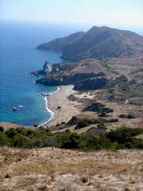
Little Harbor
Located about seven miles east of Two Harbors and 16 miles from Avalon, Little Harbor is a sandy, beachfront campground. This place can get a little crowded, but not much beats a blazing fire and salty sea air.Facilities and Activities
23 campsites, including eight group areas
Picnic tables
BBQ and fire ring
Showers
Fresh water
Chemical toilets
Lockers
Kayak and snorkel gear is available from Wet Spot Rentals daily through July and August or by advance reservation
Calling 310-510-2229.
Directions to Little Harbor
Little Harbor is accessible from Two Harbors or Avalon by Safari Bus or foot along one of the islands unpaved roads. Check the island trail map you obtained along with your hiking permit for specifics.The Hermit Gulch Campground is Avalon’s sole camping facility. Located 1.5 miles from the boat landing, this campground is situated on a tree-lined field in Avalon Canyon close to the Wrigley Memorial and Botanical Garden. Hermit Gulch offers vistas of the surrounding hills and access to the myriads of hiking trails nearby.
Facilities
Picnic tables
BBQ
Showers
Fresh water
Flush toilets
Vending machines
Rangers sell charcoal, ice, fire logs and propane
Directions to Hermit Gulch
Hermit Gulch is located on Avalon Canyon Road 1 mile from downtown Avalon. Taxi service is available from the Avalon Boat Landing.
Fees
$12 for adults; $6 for children, per person per day.Tips
You should check-in at either Island Plaza in Avalon or Two Harbors Visitor Services. If you pre-purchased firewood, you will be issued a lockbox key when checking in. There is a 10-day maximum stay at all campgrounds.Permit Required
Camping permits are required year-round and issued upon check-in at Two Harbors Visitor Services, Hermit Gulch Campground, or Island Plaza.Alcoholic Beverages
Under-age drinking is illegal at Santa Catalina's campground facilities (BPC 25662). Expect this law to be strictly enforced.Curfew For Minors
It is unlawful for any minor under the age of eighteen years to be present in or upon any public street, avenue, highway, road, curb area, alley, park, playground, or other public ground, public place, or public building, place of amusement or eating place, vacant lot or unsupervised place between the hours of 10:00 p.m. on any day and sunrise of the immediately following day; provided, however, that the provisions of this section shall not apply:(a) the minor is accompanied by his or her parent or parents, legal guardian or other adult person having the lawful care or custody of the minor, or by his or her spouse eighteen years of age or older;
(b) the minor is upon an errand directed by his or her parent or parents or legal guardian or other adult person having the legal care or custody of the minor, or by his or her spouse eighteen years of age or older;
(c) the minor is attending or going to or returning directly home from a public meeting, or a place of public environment, such as a movie, play, sporting event, dance or school activity; or
(d) the presence of such minor in said place or places is connected with or required with respect to a business, trade, procession or occupation in which said minor is lawfully; or
(e) the minor is involved in an emergency such as a fire, natural disaster, automobile accident, a situation requiring immediate action to prevent serious bodily injury or loss of life, or any unforeseen combination of circumstances or the resulting state which calls for immediate action.
Swimming
You can swim at your own risk since there are no lifeguards on duty at beach camping facilities.
Hook-Ups
There are no electrical hook-ups available at any campsites.
Fire Precautions
In accordance with the L.A. County Fire Code, fires and smoking are permitted in the BBQ and fire ring areas only. No wood fires of any kind are allowed at the Hermit Gulch Campground.
Gathering Wood
Gathering wood or plants, or in any way defacing or removing any natural or artificial feature of the island is prohibited.
Hunting
Firearms, archery equipment, traps or other hunting equipment are also prohibited if you're a visitor. Many of the island's residents are ex-firefighters or policemen and often designate certain remote areas as shooting ranges.
Plant and Animal Life
All plants and animals on the island are protected. Buffalo and other wildlife are unpredictable, so keep your distance when possible.
Quiet Hours
Campgrounds and public beaches have quiet hours between 10:00 PM and 8:00 AM . Radios or amplified sound/music aren't allowed at any time.
Geology and Bison
According to Sunset magazine, "Catalina ... is a geographic anomaly. Unlike California's other seven Channel Islands, it didn't break away from the mainland, but was formed by the upward heave of tectonic plates. The island is very rich in quartz and silver, to the point that some beaches on the seaward side have silvery-grey sand."The island is somewhat like a ship lost at sea. It drifts north at a rapid pace of several centimeters per year. In time, the island is expected to disappear in the stormy seas of the north Pacific. A likely target: the Aleutian trench.
The island is also know for its plethera of wild bison, which congregate about the slopes of Orizaba and Black Jack. It is likely they were first imported in 1924 for the silent film version of Zane Grey's Western epic, "The Vanishing American." Since then, the bison population grown to as many as 600. Bison were frequently removed and sent to the mainland for auction. Recently, another solution was implemented. The Catalina Island Conservancy initiated a scientific study that determined a herd of between 150 and 200 would be good for the bison and ecologically sound for the island. In 2004, the Conservancy joined with several Indian tribes, including the Morongo Band of Mission Indians, the Tongva (thought to be Catalina's original inhabitants some 4,000 years ago), and the Lakota tribe of South Dakota. Some 100 bison were relocated 'home' to the Great Plains. The Conservancy plans to pursue a similar plan when the bison population exceeds 200. Although these great beasts are not native to the island, they cmake up an important part of Catalina's cultural fabric. As such, the Conservancy has no plans to remove all Bison from the island.

Weather & External Links
Avalon Weather Forecast.Official site of the Catalina Island Conservancy


Bob Burd - Nov 29, 2011 8:31 pm - Voted 10/10
island geologyAccording to Sunset magazine, "Catalina ... is a geographic anomaly. Unlike California's other seven Channel Islands, it didn't break away from the mainland, but was formed by the upward heave of tectonic plates." According to the NPS brochure, none of the eight islands were ever connected to the mainland. Also, there is a gated fence along the road between Black Jack and Orizaba at approximately the halfway point. Beyond this, one is trespassing (but unlikely to be cited since it's pretty remote). Helpful page, btw, thanks!
Eleutheros - Dec 17, 2011 1:58 pm - Hasn't voted
Re: island geologyThanks for this Bob!
mtbaxter - Sep 14, 2013 4:22 pm - Hasn't voted
Hiking permits and possible trespassingRather than pick up the hiking permit at the sites listed, I suggest you just print one at home. It can be obtained in advance from the Conservancy's website at www.catalinaconservancy.org In regard to Bob Burd's note, there are actually two fence/gates you must cross. On neither, however, is there any sign regarding trespassing. The first gate just past the campground has a worn sign that only requests the gate be shut as it is used to isolate species for conservation. (The gate is locked, so this is a non-issue for the hiker). The second gate at the summit only has a sign stating it is illegal to have a gun within, on the federal property. It FEELS like it should be illegal, but it is not posted as such, and the 3 foot high fence is very easily surmounted. Photos submitted
gimpilator - Mar 11, 2015 9:48 am - Hasn't voted
New Bike FeeYesterday I was charged $70 by the conservancy company for "bike permits" for the two of us. From what we can tell, this is not a true conservancy but rather a profitable business. There are no visible land or habitat restoration efforts, however there is plenty of evidence that they are raising a fortune in the tourist industry.
Eleutheros - Mar 17, 2015 9:16 pm - Hasn't voted
Re: New Bike FeeThank you for mentioning this. Yes, they are definitely a business... sad to hear this.
Jens Midthun - Sep 2, 2015 4:53 pm - Hasn't voted
Keep Right at Water TowerAfter the turnoff for Black Jack Campground, there is another fork in the road near a rusty old Water Tower. You must go right at this fork to get to Orizaba.
Eleutheros - Jan 1, 2016 1:13 am - Hasn't voted
Re: Keep Right at Water TowerThank you, Jens. This is mentioned in the 'alternative route' section on the main page.
Eleutheros - Jan 1, 2016 1:13 am - Hasn't voted
Re: Keep Right at Water TowerThank you, Jens. This is mentioned in the 'alternative route' section on the main page.