
|
|
Mountain/Rock |
|---|---|
|
|
46.94140°N / 115.5929°W |
|
|
Hiking, Scrambling |
|
|
Summer, Fall |
|
|
6879 ft / 2097 m |
|
|
Overview
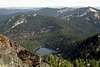
 Crag Peak rising above Heart Lake
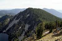 Heart Peak
 Crag Lake
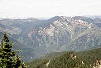 Crag/Heart from Black Mt.
 North side of Heart Peak
Crag Peak and Heart Peak form the central part of the main ridge of the popular group of mountains known as the Mallard Larkins Pioneer Area. The main axis of this group forms the divide between the North Fork Clearwater River and the Little North Fork Clearwater basins and is also the boundary between the Clearwater National Forest on the south and the Idaho Panhandle National Forest on the north. Though these mountains are not terribly high in elevation, they have dramatic vertical lift from the deep canyons of the Clearwater Basin. Most of the steep south slopes rise more than a mile above the North Fork Clearwater River before abruptly falling off to the sheer glacially carved north facing cirques.
The two peaks are grouped here because they are equal approximately summit points on the same mountain mass, being separated by the small saddle of Heart Pass. Maps list Crag Peak as slightly higher at 6,879 feet, while Heart Peak is 6,870. It is interesting that looking back on the other from each summit gives the impression that Heart Peak seems slightly higher as does observing them from Goat Ridge to the west, even though Heart Peak is slightly further away from that vantage point. However, the peaks are virtually equals and the given elevations kept until someone proves otherwise.
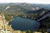
Crag Peak is formed of near vertical rocks and broken cliffs on the northeast and northwest aspects, both of which fall into cirque lakes. The south side is steep, but mostly covered with a forest of mountain hemlock and subalpine fir over beargrass and whortleberry. The western extension of the summit is formed of large jumbled boulders with juniper and some tangled small trees. A few struggling whitebark pines are found on its summit, which is a bit low for the species in this area. Heart Peak is much more heavily forested with its south slope being much like Crag Peak, but the summit is more pointed and formed of giant boulders. The steep easterly and northerly slopes are also formed of steep broken rocks and cliffs, but with much more tangled vegetation. Scrambling up these slopes is possible, but would be very difficult. Between the two peaks and 560 feet below sits Heart Lake, which is one of the largest and deepest subalpine lakes in the northern portion of Idaho.
The area has a pronounced orographic effect which results in extremely deep snows at the higher elevations and heavy rains in the canyons. As a result of this snow, portions of the trail are impassable well into July. Also the lower elevations are well known to support several plant species with ranges disjunct from the Pacific Coast. There are a few high elevation plants that also illustrate this phenomenon.
The vicinity is very popular and in the summer receives relatively heavy use for this area. In the fall hunters will take over the parking areas and be found throughout the slopes. Don’t ever expect isolation and in the fall be sure to wear bright orange and if possible travel in groups. The area is also well known for mountain goats, which can frequently be seen on the rugged north slopes.
Getting There
 Junction of trails 113/65
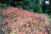 Tr 65 hemlock/huckleberry
 Burn near trailhead
Either from the east or west, follow Highway 12 to the town of Orofino and turn east across the bridge over the Clearwater River into downtown. Keep on this road for 26.5 miles to where it forms a T at the Bald Mountain Ski Area turn off. Take a left on the main road (Highway 11) and continue 7.3 miles to the next T at the small town of Headquarters. Headquarters is a small group of buildings that is an administrative center for the Potlatch Corporation; there are no services. Turn left at Headquarters (forest road 247) and continue for 24 miles to the bridge of the North Fork Clearwater River. Immediately turn left off the pavement onto road 700. After about a mile this road leaves the river and turns north up the Isabella drainage. After about two more miles the road turns to the left, leaving Isabella Creek. Continue up the 700 road, climbing for ten more miles to the trailhead where the road crosses Smith Ridge.
From the trailhead, trail 240 heads east for about two miles then turns north with the main ridge for about four more miles to Larkins Peak. The trail cuts across the east side of this peak and continues east for about two miles to Heart Pass. The easiest way to each summit is straight up the respective ridge line from this pass. The 240 trail is indicated on maps to follow the ridgeline more or less the entire way. It has been rerouted in recent years to a more continuous and gentle grade mostly on the north side of the ridge for the first two miles and the west side in the vicinity the Goat Ridge high point. The trail is well maintained and the trailhead obvious so there is no need to be concerned with differences between the map and the ground.
These peaks can also be reached by trails 95 and 96 that are accessed from near the end of the Isabella Creek road, 705. These longer routes climb from much lower elevations and require much more time and effort. Trail 96 has not been maintained in years and may not exist in the upper elevations. This general warning can apply to many sections of trails in the more distant Mallard Larkins locales.
Red Tape
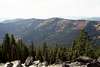
NoneViews From The Summits


Camping
 Heart Lake
People wanting to car camp and have a long day hike can use the very scenic Aquarius Campground, which is immediately upriver from the bridge crossing the North Fork Clearwater River. This campground is situated in old growth western red cedar against the rapids of the North Fork. There are only a few campsites so arrive early, especially if visiting the area on a weekend. There are some nice dispersed camping areas several miles up the river, some with nice sandy beaches. These are often full as well. To the south of the river there are many dispersed campsites off the paved road along Beaver Creek that would provide good car camping. But most of these are filled up with loggers who work on the Potlatch timber lands in the area. Backpackers will find several remote camping possibilities at the numerous lakes in the Mallard Larkins Pioneer Area. Heart Lake is the closest to these peaks being found at the north foot of the saddle between the two mountains.
When To Climb
The upper elevations get a lot of snow and hiking to the summit before mid-July may be difficult some years. Most precipitation on the lower elevations is in the form of rain, thus the interesting montane rainforests on the lower slopes can easily be explored in winter. Of course this is depending on road conditions into the North Fork, which are not always open over Beaver Pass.Mountain Conditions and Information
 Crag Peak
Go to the mountain prepared for variable conditions. With over a mile of vertical lift, mountain temperatures can vary dramatically.
Contact the North Fork Ranger District of the Clearwater National Forest for information and current conditions.
North Fork Ranger District
12730B Highway 12
Orofino, ID 83544
(208) 476-4541
Canyon Work Center (summer only)
(208) 476-8306
NOAA Forecast