
|
|
Mountain/Rock |
|---|---|
|
|
44.02127°N / 118.18283°W |
|
|
Malheur |
|
|
Mixed |
|
|
Summer, Fall |
|
|
6837 ft / 2084 m |
|
|
Castle Rock Overview
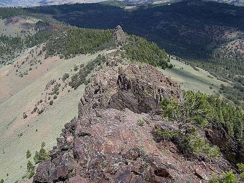
In the remote southern reaches of the Malheur National Forest and the Blue Mountains rises a towering pinnacle visible from any highpoint within 60 miles, including views of it from where I-82 crosses the Snake River on the Idaho-Oregon Border. Although not a major rock climbing challenge, reaching the summit of Castle Rock requires climbing up several broken vertical faces to reach its summit over 100 feet above the forest below on the east side (much higher on the west side). The easiest path to the summit requires less than 60 feet of vertical rock climbing and hundreds of feet of careful lateral travel along the mountains exposed western face. Bringing rope to rappel off the summit is certainly a consideration, although not necessary for the deliberate/careful downclimber. Take your time finding a route to the summit, there are many places the summit block could be climbed, some much easier than others.
Castle Rock is 50 miles SE of John Day, 55 miles NE of Burns, or 115 miles west of Ontario, an area A.K.A. the middle of nowhere. There are no other real attractive mountains in the immediate area, the only other viable hiking would be Ironside Mountain or the Bullrun Rock Wilderness 16-20 miles to the north, although poor connecting roads would make this an ambitious goal for a single day. Typical of the Malheur National Forest, Castle Rock is home to deer, elk, antelope, bear, and cougars. The mountain itself has a base of juniper and sagebrush, and is topped with spruce, fir, pine and mahogany. This is an incredibly diverse area, enjoy the view which spans from the distant Wallowa Mountains in the north to the Steens Fault Block in southeast Oregon. Castle Rock is number 151 on the Oregon Prominence List with 1537 feet of prominence.
 the summit
Getting There
From Burns, Oregon travel 58 miles east on Oregon state Highway 20 to Juntura. From Vale, Oregon near Ontario travel 56 miles west on Highway 20 to the west side of Juntura. Once on the west side of Juntura turn north on Hilda Road which turns into Beulah Road, a two lane gravel road that travels 14 miles up the North Fork of the Malheur River to Beulah Reservoir. Driving up the river you will catch frequent views of Castle Rock on the horizon ahead. Remain on the gravel road and follow it to and around Beulah Reservoir on its east shore to the north side of the lake where the road will split. Turn left and travel half a mile to a single lane dirt road which splits off to the north towards Castle Rock. This is Castle Rock Road. Essentially you will remain on this road until you find a nice spot to pull over and begin your hike. Once you turn onto Castle Rock Road, expect 5-10 miles of travel. This road is lightly maintained and crosses a small stream, driving a high clearance vehicle is most likely necessary at all times.Camping / Red Tape
No camping restrictions exist. On the south side of Castle Rock near its base is a hunters camp. There are several wide spots and turn outs in the road along the east side of Castle Rock that could be used for camping. This is a remote and isolated area, do not expect to see many people once you travel up Castle Rock Road away from Beulah Reservoir. The reservoir roughly 8 miles south of Castle Rock has outhouses and camping available along the shoreline. Chukar Park between Beulah Reservoir and Juntura has 18 campsites, vaulted toilets, and running water. This is a cool and green campground alongside the typically roaring Malheur River. Easily the nicest outdoor camping accomodations in the area, however be prepared for mosquito's.Burning restrictions are in effect throughout most of the summer. Vehicles traveling in the wilderness are required to carry a bucket, shovel and axe.

The Route
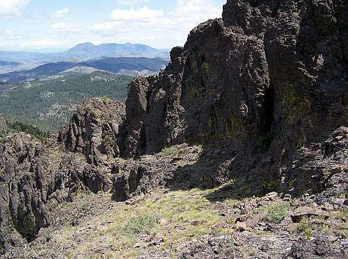
This is a direct route to the summit that runs about 2 miles roundtrip with 1500 feet of elevation gain. To begin; park along Castle Rock road directly east of the summit. Hike up the mountain aiming towards the right side of the rocky summit, a narrow ridgeline that takes off towards the north and a shorter pinnacle. Once you have gained the ridge north of Castle Rock and are looking at the north side of the summit monolith, a chute can be found on the northeast face by basically walking directly south to the rock. Here you will climb up the chute through a steep boulder field to a 20-30 foot rock wall. Once you gain the top of the wall you will see a ledge that varies between 2 and 5 feet in width and circumnavigates the block on the west face. Carefully walk this ledge around to the midpoint of the summit block where several class 4 routes can be found up the face to the summit above. Be safe; Its a long fall off the west face!Below, the ledge along the west face, including a narrow section and the first cliff in the smaller pictures


Weather

