
-
 16515 Hits
-
 91.14% Score
-
 34 Votes
|
|
Mountain/Rock |
|---|---|
|
|
43.87690°N / 109.3331°W |
|
|
Hiking, Mountaineering |
|
|
Summer |
|
|
12449 ft / 3794 m |
|
|
Overview and Climbing Information

If you are lucky enough to be standing atop Mount Crosby, you are not only on a mountain that is among the Absarokas’ highest (in fact, it is the range's 10th highest) and which is higher than most state highpoints but also on a mountain that sees few human visitors and commands an extensive view of what is likely the wildest country in the Lower 48: Wyoming’s Washakie Wilderness. This is country where not very many human feet tread even though many of the summits are in view of the famous and vastly more popular Teton and Wind River Ranges. This is country where wolves and grizzlies roam, where flower-bejeweled tundra basins and plateaus spread for what seems like forever. This is country where multi-day approaches to mountains are common and where the mountains seem to come in two varieties—broad and rolling with relatively gentle ridges or pinnacle-armed and inhospitable to climbers due to some of the rottenest rock to be found anywhere. Fortunately, Mount Crosby is an easy, albeit steep, walk-up and is attainable for day hikers.
“Climbing” Mount Crosby is an undertaking requiring about 4 miles (one-way) and 3300’ of elevation gain. A Class 1 trail guides one for about 3 of those miles and 2300 of those feet, but it is in places so steep and in others so faint that it often feels more like Class 2. The rest of the way is Class 2, much of it on talus. The short of it is that you hike to 11,480’ Greybull Pass and then hike west and southwest along the ridgelines to reach Mount Crosby.
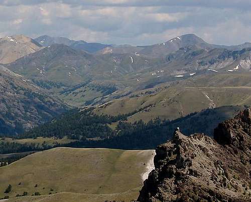 Crosby from the southwest-- by jimmyjay
From the east end of the Kirwin parking area at 9200’, a trail starts heading north and uphill. This is the Brown Basin Trail. There was a sign indicating it as recently as July 2007, but if there is no sign, look around for the trail. There is only one leaving the parking area.
For about a mile, the trail climbs switchbacks through sagebrush and trees, and good views are almost always present. When the switchbacks end and the trail starts heading straight up to timberline, the trail becomes faint in places and sometimes disappears entirely. Look for cairns, some of which may have wooden posts jutting from them.
As you enter Brown Basin, take care to stick to the trail, as you are walking amidst delicate tundra. Even though the basin has steep mountain walls flanking it on all sides but the one you have hiked up, it feels vast and very open. At about 11,000’, the trail crosses to the right of what is left of the stream draining the area. Just past here, you may see a faint trail going straight while the main trail bends right. Do not take this faint trail. First, a small rock pile blocks it, indicating it is closed off (an attempt to heal a scar on the landscape). Second, it peters out very quickly, which is obvious from above.
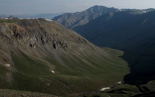
 Brown Basin
The main trail follows long switchbacks that almost feel easy because of their length and gentle grade, but make no mistake—they get you up. Close to the pass, you will reach a trail junction. The left fork seems to head toward Crosby’s ridges and cut off some distance, but it does not. In fact, it actually follows a pair of long switchbacks to reach the right fork just a few feet below the pass. The right fork climbs steeply on loose dirt to the pass. So take your pick.
Greybull Pass is a spectacular destination all on its own, with views deep into the wildest parts of the Washakie Wilderness. There are also several pinnacles and gendarmes flanking the north side of the pass; what looked so gentle from Brown Basin has an entirely different character on its other side.
 Greybull Pass
From the pass, what looks like a climber’s trail or a goat trail climbs up Crosby’s ridges. Up close, this trail seems to disappear, but it is impossible not to find the way. Crosby has a false summit; the rounded summit that appears after the first steep climbing stretch is not the actual summit, which is about 400’ higher than this false summit. You can avoid the false summit by following either of two game trails that contour along its northern side. Soon, the true summit comes into view, and though it seems to feature a rugged final approach, it does not. There is a cairn at the summit, but no register.
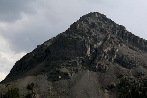
 Mount Crosby
Up top, soak in the wildness all around you and then get out your map and play Name That Peak. Prominent Absaroka summits visible include Brown Mountain, Mount Sniffel, Spar Mountain, Cascade Peak, the Washakie Needles, Dunrud Peak, Dollar Mountain, Mount Burwell, Pyramid Peak, the Warhouse formation, Yellow Ridge, and Francs Peak, the range’s highest. Enjoy.
 Francs Peak, highest of the Absarokas
Getting There

You will have to drive to the Kirwin trailhead. 4WD is recommended, but high clearance and AWD will suffice under most warm-weather conditions. Kirwin was a mining boomtown many years ago, and several structures still remain in the area. The ruined townsite is a popular destination for locals who like to drive up for lunch and a tour, but few people outside the area know anything about Kirwin and the awesome trail system it accesses. Kirwin is also one of the most beautiful trailheads in the Rockies, with towering, brooding mountains all around it.
From Meeteetse, 32 miles south of Cody, turn west onto the signed road for Wyoming 290. In 6.4 miles, turn left onto Wood River Road. At 11.6 miles, the pavement ends. The national forest boundary is at 21.7 miles. Pass Wood River Campground at 22.4 miles and Brown Mountain Campground at 24.8 miles. The road now gets a little rougher, but it is not real 4WD stuff. At 26.8 miles is the first of four stream crossings. This one is short and usually shallow. The second river crossing is at 27 miles. This one is wider and deeper. The third crossing, which is actually two crossings in quick succession, is at 29.3 miles. These are broad but shallow. The last two miles to the trailhead are rocky but not anything to get nervous about. There is one more stream crossing just before the trailhead, but it is a tributary stream and may even be dry. The trailhead is at 33.1 miles. It took me 75 minutes to make the drive.
NOTE: At times, the stream crossings could be difficult or dangerous, so get out and test them before you plow through. I have made it through in a Subaru Outback, but the crossings on the way out were a little sketchy for that car, as the stream was swollen with the previous night’s rain.
Red Tape
This is prime grizzly country, which means special rules about food storage and personal behavior are in order. I will not list them all here. Bottom line: If you don’t know, don’t go.Road construction may affect access. It would be wise to check with the local ranger district about any access restrictions before heading in. Call 307-868-2379 (Meeteetse Ranger District).
 This is grizzly country.
Camping
Camping is available at the Wood River and Brown Mountain Campgrounds (see Getting There about directions). The sites go on a first-come, first-served basis, and there is a $10 camping fee. Water and pit toilets are available at both.You could also sleep in your car at or near the trailhead.