
-
 22776 Hits
-
 83.1% Score
-
 16 Votes
|
|
Mountain/Rock |
|---|---|
|
|
38.18610°N / 78.7775°W |
|
|
Trad Climbing, Toprope, Scrambling |
|
|
Spring, Summer, Fall, Winter |
|
|
2600 ft / 792 m |
|
|
Overview
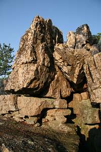
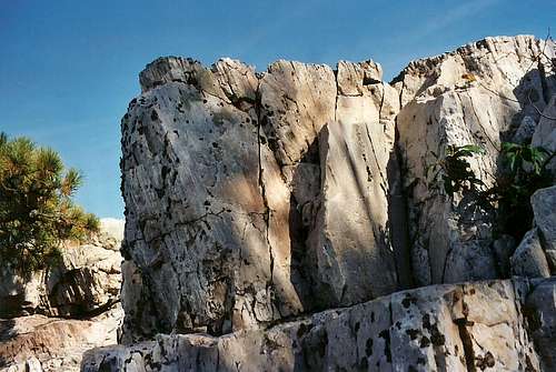
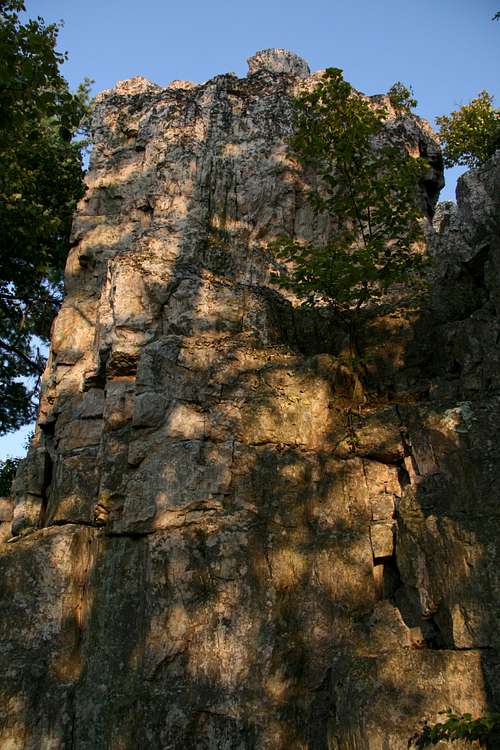
Chimney Rock is just 0.2 miles away from Calvary Rocks on the Riprap Trail in the South District of Shenandoah National Park, and there are great views from it, especially to the north, where talus slopes adorn the south face of Trayfoot Mountain. Thousands of hikers pass by Chimney Rock and perch atop it each year as they complete the scenic 10-mile Riprap-Wildcat Ridge loop. Judging from the lack of litter at the base of the cliffs, though, I’d have to guess that very few people ever bother leaving the white sandstone clifftops to reach their base and, from there, experience any of a number of scrambles or technical climbs back up.
Running north-south between two large outcrops, there is a narrow gap defined by sheer walls, and it is just wide enough to make the younger and more reckless among us (and the older still clinging to their teenaged feats) think they could jump across with a running start (I admit my own vanity and refusal to accept my aging were taunting me here), but anyone considering this should notice that a slip or miscalculation will result in anything from broken bones to death. Instead, take the easy way down into and through this gap (going north); this is the simplest way down (Class 2/2+) to the base of the cliffs, and it takes you past sheer, smooth walls that are almost Utah-like in color and texture.
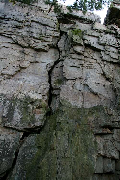
There are three photographs on this page that show some possibilities for roped climbs from the base of the cliffs, and all these routes are at least 5.5 in difficulty—this is based not on my having climbed them but compared to other routes I have climbed. The crack routes seem suitable for leading since the rock is so solid here; the faces are probably better toproped, at least the first time until the climber knows the rock better. Topropers should be aware that they will need gear for setting up anchors; trad climbers, especially those leading, should know that since the clifftop is right off a popular trail, there is the danger of hikers throwing rocks from the cliffs (there are not many loose rocks up top, but I’d be cautious all the same).
If you don’t have a rope and don’t want to go back up the easiest way, you will find several ways to scramble back up, and the difficulty can range from Class 3 to Class 5, depending on your skill and your desire.
The climbs from the base range from 40-50 feet in vertical height.

Reaching Chimney Rock: From the trailhead (see directions in Getting There), hike 0.4 miles along the Appalachian Trail to a signed junction with the Riprap Trail, where you turn left. The concrete post there indicates it is 1 mile to Calvary Rocks. In about 0.75 miles (unfortunately, some of this is downhill), you reach some small cliffs and rock outcrops on your right; these rocks face west and offer fine views, but they are NOT the Calvary Rocks. They do, however, make a nice place to stop, relax, enjoy the scenery, take pictures, and do a little scrambling that shouldn’t be harder then Class 3 unless you try to make it so.
Continue hiking along the Riprap Trail. Shortly past the rocks and cliffs mentioned above, you will start seeing and passing some tall rocks in the woods to your left (east). These are the Calvary Rocks. When you reach a sharp leftward bend in the trail by a prominent clifftop, you have reached the top of Chimney Rock. This spot is 1.2 miles from the Riprap/AT junction, and though there is some up-and-down hiking, there is little overall elevation gain or loss.
 Cliffs...
Getting There
The TH is in the park’s South District at MP 90 and is marked as the Riprap Trail Parking Area (not to be confused with the Riprap Overlook a little farther south). From any entrance station other than the southernmost one (Rockfish Gap), drive south.Red Tape
It costs $15 to enter the park, and that provides access for a week. Annual passes cost $30. The interagency pass, good for yearlong entry to areas managed by NPS, USDA Forest Service, USFWS, BLM, and the Bureau of Reclamation, costs $80.It’s common sense to wear a helmet when climbing, anyway, but it’s especially important here since people at the top might toss rocks over the edge.
The park is open all year, but Skyline Drive does sometimes close after snow or ice storms. The park site does not give current road conditions, so call ahead (540-999-3500).
To reduce poaching, Skyline Drive is subject to closures during hunting season. The information below, copied and pasted from the park site, illustrates the 2006 restrictions—
From November 13, 2006, through January 6, 2007
Skyline Drive
• between Front Royal (Mile 0 at U.S. Highway 340) and Thornton Gap (Mile 31 at U.S. Highway 211), and
• between Swift Run Gap (Mile 65 at U.S. Highway 33) and Rockfish Gap (Mile 105 at U.S. Highway 250),
will be closed daily between 5:00 p.m. and 8:00 a.m.
The central portion of the Drive, between Thornton Gap and Swift Run Gap, will remain open for overnight access to Skyland Resort and Big Meadows Campground until those facilities close on November 26.
Then, beginning November 27, 2006, through January 6, 2007, the entire length of the Skyline Drive will be closed daily from 5:00 p.m. until 8:00 a.m.
Camping
The closest campground is Loft Mountain, which has showers, water, flush toilets, and a store. The access road for the campground is at MP 79.5. The campground is open from mid-May through October, and you can make reservations to stay there, though only 10% of the sites are reservable (see park link for more details). It is the park’s largest campground, but it will usually fill on holiday and October weekends. The fee for a campsite is $15 per night (as of 2007, higher if you reserve).External Links
Official park siteCamping info
Lodging info
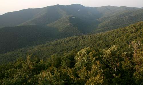 View from the crag