
-
 10313 Hits
-
 81.18% Score
-
 13 Votes
|
|
Mountain/Rock |
|---|---|
|
|
42.62569°N / 0.66300°E |
|
|
Download GPX » View Route on Map |
|
|
Mountaineering |
|
|
Spring, Summer, Fall, Winter |
|
|
10814 ft / 3296 m |
|
|
Overview
 Tempestades & Aneto
The peak Tempestades is the first main summit in East direction from the Aneto (3,404m) the highest point of Pyrenees, but the ridge between both summits are really sharp with stepcrossings of rock-climb only for experts climbers with a great gap in the called Brecha de Tempestades (50m of rappel to descent to the narrow col) and bad cracked rock. For this reason the normal route of Tempestades is completelly different to Aneto and it have interest to enjoy of a great image of the king of the Pyrenees and the spectacular ridge Salenques-Tempestades, classic route of rock-climb. The normal route it’s not difficult with some blocks of I or maximun I+ in some meters in the final near of the summit, but only the mountaineers generally climb this mountain, it’s not for hikers.
The experts in rock-climbing have in the ridge Tempestades-Aneto one of the nicest climbs of the area (AD, III+) but many people as well make the ridge Salenques-Tempestades (D-, V-) the most important ridge of all the Pyrenees.
Secondary summits: Punta de la Brecha Tempestades (3,274m) at west in the ridge to Aneto.
 Aneto & Tempestades
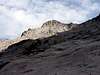


Getting There
Approach to Benasque from Huesca: in the road on direction to Barbastro (N-240). After Barbastro we'll follow the indication to valley of Benasque to the C-1311 to Graus and the C-139 to Benasque across the beautiful gorge of Congosto de Ventanillo.-Puente de Coronas: across the track of Vallibierna in the south of Maladeta Massif. The entry is signaled in the road from Benasque to Hospital de Benasque. After the cross of Cerler we'll arrive to the signal "Vallibierna/Senarta" where's the track of entry to camping area of Senarta. At end of plain in right side is the forest track of Vallibierna.
Red Tape
-Summer (july-august-september): the track of Vallibierna is closed and we'll must to pay the bus.-Spring (may-june)-Autumm (october-november): is possible the approach in car but the track it's not always in good conditions early in the season after the winter. In october-november it's possible the first snowfall and is very dangerous to drive in the track.
-Winter: track closed for risk of avalanches.
The best option is always to search information about the access to Vallibierna in tourism office of village of Benasque.
Camping
-Camping is not allowed in the area generally but you had two good options:-Camping of Senarta (at the beginning of the track of Vallibierna): very economic, with w.c. and green zone to put the tent.
-Refugio de Coronas (at the end of the track): free hut with space for a few of persons in beds and the floor.
It has a few of hotels in the village of Benasque.