
|
|
Mountain/Rock |
|---|---|
|
|
40.21382°N / 111.58831°W |
|
|
Hiking |
|
|
Spring, Summer, Fall, Winter |
|
|
9502 ft / 2896 m |
|
|
Overview
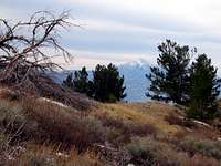 Buckley Mountain offers excellent views of all of the "seven peaks" of Utah county. Here Mt. Nebo is seen from Buckley's south peak.
 Loafer Mountain and Nebo as seen from Buckley's North Peak.
Buckley Mountain is located in Utah, in the southern section of the Wasatch Range in the Spanish Fork Ranger District of the Unita National Forest. As the crow-flies Buckley Mountain is only a mile and a half from the corporate boundary of the city of Provo.
This mountain is the southern most mountain in the group of lower mountains that line the east side of Utah county. Its cohorts, from north to south, include Squaw Mountain, Y-mountain, and Maple Mountain. Its taller neighbor to the east is Corral Mountain. Buckley Mountain is clearly visible from most anywhere in the Provo/Orem valley and raises 5000 ft above the valley. The mountain consists of two peaks separated, as the crow flies, by a little over a half mile; the south peak is 9,153 ft, and the north peak is 9,502 ft.
On its northern side, between it and Maple Mountain, is Slate Canyon. About 2100 ft below the higher peak, on its west side, is a rock outcropping known as Toad Head. Its south side overlooks northern portions of the city of Springville as well as the Kolob Basin.
Evidence of the summer of 2000 fire, that burned much of the trees and vegetation of this mountain, can still be seen as of October 2007.
One of the rewards of climbing this mountain is the unobstructed views it offers of all seven of the "seven peaks" of Utah county. Buckley is often overlooked, and as such another of its attractions is an almost certain guarantee of solitude. Being on the road less traveled, route finding and bushwhacking are required to reach its peaks.
Getting There
Buckley Mountain is located in the backyard of Provo Utah. Provo is 42 miles south of Salt Lake City via I-15.Since there is no defined trail to the top of Buckley Mountain, mountaineers have a few choices of where to get to in order to being ascending. One idea might be to drive to the entrance of Slate Canyon, and from there route find up the north or west side of Buckley. Slate Canyon is located at the south end of Provo just off highway 89.
The shortest route up Buckley is via its east side, which can be reached via the Squaw Peak Trail (closed in winter). Squaw Peak Trail is accessed from Provo Canyon and Hwy 189. From Salt Lake City take I–15 South towards Provo. Continue on I-15 to the 800 North Orem exit. Follow 800 North east through Orem to Hwy 189 in Provo Canyon. Within two miles watch for a sign on the left indicating the Squaw Peak Trail. It begins as a paved road but turns into a rocky, washboarded, dirt, jeep trail soon after it forks and as such a high clearance vehicle is recommended. At the fork take the left path. From its beginning, drive the Squaw Peak Trail 15.8 miles to the Kolob Basin Overlook, and park there. Buckley Mountains north peak is located 1.4 km (8/10 of a mile) W (278°) of the overlook.
Maps of the Squaw Peak Trail often label the Kolob Basin Overlook, as well as Horse Mountain and Buckley Mountain. Horse Mountain isn’t much of a landmark as it doesn’t look anything like a mountain and only raises a few hundred feet above the overlook of Kolob Basin. The little bump 389 m (1276 ft) WxNW (289°) of the overlook is Horse Mountain. In comparison, from the parking spot one can clearly see and recognize the two peaks of Buckley Mountain as well as the saddle between them.
From the parking spot, simply route find to the peaks.
Camping
Buckley Mountain is located in the Unita National Forest and as such one may camp pretty much anywhere. Use common sense and leave a reasonable distance between camp spots and water sources.Routes
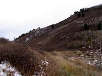 The saddle between the peaks. To ascend, route find up this saddle.
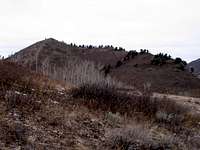 Looking at the North Peak from the South Peak. Simply follow the ridge north then west from South Peak to North Peak.
There are no defined trails that lead to the peaks of Buckley Mountain. Before attempting it, please familiarize yourself with the topographic maps of the area.
The quickest and shortest ascent is via the east facing side of the mountain, up to the saddle (8800 ft) between the peaks and from there to the peak (or peaks) of choice. See “getting there” section to learn how to access the east side.
From the Kolob Basin overlook on the Squaw Peak Trail road, the climb to the saddle is about 350 vertical feet, and between 0.75 and 1.25 miles (depending if you go straight up or if you switch back). From the saddle go due south to the south peak which is a quarter mile away and 350 ft up.
From the south peak to the north peak, descend to the saddle and then ascend the ridge initially going north but turning west about half way along. The approximate walking distance is one mile between peaks (as the crow flies it is only half that distance). You lose 350 vertical feet from the south peak to the saddle and then gain 700 ft from the saddle to the north peak.
Ascending, it shouldn’t take any more than one hour to bushwhack and route find to the south peak from the park spot via the saddle. And from the south peak to the north peak should require only about 45 minutes. Walking along the ridge to the north peak is mostly grass and rocks, whereas the area between the saddle and the south peak is a grassy field (the author noticed bear droppings in this field).
The north peak houses a 3 foot high cairn in which you might find a plastic bottle containing notes from former ascenders.
Weather
Utah County's climate is moderate with average daytime temperatures in the valley ranging from 36 F (2 C) in the winter to 93 F (34 C) in the summer. In the spring average daytime temperatures tend to hover around 71 F (22 C), and in the fall daytime temperatures typically reach 65 F (19 C). Mountain areas may be as much as 20 F degrees cooler. The humidity levels are typically lower in the winter months than the rest of the year.Daylight hours range from 9 hours in the winter to 15 hours in the summer. Rain fall in Provo is very low ranging from about two inches per month in the spring to less than one inch in July.
Provo averages 56 inches of snow per year as measured at the BYU station, whereas the Mountains of the Southern Wasatch Range receive over 300 inches.
Tracy - Oct 16, 2007 1:52 am - Voted 10/10
Toad Head elevationIn the 3rd paragraph of your Buckley Mountain page, you say, "On its northern side, between it and Maple Mountain, is Slate Canyon. About 1200 ft below the higher peak, on its west side, is a rock outcropping known as Toad Head". I believe the height difference is 2133 feet. Did you mean to say 2100 instead of 1200? Besides that...Great Page!
vanman798 - Oct 16, 2007 11:04 am - Hasn't voted
Re: Toad Head elevationGood catch! Thx