
|
|
Mountain/Rock |
|---|---|
|
|
49.27959°S / 73.04016°W |
|
|
El Chalten |
|
|
Mountaineering, Trad Climbing, Big Wall |
|
|
Spring, Summer, Fall, Winter |
|
|
9849 ft / 3002 m |
|
|
Overview
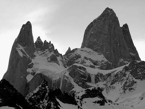
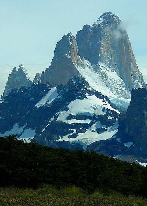
The Aguja Poincenot is located in the northern part of Parque Nacional Los Glaciares, in Argentinian Patagonia. This granite spire is part of the FitzRoy range that stretches (south to north) from Cerro Techado Negro (2152m) to Cerro Electrico (2257m). Its closest neighbor is the world-famous Cerro FitzRoy (3375m - also known as Cerro Chalten).
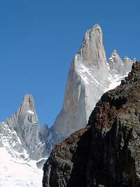
Photo by poice2004
Aguja Poincenot was named after the French alpinist Jacques Poincenot who drowned in Rio FitzRoy in 1952. A French expedition went to this region that year to conquer the nearby FitzRoy. On the first day of walking towards the base camp, Jacques Poincenot fell into Rio FitzRoy and died. Rough experience for his fellow members.
However, they decided to carry on with the expedition. Eventually, Guido Magnone and Lionel Terray managed to reach the summit of FitzRoy. And to keep the memory of the presence of Jacques Poincenot in the team, they decided to give its name to the elegant spire located South of FitzRoy.
It's only 10 years later that Aguja Poincenot was conquered in 1962 by Frank Cochrane (IRL) & Don Whillans (UK). Nowadays climbers come here mostly to ascend FitzRoy, and routes on Aguja Poincenot have far fewer visitors.
NB : Aguja means Needle
Getting There and Staying

El Chalten

FitzRoy area

Rio Blanco base camp

FitzRoy area
ACCESS
There are two ways to access El Chalten :
The most common is by bus from El Calafate. There are 1 or 2 buses per day, taking 4 hours.
Two companies run this service : CalTur and Chalten Travel.
Second solution : you can come from Villa O'Higgins in Chile (southern end of the Carretera Austral) by boat (once to twice a week) across Lago O'Higgins. Then hike for 25 kms and take a second boat on Lago del Desierto. From there, there is an evening bus to El Chalten. All details on this incredible crossing : Cruce VOH a El Chalten.
LODGING
As far as accommodation is concerned, there are several youth hostels and campsites in town. One I can recommend that offers both beds and campgrounds is El Refugio, located on the main street (6$ per night and per bed / 2$ per night and per person in tent). Kitchen facility and hot shower included in the bed price.
BASE CAMP
To reach the base camp of Aguja Poincenot, you need to take the trail goes towards Laguna de Los Tres. Shortly after having gone through Campamento Poincenot (campground for hikers) you will reach Campamento Rio Blanco (meant for climbers - alt. 750m). About 2h/2h30 are required for this campground.
A higher camp is then set up at the Paso Superior (Higher Pass) at about 2000m. From there the ascent starts. To reach the Paso Superior from Campamento Rio Blanco, you need hike up to Laguna de Los Tres first (alt. 1160m) then walk on the left shore. Once on the other side of the lake, ascend the steep slope to reach the Paso Superior.
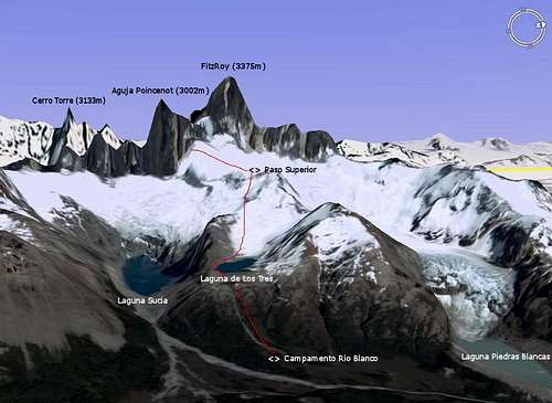 Access to Aguja Poincenot
Red Tape and Weather Conditions

Laguna de Los Tres covered in snow (early spring)
Aguja Poincenot is part of the Parque Nacional Los Glaciares. A permit is required to ascend this peak. You can obtain it at the main office in El Calafate.
As any protected area, it is forbidden to camp outside the campsite, or lit fires. Take all trash away with you.
Be aware that in Patagonia the weather can change brutally. From warm sun to snowstorm in a few hours of hours, any time of the year. Take warm and waterproof clothes with you, and be ready for tough conditions. The best time to climb would be between December to February, but there can be stronger wind during these months.
Climbing Routes
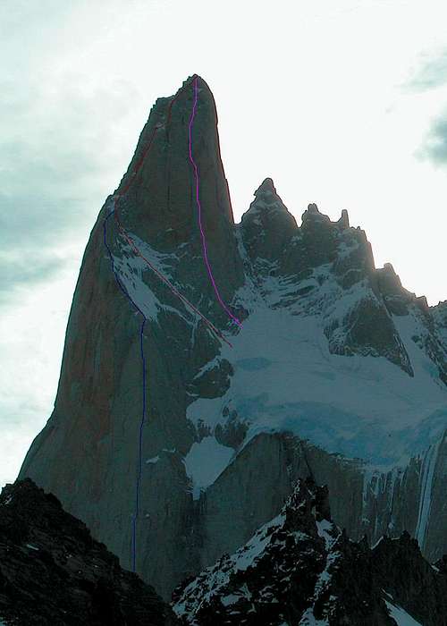
Routes on East Face
EAST / SOUTHEAST FACE
o Normal Route SE ridge (600 m TD) by Frank Cochrane (IRL) & Don Whillans (UK) in 1962
o Southeast Pillar (1300m ED+ 7a/A3) by A. Bortoli, A. Carnati & M. Colombo (ITA) in 1986
o Patagonicos Desesperados (600m ED 6c/A3+) by Daniel Anker & Michel Piola (SWI) in 1989
o Whisky Time (700m ED+ 5.11+/A4) by B. Eggler & M. Pitelka (SWI) in 1994
SOUTH / SOUTHWEST FACE
o Normal route (1200m TD) by José Luis Fonrouge & Alfredo Rosasco (ARG) in 1968
o Endless Story (1000m ED+ 6c/A3) by Fernando Cobo & Murcia Murcia (SPA) in 1987
o Judgement Day (1200 ED 5.11/A1) by S. Gerberding & J. Smith (USA) in 1992
o Bagual Bigwall (1300m ED+ 5.11/A3) by M. Schwitter & A. Maag (SWI), M. Ishibe & A. Portela (BRA) in 1995
WEST / NORTHWEST FACE
o Normal route (800m TD) by Rab Carrington & Alan Rouse (UK) in 1977
o Northwest Pillar (700m ED 6c/A2) by Daniele Bosisio, Mario Panzeri, Marco Della-Santa & Paolo Vitali (ITA) in 1986
NORTH FACE
o Le Vieux Contrebandier (700m ED 5.10+/A2) by G. Crouch & J. Donini (USA) in 1996
Useful information
South Face
Book :
One guidebook with a little information about this peak is :
The Andes : A Guide For Climbers by John Biggar - Jul. 2005
ISBN : 0953608727
Map of the area :
Monte Fitz Roy & Cerro Torre
Scale > 1:50.000
ISBN : 1879568292
Weather forecast :
On Infoclima > El Chalten
Internet :
Official website for El Chalten : Capital Argentina del Trekking
Official website of the National Park : Parque Nacional Los Glaciares
Excellent general information on Aguja Poincenot (in French) : Expé.com