
|
|
Mountain/Rock |
|---|---|
|
|
40.27813°N / 105.59876°W |
|
|
Latimer |
|
|
Hiking |
|
|
12044 ft / 3671 m |
|
|
Overview
Battle Mountain gets overshadowed by it's more impressive neighbors to the southwest, Mount Lady Washington and Longs Peak, and therefore is generally overlooked by most people. But Battle Mountain does offer something you can't get from most other locations, a very nice view of Storm Peak, the Keyhole, Mount Lady Washington, Longs Peak and Mount Meeker. Additionally there are some nice views of the Mummy Range to the north, Hallett Peak,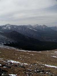 Looking off to Hallet Peak, Half Mountain and Bear Lake to the northwest of Battle Mountain's summit
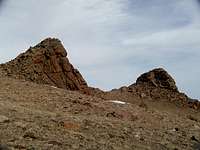
Battle Mountain was named by Enos Mills after the intense storms he witnessed brewing over the broad, flat summit. Battle Mountain is generally quite flat, but has three slightly rocky summits, starting just a short distance from Granite Pass and trending off to the northeast. The third such rocky outcrop is the true summit of Battle Mountain, however the summit of Battle is only about 44 feet higher than Granite Pass.
Getting There
Battle Mountain is in Rocky Mountain National Park. And there are a couple of different ways to getting to the summit. The shortest way to the is via the East Longs Peak trail. Start at the Longs Peak Trailhead and hike the 4 miles to Granite Pass. At the trail junction to the Boulder Field, continue north on the North Longs Peak trail for less than a half mile, and head east across the tundra before the trail starts heading downhill. The third rocky summit is in plain sight and easy to get to over the flat tundra. Red line is the East Longs Peak Trail to Battle Mountain. The blue line is the Jims Grove variation.
A slightly longer way to get to the summit is to start at a couple of different trailheads along Bear Lake Road in the Glacier Creek valley. You could start at the Bear Lake parking lot, and follow the Glacier Gorge trail past Alberta Falls and then follow the North Longs Peak trail to just short of Granite Pass. Or you could start at the Boulder Brook trailhead and follow it south till it junctions with the North Longs Peak trail. The Boulder Brook option is slightly shorter with a total one-way distance of about 5 miles. Starting at Bear Lake adds about half a mile to that.
The southern slopes of Battle Mountain are quite gentle, and if you follow the somewhat abandoned Jims Grove trail you can approach the summit by a much less traveled route by first following the trail, but shortly after breaking out of the trees, look for the two rocky outcroppings
For more adventuresome folks, making the climb up the eastern flank from the Eugenia Mine or the northeast ridge from Storm Pass are options as well to getting to the summit or as possible descents.
Red Tape
Since Battle Mountain is in Rocky Mountain National Park, all the parks regulations are in place.For a list of park regulations click on Rocky Mountain's web site.