
|
|
Mountain/Rock |
|---|---|
|
|
31.91906°N / 107.71755°W |
|
|
Luna |
|
|
5802 ft / 1768 m |
|
|
Overview


North Peak, also known as North Sister, is the northernmost summit in the Tres Hermanas (Spanish for “Three Sisters”) Mountains, a small range in southwestern New Mexico. The peak lies about 8 miles north-northwest of the small town of Columbus. While North Peak’s elevation of 5,802 feet isn’t anything to get excited about, its prominence of 1,512 feet assures the mountain a coveted spot (80th) on the list of New Mexico’s 100 most prominent peaks. North Peak’s nearest neighbors are Middle Peak (or Middle Sister, elev. 5,786 ft.) and South Peak (or South Sister, elev. 5,630 ft.). These pyramid-shaped peaks, lined up in a northwest to southeast orientation, are quite prominent when approaching from the north on New Mexico Highway 11.
The summit affords great 360-degree views of the surrounding Chihuahuan Desert terrain and numerous mountain ranges. Among the mountain ranges visible from the top are the Florida Mountains to the northeast and the Cedar Mountain Range to the west. The Potrillo volcanic field can be seen to the east, as well as the communities of Deming to the north and Columbus, NM and Puerto Palomas, Mexico to the south. As a bonus, there are three benchmarks on the summit and you don't have to send out a search party to find them - they're in close proximity with one another and in plain view.

Columbus, New Mexico
Columbus is a small town 3 miles north of the United States-Mexico international border. This small town captured the attention of the nation after 500 Mexican rebels, under the command of General Ramon Banda Quesada and on orders of revolutionary leader Francisco “Pancho” Villa, crossed the border and raided the town on March 9, 1916. There were 24 U.S. casualties, 14 soldiers and 10 civilians. In addition to the human toll, the town itself was set afire and suffered significant damage. Villa’s force suffered 80 casualties.Getting There
Exit Interstate 10 at Deming, New Mexico and proceed south towards Columbus, New Mexico on NM Hwy 11 for about 24.1 miles. During this leg, aside from seeing a lot of green and white U.S. Border Patrol vehicles, the “Three Sisters” -- North, Middle, and South Peaks -- will be in plain view ahead of you. You should see a dirt road to the right (North Peak will also be to your right) with a green metal gate. Do NOT turn here. Proceed about 2.5 miles further south from this road and there will be another dirt road, this one without a gate. If you get bored or tired, try counting the Border Patrol vehicles (it’s better than falling asleep at the wheel)…but don’t miss your turn!Turn right here and reset your odometer. NOTE: The intersection for County Road B-005 is opposite NM Hwy 11 from the dirt road where you will turn right, so if you see the CR B-005 marker, you’re in the right place.
- Proceed west on the dirt road towards the Tres Hermanas Mountains. At 0.4 miles on the dirt road, the road will split. Veer to the right (left goes to private property).
- At 1.3 miles, veer to the right.
- At 1.6 miles, the dirt road splits but merges after a short distance. Veer right at this split as the left side is very rough.
- At 1.8 miles, turn right and proceed north. This section of the road gets pretty rough. There is also deep dirt and sand.
- At 2.9 miles, turn left, heading directly towards North Peak.
- At 3.3 miles, turn right, proceed about 0.2 miles to the end of the road. This will put you 0.5 miles east of North Peak’s summit.
NOTE: This road gets rough, has moderate grades in places, lacks room for maneuverability, and has deep, loose dirt and sand. 4WD/high clearance is a must.
Route to Summit
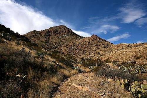
Getting to the top of North Peak can be interesting and also challenging, depending on which route you take. There is no trail that I saw. The cacti density is moderate and the shrubs are dense in areas. There are also areas, particularly early on in the route, where you’ll need to jump boulders and hop rocks. There is some bushwhacking, but not too bad. I recommended wearing gaiters to keep stickers and thorns out of your shoes and socks. I didn’t wear gaiters, which is why I am recommending them now.Immediately south of the end of the road is a good place to start. There’s a draw running towards the mountain that provides a good route reference, either in the draw or to either side depending on the surrounding terrain. Work your way west towards the mountain and determine the best route for you.
I ascended via the east slope through “The Chute.” This was the most direct ascent, highlighted by 150 vertical feet of scrambling (some exposed) that ended about 200 vertical feet below the summit. This is not the safest route.
My descent was via the north face, which although a little longer than the east route, was much safer than trying to descend through “The Chute.” After about 200 vertical feet descent down the north slope, I worked my way to the east and then around to the east side of the mountain to the draw, then further east to my Jeep.
East route (“The Chute”) is 0.6 miles one-way and the north route is 0.9 miles one-way. Net elevation gain for both routes is 1,140 feet.
 Looking up the east slope. Looking up the east slope. |
 Down "The Chute." Down "The Chute." |
 Summit view to south. Summit view to south. |