
-
 9571 Hits
-
 87.76% Score
-
 25 Votes
|
|
Mountain/Rock |
|---|---|
|
|
37.69190°N / 119.0113°W |
|
|
Hiking |
|
|
Spring, Summer, Fall, Winter |
|
|
8250 ft / 2515 m |
|
|
Overview
The Inyo Craters (~8,250’) immediately north of Mammoth Mountain are funnel-shaped cones filled with water and belong to the Mono-Inyo Craters chain of volcanoes that stretches about 30 miles from Mammoth Mountain at the east side of the Long Valley Caldera north to Mono Lake.Geological History
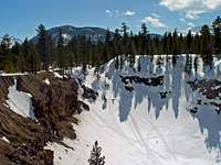
The two southernmost Inyo Craters (North and South Inyo Craters) were formed about 500 years ago when magma rising along a dike heated groundwater, which violently released its pressure in form of steam (phreatic) explosions that blasted the craters from the existing rocks. Several million tons of rock debris were spewed out onto the surrounding pumice-covered land. No magma reached the surface at these events. The walls of the craters consist of near-horizontal layers of basalt lava, andesite tephra, and tephra erupted from other Inyo Craters during earlier eruptions. The basaltic lava flows came from eruptions from between 200,000 and 100,000 years ago, well before the Mono-Inyo chain of volcanoes became active. The andesitic tephra is more than 64,000 years old.
Hike
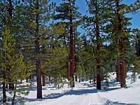
The ¼ mile hike from the parking area leads through a beautiful Jeffrey Pine forest to the two smaller craters. There is a little picnic area on the crater rim. Each crater is about 600 feet across; the southern crater is about 200 feet and the northern about 100 feet deep. Both are filled with small, fish-less lakes. There is a use-trail that circles the entire southern crater. On top of Deer Mountain (8,796’) immediately north of the Inyo Craters is another crater. In winter the entire area from the Mammoth Scenic Loop to the parking area and further up the craters are very popular for snow-shoeing, cross-country skiing, and snow-mobiling. In fact some of the dirt roads in winter are part of the Mammoth Adventures Snowmobiling trails. Some caution is advisable since some snow-mobilers can be quite reckless in their driving. In the summer this area is very popular with mountain-bikers.