
|
|
Mountain/Rock |
|---|---|
|
|
47.88410°N / 123.3662°W |
|
|
Jefferson |
|
|
6753 ft / 2058 m |
|
|
Overview
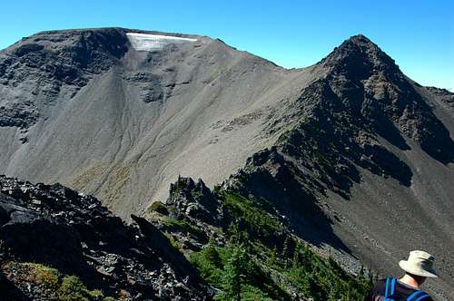
Moose Peak, otherwise known as Peak 6753, is found above Grand Valley and Lillian Valley along Lillian Ridge within the Olympic National Park. This is one of the best high country ridge hikes to do with nearly any age group or fitness level up with incredible views of the inner Olympics, including Mt. Olympus along the entire trail.

To get to Moose Peak, you start at the end of Obstruction Point road, elevation 6150-ft. Follow the Grand Pass trail that undulates along the Lillian Ridge to the Grand Valley trail cut-off at 2.1 miles, elevation 6450'. You may continue down the to Grand Valley into mosquito territory or cut right at the sign post, staying high along Lillian Ridge. Continue what is now a "people trail" (having been discovered over the past few years), heading south toward Moose Peak.
Most people look at you from the main Grand Pass/Valley trail but few try to follow. Along this trail is tranquility with never-ending views on a beautiful day. There is a gentle dip then rise shortly after leaving the main trail. At the first rise there is minimal scrambling whether you venture west or east to ascend the rise. The trail continues over a good camping area that has the only shelter from foul weather. Continue SE following the obvious trail that again undulates until you get to a jagged rock spine.

Stay on the west side of the spine to a point that has been tamed by Man and easily drops easterly to a point just below the rocky crags. Again follow the obvious traverse under the rocks until the slope becomes gentle and you can clearly see the ascending path to the ridgeline that leads to Moose Peak. Ascending in snow is much easier than the high summer scree slope, but easily done. Once on the ridge, follow the obvious trail to the summit. There is a fabulous rock bench to rest upon, have lunch, look for animals and plan your next loop hike!

Green Trails Map No. 134S: Hurricane Ridge/Elwha North
Getting There
Olympic National Park is located in the NW corner of Washington State on the Olympic Peninsula.From Seattle, either take a Washington State Ferry from the waterfront at Coleman Dock to Bremerton or Bainbridge Island. You may also choose to drive South to Tacoma on I-5. Take the Gig Harbor / Highway 16 exit and follow to the Hood Canal Bridge.
From Bremerton, make your way to Highway 3 heading northbound toward the Hood Canal Bridge.
From Bainbridge Island, make your way west on Highway 305 to Poulsbo. Take the on-ramp to Highway 3 toward the Hood Canal Bridge.
Cross the Hood Canal Bridge on Highway 104 and follow the signs to Port Angeles, Washington. Hwy 104 merges onto Hwy 101 prior to Port Angeles.

Red Tape
This is within the Olympic National Park, therefore one needs a Olympic National Park Annual Pass, Golden Age Passport, Golden Eagle Passport, 7 day pass or National Park Pass. Fees may change yearly.Overnight Passes are required for staying over night in the Olympic National Park.
Permits and Reservations are required when staying in Grand Valley.
NO DOGS ON THE TRAILS!!!!! I have encountered 2 groups of humans attempting to hike with their canine buddies. This is a no-no. Pets are not allowed on the trails, must be on a leash in the parking lot area, poo-poo must be picked up and placed in a garbage can and pets cannot be left unattended at the parking lot, cannot be left tied off to vehicles, trees, etc. at the parking area
Camping
Overnight camping requires a permit from the Olympic National Park.External Links
http://www.olympic.national-park.com/When to Hike
The Obstruction Point Road is open from late Spring when snow melt has occurred, until the first road covering snow of the Fall. When the road is closed, Hurricane Ridge road is typically open on weekends when the road has been cleared and the Obstruction Point Road is an excellent place to snowshoe, cross country ski and explore.Images


bmwboarder7 - Jun 22, 2009 1:55 am - Hasn't voted
coordinatesCould you change the latitude/longitude coordinates to be accurate? Clicking on that link takes you to Asia instead of to the Olympics. Thanks!
tleaf - Jun 22, 2009 10:48 pm - Hasn't voted
Re: coordinatesSheesh. Do you want to find it? I am sooooo sorry. Truly I am. I had the longitude as a positive # instead of a negative! I didn't even realize it! Thank you for pointing it out. Cheers, Trina