
-
 58447 Hits
-
 87.3% Score
-
 24 Votes
|
|
Mountain/Rock |
|---|---|
|
|
46.51207°N / 114.24492°W |
|
|
Ravalli |
|
|
Hiking, Mountaineering, Skiing |
|
|
Spring, Summer, Fall, Winter |
|
|
9351 ft / 2850 m |
|
|
Overview
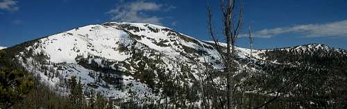 Summit panorama
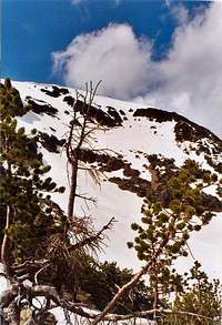
Saint Mary Peak is one of the most accessible 9,000+ ft peaks in the Bitterroot Mountains and offers spectacular views. There is a well-worn trail to the summit, gaining 2500 feet of elevation in 3.5 miles. The trailhead, the loftiest in the Bitterroot Mountains, is at 6850 feet! On a clear day, you can easily pick out the mountains of the Mission, Swan, Rattlesnake, Garnet, and Lewis and Clark Ranges to the north and northeast, the Sapphires and John Day Mountains to the east, The Flint Creek and Anaconda Ranges to the east and southeast, The Beaverhead and Bitterroot mountains to the south, and the low but rugged Clearwater mountains in the west. In summer, St. Mary is an "easy" day hike along a well-maintained trail and is a suitable peak for strong children (7 year olds have stood on the summit! ). The lookout at the top is staffed and operational during the fire season (usually July - October), and the staffer doesn't mind visitors. In the spring, the peak offers excellent ski opportunities in its many bowls as well as varying levels of difficulty.
 Lookout tower
St. Mary carries 2,000 feet of prominence. Note: The name of this peak is a singular noun: "Saint Mary Peak," not be confused with the plural version in the nearby Mission Range, "East Saint Marys Peak."
Trailheads and Access
St. Mary Peak Trailhead Usage: Medium Facilities: Restrooms, parking for several vehicles, No drinking water is available at trailhead. No garbage facilities. Water can be found at a spring along the trail. Directions: From the Stevensville, MT cutoff (next to Super One Foods), go south on US Hwy 93 for 3.6 miles to Indian Prairie Loop. Look for Forest Service Trailhead signs. Turn right (west) and travel 1.3 miles to St. Mary road. Turn right (north) and go for .5 mile, taking the first left (west) onto FR 739.
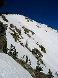
In less than a mile the road forks. Take the right (north) fork onto St. Mary Peak Road. Follow it for 10.3 miles to its end. You will pass a couple of unsigned turns before reaching the end. Stay to the left both times. The trailhead is accessible year-round by snow machine, and seasonally by vehicle, typically ~May through ~November of most years. The approach From the trailhead, 99% of parties follow the well-maintained trail 3.5 miles to the summit. Along the lower third of the trail is a spring that one can use to fill up water bottles. The spring is off the left side of the trail and has been modified with an old trough. This is a good place for a "shake down" break and to get ready for the climb ahead. The trail slowly gains elevation before it starts traversing along the saddle of the southeast ridge, where the summit comes into view. After this the trail switchbacks relentlessly along the open south face and along the southeast ridge to the summit. One of the unique features of this climb is the open-air toilet situated somewhat between the summit benchmark and the lookout tower, overlooking McCalla lakes and the Bitterroot Valley. It is probably the most amazing view you'll ever have while sitting on the toilet! (The primary purpose, of course, is to be utilized by the lookout volunteer).
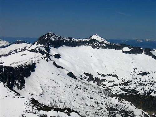
![Heavenly Twins]() Heavenly Twins from the summit
Heavenly Twins from the summit
![South Bowls]() Summit from the south
Summit from the south
Weather and Avalanche Conditions: missoulaavalanche.org forecast (~November through ~March) National Weather Service in Missoula National Weather Service Automated Surface Observation Stations (SNOTEL, RAWS, etc) Local Web Cams: Ridgeway Pharmacy Webcam in Stevensville This webcam is user controllable USFS Airquality Webcam near Stevensville shows area around Little and Big St. Joseph peaks, Gash Point, etc. Gives a good idea of the area weather. Bitterroot SNOTEL sites: Saddle Mountain, 7900', near Lost Trail Pass Nez Perce Camp, 5650' west of Darby Twin Lakes, 6400', near Lost Horse Lolo Pass, 5240'
![TOPO! St Mary]() TOPO! of summit area
TOPO! of summit area
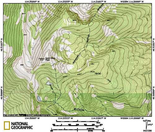
![TOPO! St Mary area]() area map
area map
 Heavenly Twins from the summit
When to Climb
You can usually drive to the trailhead from May through November. The trail follows the south side of the ridge, and is snow-free for most of the summer. Winter access is more limited, as the trailhead is at 6850 feet and some portions of the road have a north exposure. In late fall or early spring, snowpack on the road may make the trailhead unreachable in a vehicle. It is possible to park along the road at a lower location, and then ski up the road, or take a more direct skin/snowshoe route up the ridge to the trailhead. Generally, winter conditions along the first 2 miles of trail are good for skiing. Above the wilderness boundary, the trail is quite windblown, and it's usually easier to take a direct route up the ridge. Above 8000 feet, expect varying snowpack and windblown drifts, as well as possible icy slopes, depending on conditions. Winter winds often sweep most of the accumulated snow from the upper 1000 feet of the mountain .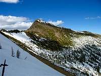 Summit from the south
Activities
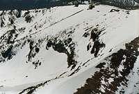
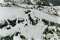
Camping Adhere to National Forest and Wilderness regulations - dispersed primitive camping is available. NO CAMPING in lookout tower or at trailhead. Leave no trace. Hiking St. Mary's provides spectacular views and is a popular summer destination for it's relatively easy approach to a 9,000 foot summit. Day hikes are the most common activity. St. Mary is a great destination for aspiring mountaineers. Skiing St. Mary is a favorite destination for backcountry spring skiing. There are numerous lines and ample places to camp. McCalla Lakes basin is an excellent place for your weekend base camp. For purposes of SP, we'll divide the skiing into four main areas: Northeast Bowl: The northeast bowl is accessed by walking north along the ridge from the summit lookout for a couple hundred feet. Picking a line here is daunting, as the slope is 40-45 degrees in places near the top. Angling skier's right during the descent, one should make it over to the ridge between this and the southeast bowl for the easiest (shortest!) escape route. Southeast Bowl: The southeast bowl is accessed along the southeast ridge leading to the summit. This bowl contains one major pitch and careful route-finding at the bottom will allow one to cross the saddle back to the trail without gaining any elevation. South Bowls (McCalla Lakes Basin): The south bowls can be accessed from the summit in early season, by traversing along the snow-free southwest ridge in late season, or by climbing directly from the Upper McCalla Lake. Excellent camping can be found here and most descents will allow you to ski right up to your tent. Here I have found the most consistent spring corn; the northeast bowl was avalanche-prone with wet slabs during our last visit but the south bowl were absolutely perfect! West Bowls: The west bowls can be accessed by crossing the divide between the south and west bowls and traversing around towards point 8990. This is the most remote skiing as it will necessitate climbing back into the south bowls to escape.
 southeast bowl southeast bowl |
 northeast bowl northeast bowl |
 south bowl south bowl |
 west bowl west bowl |
|---|---|---|---|
 east bowl aerial east bowl aerial |
 northeast bowl entry northeast bowl entry |
 south bowl lines south bowl lines |
 south bowl skiing south bowl skiing |
Current Conditions
Facebook:
Search for "The Real Ski Season" for occasional road updates in the spring.
Maps
 TOPO! of summit area
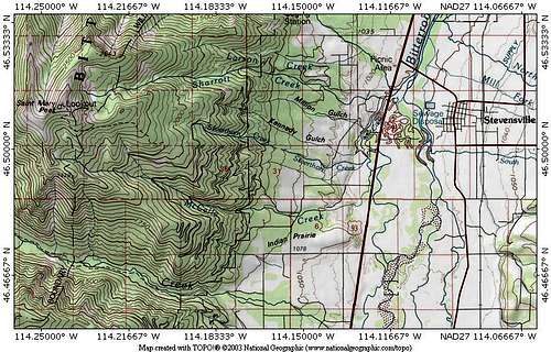 area map