
-
 18202 Hits
-
 75.81% Score
-
 6 Votes
|
|
Mountain/Rock |
|---|---|
|
|
46.85843°N / 121.66191°W |
|
|
Pierce |
|
|
Scrambling |
|
|
Spring, Summer, Fall |
|
|
7211 ft / 2198 m |
|
|
Overview
Meany Crest is the summit overlooking one of the most scenic campgrounds in all of Mount Rainier National Park, Summerland. It is a moderate Class 2-3 scramble over broken boulders and snowfields. While fairly cliffy and impressive looking from Summerland and near Panhandle Gap, Meany Crest is merely the termination point on the ridge radiating down from Little Tahoma Peak. Accordingly, Meany Crest is often passed on the approach to the Frying Pan Glacier and Little Tahoma.With the popularity of Summerland and its location directly on the Wonderland Trail, Meany Crest and the higher summit to its west are probably ascended fairly regularly. Meany Crest affords beautiful views of Panhandle Gap, Little Tahoma, the lower Emmons Glacier, and the entire Sunrise area of Mt. Rainier.
Getting There
 Meany Crest from Summerland
 Rainier from Summerland
 Meadows before Footbridge
 Footbridge across Fryingpan Creek
Take the Frying Pan Creek Trail 0.1 miles to its junction with the Wonderland Trail. Take the left junction of the Wonderland Trail towards Summerland (in another 4.1 miles). This trail is like a highway, wide and smooth, with barely a rock or a root. You can walk three abreast on some parts. National Park hiking at its most comfortable.
Climbing Route
 Break in Cliffs
 Skirting the Cliffband
 Final Climb to Summit
 Rainier from Summit
Camping and Red Tape
 Meany Crest from above Summerland
 Meany Crest from trail to Panhandle Gap
 Banshee Peak and Cowlitz Chimneys
 Western Pasqueflower in Summerland
An entry fee is required to enter Mt. Rainier National Park. The cost is $15/vehicle per week. You can also buy an annual U.S. National Park Pass for $80, which is also good at all Northwest Forest Service trailheads. Other than this, there appears to be no restrictions on camping at Summerland or hiking the trails/climbing the summits in the area.
External Links
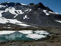 Meany Crest rises above Alpine Tarn
 TOPO! Software Image
Another great site is this excellent Mt. Rainier climbing blog, which gives up-to-date snowpack and road conditions on Mt. Rainier and the all of the roads: Mt. Rainier Climbing Page