
|
|
Mountain/Rock |
|---|---|
|
|
36.46380°N / 50.92588°E |
|
|
Mountaineering |
|
|
Summer |
|
|
13583 ft / 4140 m |
|
|
Overview
Click for Introduction to Central Alborz Mountains.Click to see the Map of the Takhte Soleyman Massif.
Important note about name and elevation: Mazi Gardan sits in a remote part of the Takhte Soleyman Massif. Neither the Iranian nor the Soviet 1:50 000 Map show the topography of this area very accurately. The name "Mazi Gardan" appears on “The Guide Map of Takht-e-Soleiman & Alam Kuh Region” (which is not a topographic map, but a schematic cartoon-like map). The 4140 m elevation is per my own GPS measurement. I am not aware of any other source that provides any information about this peak.
 South Face
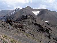 North Face
 East Face
Mazi Gardan is the northern-most 4000 m peak of the Takhte Soleyman Massif. It also has the distinction of being the closest 4000 m peak to the Caspian Sea. Only 32 Km (19.8 miles) separate the summit of Mazi Gardan from the Caspian Shore which is 25 meters below sea level.
Mazi Gardan rises on the crest of a ridgeline that forms the northern arm of the Takhte Soleyman Massif. To the south, Mazi Gardan is connected to the 4340 m Looy Na Peak and to the north it is connected to the 3953 m Shoor Gardan Peak. The western slopes of Mazi Gardan drop very steeply 2500 vertical meters to the bottom of the Sehezar River Valley and its eastern slopes drop 2000 vertical meters to the bottom of the Eza Rood River Valley. Both of these valleys are covered by Caspian Forests up to an elevation of 2300 m and are often filled with clouds generated by the Caspian Sea moisture.
 North Face, photo by fereidounforghani/Amirkhani
A huge pit sits at the base of the Mazi Gardan on the south side of it. My guess is that this pit is roughly 75 m deep and 200 m across. I found it very odd that no lake had formed at the bottom of the pit.
 The Pit
Mazi Gardan is a long way from any trailhead and reaching its summit requires a multi-day program. It is best approached via the 4430 m Ghobi (and then Looy Na) Peak. To descend into the Caspian Forests, from the summit of Mazi Gardan, you will have to follow the mentioned ridgeline north. This ridgeline gives rise to 6 major peaks that can be climbed as an added bonus (see footnote below for the names of these peaks). After a 20 Km hike from the summit of Ghobi you will reach the seasonal village of Kia Neshinan (2400 m) which sits just above the edge of the forest. This village is inhabited only in summer (when we reached the village on June 22, there were only 3 young men in it).
 Just above the forests Just above the forests | 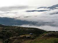 Village of Kia Neshinan Village of Kia Neshinan |  Into the Forests Into the Forests | 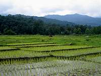 Coastal Plain Coastal Plain |
To reach a road to take you to the Caspian coast, from Kia Neshinan, you will have to hike down through the forest to another village named Gaznachal (1900 m). After Kia Neshinan, we became hopelessly lost in the dense fog and the crisscrossing network of trails/semi-trails and in the end had to ask a young man from Kia Neshinan to guide us one hour (4 Km) through the forest to take us to a nearby logging road (2000 m) where we were lucky to catch a ride (2.5 hrs through the dense forest) to reach the coastal town of Tonkabon.
 From Looy Na
Views from the summit of Mazi Gardan:
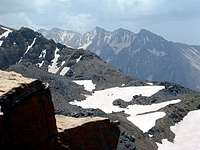 Haft Khan Peaks Haft Khan Peaks |  Eza Rood Valley Eza Rood Valley |  Ghobi Peak Ghobi Peak |
 Sehezar & Siyalan Sehezar & Siyalan | 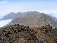 Shoor Gardan Shoor Gardan |  Korma Kooh Korma Kooh |
Footnote:
Names and links (to be made) for the peaks on the mentioned ridgeline (south to north): 1) Looy Na 4340 m, 2) Mazi Gardan 4140 m, 3) Shoor Gardan 3953 m, 4) Reka Poshteh 3640 m, 5) Dakooh 3590 m and 6) Peak 3483 m.