
|
|
Mountain/Rock |
|---|---|
|
|
39.71719°N / 77.91101°W |
|
|
Hiking |
|
|
Spring, Summer, Fall, Winter |
|
|
1548 ft / 472 m |
|
|
Overview
 View east from clearcut
The northern half of the mountain where the summit is located had no real views other than a limited view from a gasline clearcut
that crosses the mountain. This is the same clearcut that crosses Rickard and Sword Mountain and ends at Hearthstone Mountain to the west. However it is a nice walk through oak forest along the ridgeline.
The mountain has no trails other than old logging roads and the clear cut that crosses it. So is it worth hiking? If you enjoy nature then yes. If you soley want views then no.
Getting There
DirectionsFrom I-70, take the Clear Spring exit and travel north on Route 68. Cross Old Route 40, bearing left onto Mill Street. Continue to a fork and bear right onto Broadfording Road going east approximately 1 mile. Take the first left onto Blair's Valley Road. The entrance to the Indian Springs Wildlife Management Area is approximately 3 miles north. For more information, contact the Indian Springs Wildlife Office at (301) 842-2702.
You can park at the WMA and climb over Rickard Mt. then over to Powell, or just before the WMA is Polecat Hollow Road where you can turn north and park along the old dirt road and hike east to the ridgeline from there.
Red Tape
 resting on the ridge
 Rocks on the ridge
 The ridgeline
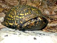 Eastern Box Turtle
Camping is only allowed at the camping area at the Indian Springs WMA headquarters. For information about camping at Indian Springs, please contact the office at 301-842-2702. No campfires allowed.
Is it private or not? I would recomend hiking from the Wildlife Management Area, and if you see posted signs avoid that section or get permission. We saw very few posted signs on Powell and those we saw where in Polecat Hollow to the south, and at the very north end of the ridge after coming down from the summit and entering PA.
Topo Map
 Powell Mountain Topo
Timmus - Jan 21, 2024 3:00 pm - Hasn't voted
Misleading Information About Access to PowellIndian Springs WMA does not include Powell Mountain, Polecat Hollow, or anything else to the east of a line generally following the ridge of Rickard Mountain. These areas outside the WMA are privately held, and not accessible without express permission from the owner/owners. Please do not encourage people to enter them from the WMA as this places a very heavy amount of trespassers on a small number of land owners. You can say to yourself, what does it hurt just to hike through, but I guess I could say the same about squatting in your house while you’re on vacation as long as no one ever knew?