
|
|
Mountain/Rock |
|---|---|
|
|
47.42520°N / 120.90697°W |
|
|
Scrambling |
|
|
Spring, Summer, Fall |
|
|
6779 ft / 2066 m |
|
|
Overview and Scrambling Routes
Teanaway Peak, pronounced "tea-ANN-away," isn't an official name, and you won't see it on the USGS Topo map. You can find it on the upper-left corner of my topo map as waypoint "TEANWY." I don't know who gets the credit for this informal name. According to Klenke, "Genes Peak" is another name sometimes used for this peak, named for Gene Prater. As a side note, one of the four guys who climbed Teanaway with me goes by "Iron Mike," and we climbed his namesake peak after Teanaway (Genes) Peak.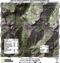 Topo Map
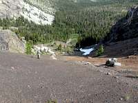 Steep SE Gravel
 Southern Snow Crossing
The standard route follows the trail to the Teanaway-Bill saddle (see topo map and wta.org route description below), and then follows the ridge W-NW until turning SW toward the summit.
Instead of staying on the trail to the saddle at 5850', we became impatient and left the trail around 5630 to ascend the SE gully. The section near the top is on 30-35 degree gravel, and I wished I had my axe out in case I started sliding. We joined the standard ridge route around 6350', and turned SW for the final 2nd class scramble to the summit. The next time I will follow the standard ridge route.
We descended the south side to head for our final summit, Iron Peak. From the summit, we headed straight down, and the initial steep, loose slope was more time consuming than I expected. It would have been better to head more to the left at the start. Lower down, I think around 6300', we came to another difficult spot with two options:1) right across a steep snow patch with no run-out, or 2) left down another gully. Three of us went across the snow, and the other two tried the gully. The gully wasn't too bad, so I would choose that way the next time. Some more 2nd class scrambling led us down to the Teanaway-Iron saddle. As a side note, you can see that we took a shortcut on our descent from Iron Peak. We were able to descend quickly down the loose, but not too steep, slope.
WTA Route Description
From wta.org:
You can hike Teanaway Peak via the Beverly Turnpike trail #1391 or via Iron Peak trail to the Turnike trail junction at 5600 ft. The Iron Peak approach is shorter but has more elevation gain. This description is for the Beverly Turnpike approach.
About 3 miles up the Beverly Turnpike trail reach the junction at 5180 ft. Take the left fork to the Turnpike trail junction at 5600 ft. Continue to the right about 0.4 miles to "Turnpike Pass." Here leave the trail and follow the broad east ridge. The slope is moderate and the open forest presents no difficulties. Stay right of a slabby cliff and proceed to a step in the ridge at ca. 6250 ft. Drop off the ridge to the left down a gully full of loose rocks about 70 ft. and regain the ridge on steep loose gravel at about 6350 ft.
From there it's a straightforward climb to the summit. Scrambling experience recommended. Great views of the entire Stuart Range.
I verified that this description looks accurate, and see that it also spends some time on the steep, loose gravel.