
-
 7957 Hits
-
 85.87% Score
-
 21 Votes
|
|
Mountain/Rock |
|---|---|
|
|
48.13346°N / 113.92167°W |
|
|
Flathead |
|
|
Hiking, Mountaineering |
|
|
Spring, Summer, Fall |
|
|
6948 ft / 2118 m |
|
|
Overview of Birch Point (Point 6948)
 Birch Point from the Alpine #7 Trail
Layout designed for best viewing on a "1024 x 768" screen.
Looking East to the Jewel Basin from the Flathead Valley there are many bumps along the skyline.
One of them, a small highpoint along the western side of the Jewel Basin, is Point 6948. We have named that point Birch Point as the closest named geographic feature is Birch Lake.
Nestled in the center of Montana’s fabulous Jewel Basin, Birch Point (Point 6948) lies above Birch Lake as well as Martha Lake. Home to 27 named lakes that all hold catchable Westslope Cutthroat Trout the Jewel Basin holds a number of peaks that present enjoyable scrambles to their summits.
The Jewel Basin is part of Montana's rugged Swan Range.

|
|---|
Getting There
 From near the summit looking to Martha Lake
Birch Point is located on the western boundary of Montana’s Jewel Basin Hiking Area. This incredible area has been preserved for future generations by farsighted friends of the wilderness. Please see the Jewel Basin Area page for more details.
The Jewel Basin is open all year but due to massive amounts of snow the roads close sometime in late October to mid November and open again some time between the middle of June and the first week or so of July. During the winter season some backcountry enthusiasts snowmobile to the trailheads and either snowshoe or ski into the Jewel Basin. Please keep in mind motorized vehicles including snowmobiles, motorbikes, four wheelers and even mountain bikes are prohibited in the Jewel Basin.
The Jewel Basin is also closed to pack stock including horses, llamas, goats and sheep. Even man's best friend must be on a leash.
Getting to Montana is worth the cost and time.
The Jewel Basin is located with in a short hours drive from the Glacier National Park and therefore it is not surprising that Glacier National Park's peaks can be seen from most of the summits in the Jewel Basin.
The Flathead Valley is served by personal vehicles on Highways 2, 83 and 93. Look for them on the map leading to northwestern Montana.
Amtrak has a scheduled stop in Whitefish, Montana as does the charter bus services. Glaicer Park International Airport (FCA) serves as the center for those who choose to fly here.
All of the national chain of rental car companies can be found both at or near the airport.
Red Tape
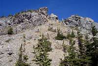
 Birch Point's Northern Ridge
There is little red tape with the exception of a 12 person maximum group size on all trips.
There is a strict "Leave No Trace" policy here as should be expected. Stay on designated trails.
Follow all guidelines for camping in bear country if you plan to camp as black bear and grizzly bear call this area their home. There are also mountain lions in this area.
As with all hiking and climbing in Northwestern Montana use caution and practice good manners with the wildlife. You are in bear country. Carry your bear deterrent, don’t hike alone and make some noise. For more information please go to the Glacier National Park's website for Bear Information. The U.S. Forest Service also has helpful information on Grizzly Bear Management.
Route Information
 Route Map
Directions to the trailhead:
Please visit the Camp Misery Trailhead information for directions to the start of the route.
On Trail Directions:
Upon arriving at Camp Misery take a quick look at the map that is posted on the Information Board and take off up the Jeep Road to the right of the sign that is next to the gated road. Follow that road through a few switchbacks until breaking up onto the ridge above Camp Misery. An interesting side trip can be had by following a trail that takes off to the right. It goes up to a knob and there are nice views there. Continue on the road for another ½ mile or so where you will find another enlarged parking area. Back in the 1970’s we could drive to this point, since then the US Forest Service has closed this road hence the gate at the bottom of the road.
By looking south the foot trail will be seen. Follow that trail to a junction. There are actually 5 trails that meet at this junction. From the trail you are on take the second trail. The sign says Birch Lake. Do not take the Switchback Trail which heads off below the trail you just walked.
Walk on Alpine Trail #7 to Birch Lake. While en-route Martha Lake can be seen below the trail and Point 6948 (Birch Peak) can be seen above Martha Lake.
After reaching Birch take a quick break and make a decision to either head cross country to Birch Point from the outlet of Birch Lake or make a decision to climb from the South via Trail #187.
For South Route via Trail # 187
Cross the log bridges at the outlet of the lake. Continue on Alpine Trail #7 for another mile until reaching the next junction with trail #187. This junction is difficult to see but the trail is obvious. Take a right turn and follow this trail to the saddle between Birch Peak and Squaw Ridge. A few extra yards of walking will reward you with views of the Flathead Valley, but there are better views on the ridge.
For Direct Route to Birch Point
See Off Trail Directions Below.
Off Trail Directions:
 South Route via Trail # 187
 Views into Glacier National Park
For South Route via Trail # 187
When reaching the saddle between Birch Point and Squaw Ridge work your way to the north through the gendarmes that poke out along the south ridge of Birch Point. Enjoyable scrambling in found all along the ridge. Other options include skirting the cliffs and climbing through the alpine slopes to the west of the cliffs. Within a few minutes the small summit will be reached.
 Direct Route to Birch Point
 The Game Trail
For Direct Route to Birch Point
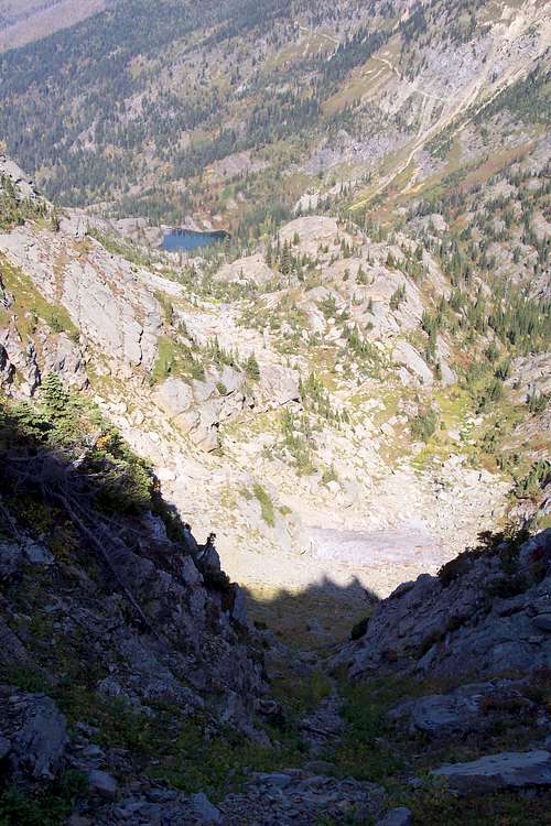
Cross the bridge and follow the use trail along the creek. Follow the ribs of stone that lead up towards the bowl just north of the summit. Head southwest from the bridge through a series of small park-like areas that are incredible to see. Be careful to try and walk on the rocky areas as much as possible. Upon reaching the permanent snowfield to options present for reaching the summit. 1) Climb straight up the scree slope directly toward the summit or 2) Follow the excellent game trail located about 100 yards above the snowfield that leads to the north ridge. From the ridge it is an easy scramble to the summit.
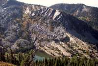 Martha Lake
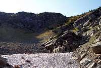 The alpine bowl with the permanent snowfield
Other options for ascent:
Before reaching Birch Lake on Alpine Trail #7 locate a convenient gully and drop down to Martha Lake. After reaching Martha Lake you will find numerous opportunities for scrambling above the lake on the northern ridge of Birch Point. After enjoying the scrambling there work your way up the ridge to the summit of Birch Point.
When to Climb and Weather
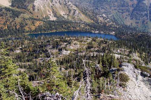 Birch Lake from Birch Point
This climb can be done at any time of the year. If the preference is for no snow plan on doing Birch Point anytime between June 15th and the end of October.
Special Considerations: The rock in Northwestern Montana is widely varied and it is not unusual to find several different types of rock on any given route. Know your rocks and be certain of your safety. J. Gordon Edwards has an excellent section in his guidebook on rock and climbing safety. Be safe and know your limitations as well as those who are climbing with you. Also refer to the following links for further details: GNP Rock and Grading System and the GMS Climbing Guidelines.