
-
 54716 Hits
-
 95.83% Score
-
 55 Votes
|
|
Mountain/Rock |
|---|---|
|
|
44.49320°N / 109.1697°W |
|
|
Park |
|
|
Hiking, Sport Climbing, Bouldering, Scrambling |
|
|
Spring, Summer, Fall, Winter |
|
|
7890 ft / 2405 m |
|
|
Overview

From the southwest

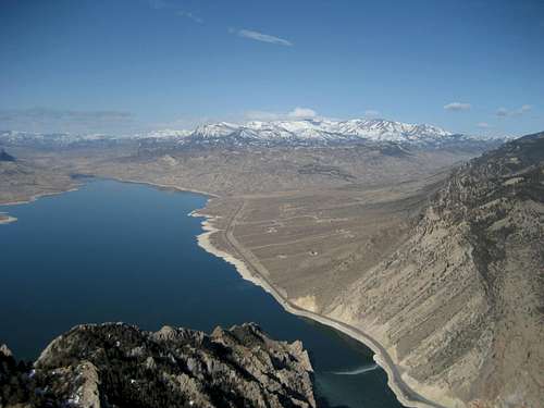
Sheep Mountain across the reservoir
Cedar Mountain, which is also known as Spirit Mountain, is the smaller of the two peaks directly west of Cody, Wyoming. The two mountains are divided by the Shoshone River, which runs through the deep, narrow gorge known as Shoshone Canyon. Buffalo Bill Reservoir is located to the west of Cedar Mountain in Buffalo Bill State Park, and is held in place by Buffalo Bill Dam, which was the tallest dam in the world when it was completed in 1910. William F. Cody, known as “Buffalo Bill,” was a larger-than-life figure in the Wild West and founded the town of Cody in 1896; his Wild West Show was famous throughout the world. Buffalo Bill loved the Cody area and this mountain, and the mystery surrounding his death and burial is a fascinating part of Cedar Mountain's history.
Cedar Mountain is far from being the highest mountain in this section of the Absaroka Range, coming in at only 7,890 feet. Its nearest neighbor, Rattlesnake Mountain, which sits just north across Shoshone Canyon, is over 1,000 higher. However, because Cedar Mountain stands alone and is separated from any other mountains, it ranks 17th on the Wyoming prominence list at 2,480 feet, and it is the only peak in Wyoming under 8,000 feet with more than 2,000 feet of prominence. In fact, all sixteen mountains ranked above Cedar Mountain on the list are over 10,000 feet. The view from the summit looking out over the reservoir into the sea of 12,000-foot peaks and wilderness of the Absaroka Range is nothing short of stunning.
There is a massive cavern system beneath the mountain known as Spirit Mountain Cave; it used to be a national monument, but has since been dropped. There is also a very popular area for bouldering and rock climbing about a third of the way up the eastern side of the mountain.
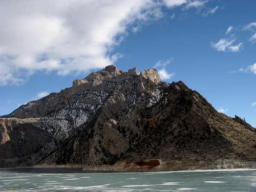
 Buffalo Bill Reservoir and Trout Peak
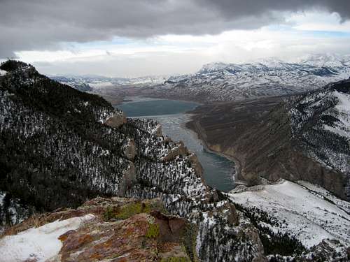 Shoshone Canyon
Getting There and Climbing Information
The easiest route to the summit is via the road that services the radio towers on the both the east and west summits. The main communication site is located on the lower east summit at about 7,650 feet and consists of about a dozen large towers. The west and highest summit also has two smaller towers on it. This road crosses private property, so see the Access and Red Tape section below for more information.

Summit View west

Summit View down into the canyon
From the stoplight in front of Wal-Mart at the west end of Cody, travel west for 1.8 miles and turn left off of the highway onto Spirit Mountain Road. Stay left and begin heading up the mountain on the dirt road. This road is maintained very well, and the only time a 4WD would be absolutely necessary would be in the winter or in snowy conditions. Travel on this road for 2.5 miles until the turnout on the right before the blue gate where the Spirit Mountain Cave sign is in view; this drive will take you from 5100 feet at the base to 6500 feet at the sign. Park here and walk the rest of the way - for the first two miles after the gate, the road crosses private property, so do not leave the road. There is another gate just before you reach the east summit and the large group of radio towers. When the road forks in the middle of the tower area, take the left turn and head west. After passing the last towers, the road veers left and drops 100 feet before continuing up to the summit.
The round trip distance for this route is about 6 miles and covers about 1400 feet of elevation gain on a class 1 trail; the hike is easily done in 3 hours or less. If you park at the base of the mountain and hike the whole way, it would be a 6.0-mile one way walk to the summit with 2800 feet of elevation gain.

Rock pinnacles on the west side

Rock Field on the west side
If you are looking for something much harder, there are options for climbing Cedar Mountain from the west or south. From the Wal-Mart stoplight, travel west for 0.4 miles and turn left to head up the hill. Follow this road around the mountain for 6.2 miles before making a slight right turn onto Bartlett Lane. After a half mile, turn right onto Cedar Mountain Road and follow it to the end. This entire side of the mountain is public land under the control of either the Bureau of Reclamation or the Bureau of Land Management. Go through this gate and head towards the left end of Diamond Creek Dike, which you will have to cross in order to approach the mountain.
There are several fences in the area between the dike and Cedar Mountain, all of which are fine to cross because it is public land. I made two attempts to climb this peak from here; on the first attempt I headed left after crossing the dike and tried climbing up the west side, but I reached a dead end after climbing a steep scree gully up about 1,000 feet. I headed right on the second try and attempted one of the obvious gullies on the south side. It was very slow going over all sizes of rocks, trees, and sagebrush; I got to within a half a mile of the summit and reached about 7200 feet before turning back in thick trees and knee-deep snow with a storm coming in fast. I believe this route would be possible in the summer if you are into scrambling on loose rock and fighting trees.
 Cedar Mountain seen across Buffalo Bill Reservoir
Spirit Mountain Cave

Gate inside the cave entrance

Cave entrance
Discovered by a bobcat hunter named Ned Frost in 1908, Spirit Mountain Cave was designated as a national monument by President Taft the following year. Due in part to the fact that this place is not especially easy to reach, this designation was dropped in the 1940's. The cave was commercially operated for a brief time in the 1950's and 1960's. Today, the entrance is gated off and the key is controlled by the BLM, which requires a permit for entry into cave.
There are likely undiscovered rooms and passageways in this cave, and it is theorized that it might be possible to go all the way through the mountain or down to the Shoshone River. On the southwest part of the mountain, the topographic maps show a cavern entrance at 5980 feet, but this was sealed off with concrete in 1947. During construction of the Shoshone Canyon Conduit (one of the water outlets from Buffalo Bill Dam) through Cedar Mountain in the 1930's, several caverns and passageways containing hydrogen sulfide gas were encountered. To reach the main cave entrance, park at the sign before the blue gate and hike for about a quarter of a mile down the trail.
Graves and Ghosts

Buffalo Bill
When Buffalo Bill died in 1917, he was visiting his sister in Denver, CO. According to his wife, several close friends, and the priest who was with him when he died, he had stated that he wanted to be buried on Lookout Mountain near Golden, CO. The people of Cody, Wyoming were outraged and claimed that he really wanted to be buried on Cedar Mountain. Buffalo Bill's 1906 will clearly describes his wishes to be buried high on Cedar Mountain and there are instructions to erect a massive red stone statue of a buffalo over his grave that would be visible from the town of Cody itself. A later will, written in 1913, left all decisions to his wife, so whether or not he still intended to be buried on the mountain is unclear to this day. His actual grave site was blasted out of the rock on Lookout Mountain, and was eventually covered with a thick slab of concrete after a couple of organized attempts by the residents of Cody to steal the body.
There is a legend that says that several men from Cody actually succeeded in taking a dead body that looked somewhat like Buffalo Bill and switching it with the real body in morgue before the actual burial took place. This is supported and made more plausible by the fact that several months passed between the time that Buffalo Bill died and the time that he was buried, during which time decomposition would have made it easier to mistake one corpse for another. The story goes that they brought the body back and secretly buried it on Cedar Mountain, but we'll probably never know.

Breck Moran headstone
However, if you want to see a grave on Cedar Mountain, continue straight on the road instead of turning left at the main tower site on the east summit and continue to the edge overlooking the Shoshone Canyon. Breck Moran (1907-1954) is buried here; his headstone reads: "Crusader for Wyoming's Development." Moran was an important figure in the early history of the city of Cody, running the Cody Enterprise newspaper, and serving on the Cody Stampede Board. In the 1940's he was one of the founders of the KODI radio station, which is still going strong today. Next to his grave is a small fiberglass statue of a buffalo that stands about six feet tall. This statue was given by the city in Colorado where Buffalo Bill is buried to the city of Cody as a kind of peace offering regarding the fight between the cities over where he was to be buried. There is also an Indian-style grave marker near here where the ashes of world-famous Buffalo Bill impersonator Ebb Tarr, who died in 2007, are buried.

Buffalo statue with Heart Mountain in the background
On a weirder note, there are supposedly many stories about Cedar Mountain being haunted. Hikers have reported hearing footsteps behind them, but upon turning around, there is no one there. These are conjectured to be the ghosts of the people who wandered into the caves and got lost and died in there. This is one of two explanations I have heard about the alternate name Spirit Mountain. The second is that steam used to rise out of openings on the mountain when there were still active geysers in this area over a century ago, and the Native Americans believed that this was the mountain's Spirit escaping. The weirdest claim I have read about is that the mountain is occupied by "little people" - what this means, I have no idea. All I know is that during all of my times on the mountain I have never encountered ghosts or little people!
The Crater
 Looking across the crater
Crater entrance
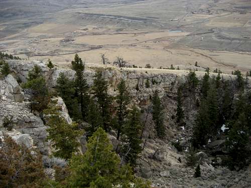
On the south side of the mountain at about 6800 feet, there is a spectacular crater where the side of the mountain caved in. Measuring about 120 yards long, 70 yards wide, and ranging from 50-100 feet deep, its bowl contains a jumble of massive boulders and trees. Reaching the crater is most easily done by hiking due south from the road just before reaching the radio towers; make sure you are above the tall white property marker before leaving the road onto BLM land. This is a bushwhack through the pine trees and a map is a good idea to have in order to come out of the trees at the right place. It is also possible to climb up from below, which entails a scree slog of over 1000 feet.
 Cedar Mountain crater
Buffalo Bill Dam and Reservoir

Visitor's Center

Buffalo Bill Reservoir
The Reservoir to the west of Cedar Mountain was formed when the Buffalo Bill Dam was built. Construction on the dam started in 1905 and was completed in 1910. Its purpose was to provide irrigation water for over 100,000 acres of farmland in the Park and Big Horn counties in the Big Horn Basin. At the time of its completion, the dam was the highest ever built with a height of 325 feet; in the 1990's the top of the dam was raised another 25 feet, which expanded the reservoir's capacity to just over 646,000 acre-feet. The shoreline is about 40 miles long, and the when the reservoir is full, it covers about 8,500 acres. The Buffalo Bill, Heart Mountain, Spirit Mountain, and Shoshone Power Plants below the dam provide about 100 million kilowatt-hours of power a year to Wyoming, Colorado, Kansas, and Nebraska. Another interesting fact about the reservoir is that a small town named Marquette is at the bottom of the lake; all of the land was purchased by the government before construction of the dam flooded the area.
Access and Red Tape

Cedar Mountain sign
Cedar Mountain is a mixture of private land and public land, which is made up of different sections under the control of the State of Wyoming, the Bureau of Reclamation, and the Bureau of Land Management. The road that runs up the east side of the mountain is on BLM land up to the blue gate, which is about 2.5 miles from the highway. This gate marks the beginning of the Sowerwine property, which is the biggest parcel of private land on the mountain. There is another gate after continuing up the road for another 1.6 miles, after which the road enters the Patrick property, which is where the Legend Towers communication site is located. A half mile beyond this gate, the road is back on BLM land all the way to the summit, and the rest of the radio towers to west of the main tower site are there under a lease agreement with BLM.

Blue Gate
There are signs marked "No Trespassing" at both gates, so I called the private property owner to ask permission to cross his property on the road. Elbert Sowerwine, whose massive property covers the majority of the sloping east side of the mountain, was very gracious on the phone and said that neither he nor the property owner of the communication site have any problem with hikers parking below the blue gate and hiking through to the summit, as long as they stick to the road. He did caution me about staying as far away from the towers as possible due to the extremely high amounts of radio frequency energy in that area.
A permit and a key is required to enter the Spirit Mountain Cave, and may be obtained from the BLM Office in Cody, which is located at 1002 Blackburn Ave.
External Links
For more information on William F. "Buffalo Bill" Cody
http://www.bbhc.org/news/BBHChistory_01.cfm
For more on Buffalo Bill's will and the mystery surrounding his final resting place:
http://www.mikeleejohnson.com/BuffaloBillWill.html
http://www.mikeleejohnson.com/BurialPhotoEssay.html
For more information on the Spirit Mountain Cave:
http://www.nps.gov/history/history/online_books/glimpses2/glimpses27.htm
http://gapstone.brinkster.net/spiritmountain.htm
For more information about ghosts on Cedar Mountain:
http://theshadowlands.net/places/wyoming.htm
For more information on Buffalo Bill Dam and Reservoir:
http://www.bbdvc.org/
http://www.anglerguide.com/articles/369.html
http://www.usbr.gov/gp-bin/arcweb_bbr.pl
ywardhorner - May 7, 2012 1:15 pm - Voted 10/10
Cave ClosedThe Spirit Mountain Cave recently had a major cave-in (May 2012) and is closed to the public indefinitely.
Bowerinwy - Apr 7, 2013 4:51 pm - Hasn't voted
Cave reopenedThe cave was recently reopened, I was able to explore it with my 3 kids.