Overview
![South from the Alabama Hills]() South from the Alabama Hills, Wonoga Peak back left
South from the Alabama Hills, Wonoga Peak back leftThe Eastern Sierra from Bishop south is a dramatic scarp that rises from 8 to 10,000' and reaches its zenith west of Lone Pine with Mt. Whitney. Observing the crest, ten miles further down Owens Valley, a small sharp peak appears to define the end of the High Sierra. The range goes on for another 100 miles gradually diminishing in elevation to the 5-6,000' peaks north of Tehachapi Pass. Wonoga Peak is an easy half day hike less than a mile from the road that offers an outstanding panorama of the Sierra scarp to the north as well as a wealth of views over Owens Valley, the Inyo Mtns. and east over Owens Lake to the desert ranges of
Death Valley National Park.Getting There
![Horseshoe Meadows Road]() The Horseshoe Meadows Road going south below Wonoga Peak
The Horseshoe Meadows Road going south below Wonoga PeakFrom Hwy. 395 in Lone Pine turn west on the Whitney Portal Road. Go 3 miles, turn left and go south on the Horseshoe Meadows Road. The road turns into switchbacks, climbs up the face of the range, levels out and and reaches a small paved parking area at 15 miles. Without this groundbreaking road the peak would seldom be climbed for it would involve a 5,000' climb from Owens Valley up the rugged northeast ridge. Park and take the Cottonwood Creek trail north up the canyon approximately .3 miles along a roughly defined trail on the right side of the creek then break off and head northeast up through a small hanging valley surrounded by pinnacle ridges. Wonoga Peak is the obvious outcrop at the northeast end. The hike has an 1,100 ft gain, the peak is a class 2-3 scramble from all sides.
Red Tape
![Wonoga Peak north]() Eastern Sierra, Owens Valley and the Inyo Mtns., north from Wonoga Peak
Eastern Sierra, Owens Valley and the Inyo Mtns., north from Wonoga PeakThe peak is in the Inyo National Forest and there are no permits required for day hiking.
Camping
There are campgrounds at the
end of the Horseshoe Meadows Road at 23 miles from downtown Lone Pine.. There is also the
Tuttle Creek campground 1,6 miles south on the Horseshoe Meadows Road (from Whitney Portal) and .8 of a mile west on the Tuttle Creek Road.
External Links
Mountain Zone.comHwy.395.horseshoe mdws rd

 14233 Hits
 80.49% Score
 12 Votes
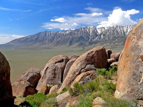 South from the Alabama Hills, Wonoga Peak back left
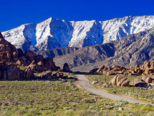 The Horseshoe Meadows Road going south below Wonoga Peak
 Eastern Sierra, Owens Valley and the Inyo Mtns., north from Wonoga Peak