
-
 22414 Hits
-
 80.49% Score
-
 12 Votes
|
|
Area/Range |
|---|---|
|
|
29.17689°N / 13.50786°W |
|
|
Hiking, Scrambling |
|
|
Spring, Summer, Fall, Winter |
|
|
2205 ft / 672 m |
|
|
Overview
 Risco de Famara Risco de Famara |
The northernmost part of the island of Lanzarote is also its oldest part. 16 million years ago the first parts of the island surfaced here and a little later a second island emerged in the south, where today you find the mountain range Los Ajaches. In the north, what remains of these upheavals is a huge cliff: Risco de Famara. The cliff is about 15km long and on the average 550m high. It follows the whole western coast of the northern peninsula of Lanzarote. Several valleys cut through it with the lowest one reaching the cliff at about 350m height. Risco de Famara also is home to Lanzarote's highpoint, Peñas del Chache, located at the southern end of the cliff and reaching 672m.
Both areas, Risco de Famara and Los Ajaches are of volcanic origin - like the rest of Lanzarote. However, you have to look a little more closely to observe the volcanic nature. On Risco de Famara it is most evident by the basalt slabs and pillars which you find in the top 150m. They are made of the red basalt, which is so typical for the Canary islands. Here the cliff is very soliid and the basalt looks as if it could be climbed. Beneath these top 150m, however, "horrible" is the only word to describe the rock quality and I wonder whether the word is strong enough. The cliff base is made up from volcanic ashes which piled up during the eruption of its formative years. In the meantime some of it has baked together in the pretence of solidity. However, rock slides are very common on the cliff, especially since often fierce north-eastern winds crash themselves against it.
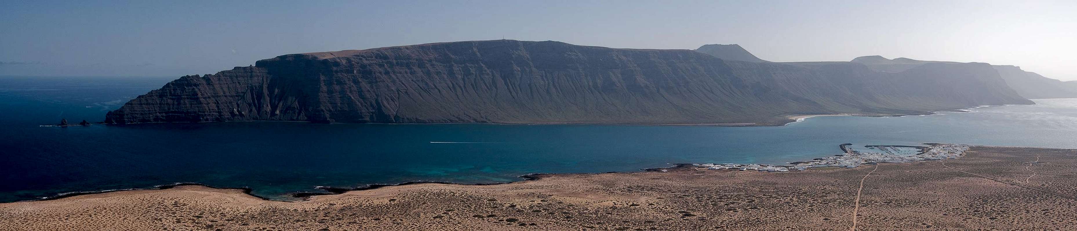  |
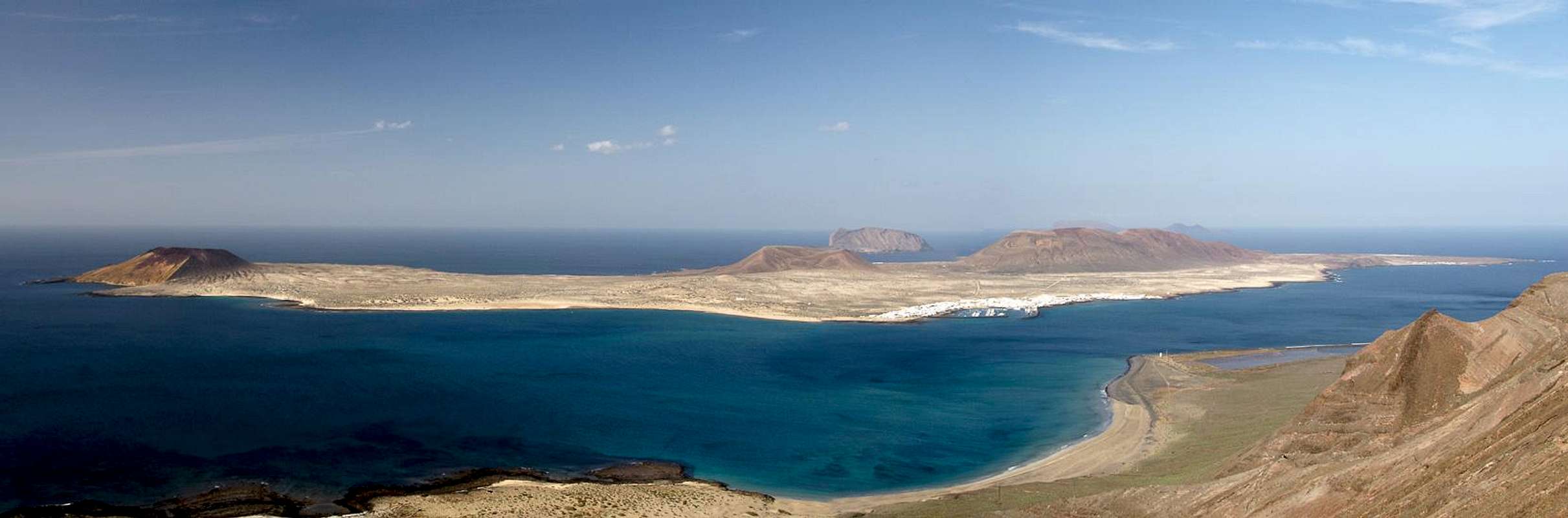
Since it has been protected by a natural park, Risco de Famara is off limits to any activity off the already developed paths and roads. From its eastern side (the back side) it can be reached easily and a handful of Miradores (lookouts) have been created on the brinks of the cliff. The best known one is Mirador del Rio, an old artillery position which Lanzarote's late artist and architect Cesar Manrique turned into a surrealist restaurant. It is one of the "must-see" sites for tourists on Lanzarote so expect to meet crowds there. The other Miradores are more like picknick places, hovering on the brinks of the cliff. All celebrate the unique view of the neighbouring islands of the Archipelago Chinijo in general and the one of its biggest island, La Graciosa, in particular. Risco de Famara is about twice as high as the highest volcanoes on the islands which ensures a great overview over the archipelago.
 |
For most of its length Risco de Famara drops directly into the Atlantic Ocean. But there is an exception in its north-west, where a small plain developed underneath the cliff. Here in the early 20th century a saline, Salinas del Rio, was established to provide the north of Lanzarote with much needed salt. Maintaining the salines proved to be difficult - the shortest path to any village was the climb along a spur of the Risco towards Ye on the plateau on top. This track was soon developed into a mule trail but still turned out to be too demanding on man and animal. Therefore a road was developed, starting at Caleta de Famara in the south of the cliff. It climbed halfway into the cliff, reaching about 300m at a place called Punta de los Roques. From there it descended to the salines. But soon after the construction it became evident that builders hadn't accounted for the Risco's rock quality. Frequent landslides made the road unprofitable so that eventually the Salinas del Rio were abandoned.
 Basalt pillars Basalt pillars |  Top view Top view |  Punta del Roque Punta del Roque |
Today this support road is one of the most spectacular hikes on Lanzarote. It winds along a ledge through Risco de Famara, offering great views and a bit of adventure. In some places rock slides have taken away the ledge altogether leaving you to scramble across very exposed sections of horribly brittle rock. In the last years the road has become almost unnegotiable and you really have to decide for yourself whether you dare to attempt it. In 2015 / 2016 we ourselves decided against it while in 2008 / 2009 it was still possible.
Getting There
 |
Depending on whether you want to hike through the cliff or along its rim there are several possible trailheads:
- Caleta de Famara
Caleta de Famara at the southern base of the cliff is the only trailhead for Ruta del Risco, the abandoned road to the Salinas del Rio.
- From Arrecife take LZ1 to Tahiche
- Switch to LZ10 to Teguise
- Switch to LZ30 west to the Monumento al Campesino
- Take the next turn right (LZ402) to Caleta de Famara.
- Follow the signs for the Urbanisation Famara and drive around.
- Follow the dirt road to an intersection where you park
- Ermita de los Nieves
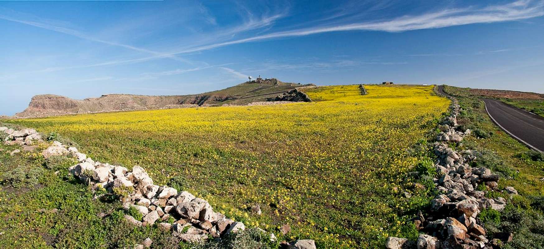
Goood lookout and starting point for a hike around Peñas del Chache, Lanzarote's highpoint
- From Arrecife tale LZ1 / LZ10 to Tahiche and Teguise
- Drive through Los Valles until you reach the irador de Haría
- Turn sharply left onto a narrow side road which leads to Peñas del Chache and Ermita de los Nieves
- Guinate
Lowest and central spot of Risco de Famara, good lookout with a short route On top of a very steep part of the cliff.
- Take LZ1 through Tahiche to Arrieta.
- Switch to LZ10 to Haría.
- Take LZ201 through Maguez until you reach the side road to Guinate.
- Ye and Mirador del Rio
From the hamlet Ye you can hike down to the Salinas del Rio. About 3km north of the hamlet there is Mirador del Rio, one of the most popular tourist attractions of Lanzarote.
- Take LZ1 through Tahiche to Arrieta.
- Take LZ201 north heading towards the crater of Monte Corona
- Pass the volcano on its eastern side until you reach a crossing right at the entrance to Ye.
- Turn right on LZ203 to Mirador del Rio
- For the Salinas del Rio hike stay on LZ201 and drive through the hamlet. A little after you passed the last houses a sharp turn right takes you to LZ202. After 400m to the left there is a cobblestone road, which leads to a small parking lot.
Red Tape
 Pair of Seagulls on Punta del Roque
Risco de Famara is part of the Parque Natural del Archipelago Chinijo, which also includes the five islands to the north of Lanzarote. The natural park was created to protect the many sea birds nesting in the steep cliff. Therefore any activities are restricted to the trails and roads on and through the Risco. Near Guinate a second natural park partly overlaps, the Parque Natural de la Corona.
Accommodation
 Risco de Famara as seen from La Graciosa
Though there are ferries from the Spanish mainland to the Canary Islands, they take more than 24h for the trip. Therefore most visitors therefore go by plane. Every travel agency in Europe offers flights, hotel rooms, apartments, rental cars etc. so that reaching the Canaries is rather a matter of money than opportunity. During the summer season flight fares can be reasonable but during the Easter and Christmas holidays you have to be prepared for additional fees of 500€ per person.
Lanzarote has its own airport between the capital Arrecife and one of the main tourist centres, Puerto del Carmen. There are public bus lines but – like on all the islands – they don't run too regularly. If you plan to stay on your own, better take a rental car right at the airport.
As for holiday homes, hotels or apartments either consult your nearest travel office, or – search for lodgings on Google. There are several sites on the web, dedicated to rent privately owned houses or apartments. Prices are generally a bit less expensive than for tour operators but you don't have as much security.
Weather Conditions
Lanzarote is usually swept by fierce north-western trade winds. Though they deposit their humidity on almost all of the other Canary Islands, Lanzarote is simply too low to form a decent obstacle. Therefore the climate is very arid.For some time of the year, eastern winds prevail, which almost always carry clouds of Sahara dust with them. Usually this means reduced visibility but in some occasions "Calima" occurs. Fierce storms take up the dust from the Sahara and sweep it across the islands. In these times visibility is nil and sometimes even the planes are grounded.
Maps & Books
Maps
Regular Maps
- Lanzarote
Kompass Map WK241
Kompass Verlag
1:50000
ISBN 3-85491-175-0
Digital Maps
Kompass is the only company known to me which offers GPS digital Maps. In addition for those of you with Garmin GPS receivers there is a map source map set of all Canary islands out there.
- Lanzarote
Kompass GPS4241
Kompass Verlag
ISBN 3-85491-223-4
- Islas Canarias
Map Source custom map
By Manfred Pepper
downloadable zip-file
Books
My recommendation is a guidebook by Rother Verlag, available in German. The book is an excellent hiking guide covering all the interesting areas of the island. Since it comes with small maps for each excursion it might even be used without a map to support them.
- Lanzarote
Rolf Goetz
Rother Verlag
ISBN 3-7633-4302-4