
|
|
Mountain/Rock |
|---|---|
|
|
50.18745°N / 17.10777°E |
|
|
Hiking, Mountaineering, Bouldering, Skiing |
|
|
Spring, Summer, Fall, Winter |
|
|
4672 ft / 1424 m |
|
|
Overview
 Keprník in the distance
Keprník, 1424 metres, just 1 less than Králický Sněžnik, is the "third giant" (over 1400) in the Jeseníky, behind the king its famous neighbour Praděd.
(thus despite the definition of the region of the Jeseníky varies between Czech Republic and Poland, where Śnieżnik is generally not considered as a part of it).
Despite its size and importance, Keprník is from far the wildest, less known, and less visited of the trio. However, this is for some (and I think most of SPers :) the best reason to visit it...
 On Keprník
This is perhaps partly because of its unpronounceable name, derived from "Kepernik", occasionally used on old maps and sometimes in Polish language. Unlike Sněžnik and Praděd (as far as I know), Keprník, to who we often forget the accent on the "I", does't have, and never had, a wiew-tower (current of former) on its top, like most famous summits do in the Sudetes. It was named Köpernik Glaser in German (this region was a part of Prussia during around 2 centuries).
Keprník, with its huge superficy, is rather like a desert of harsh vegetation made of robust spruce trees, dwarf pines, peat bogs and few pastures. Local people like to surname it the "Czech toundra", with good reasons.
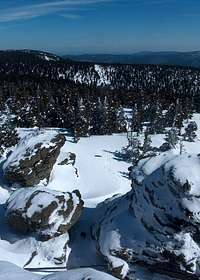 Vozka rocks
 Avalanches at Červená Hora !
This mountain is in fact formed of 4 tops, Keprník being only the highest; most of them are topped with strange and interesting gneiss outcrops, resulting from a complex geological process: Červená Hora (1337), Vozka (1377) and Šerák (1351). Another outcrop, from far the hugest and most interesting, Obrí Skaly, is located below the last.
Červená Hora ("red mountain"), is famous for its source (and probably takes its name after the rusty colour of the waters), and for one of the most important avalanchous slopes in the Jeseníky on its East side.
The Keprník unit belongs in fact to the same range than the Praděd unit, to which it is connected by a pass, Červenohorské Sedlo, on which a famous ski resort is located.
 Chata Jiřího na Šeráku, old postcard
 Červenohorské Sedlo
Most people visit this mountain from here, maging the triangle Červená Hora - Vozka - Keprník.
Some others start from the north side and Šerák, on which the only mountain-refuge is located (Chata Jiřího na Šeráku), near the other ski-resort, Bonera.
Few other people make the whole traverse, assurely a rewarding trip. In winter, this area makes a fine terrain, flat enough, for cross-country skiing.
It could also make a very fine terrain to cycle on its whole length, but due to nature preservation, the trails accessing the top are not open to bikes, only Šerák is (see MBPost trail). But the whole area is strewn with a dense network of well marked cycling trails, often asphalted, narrow and closed to cars. Czech Republic is famous for being a fine country for cyclotouring, and the Jeseníky is one of the best Czech regions for this type of infrastructure.
 Cycling in the Šerák-Keprník area
Along the main hiking trails to the top are placed some informative and very interesting panels about specificities of this ecosystem.
The Keprník-Šerák range did not always look like nowadays. At the beginning of the century, almost the whole summital dome was made of pastures for the needs of grazing sheep, following an intense deforestation. But, the lord of the region, fortunately already aware at this time of the nefast secondary effects, ordered the reforestation of the massif. In order to motivate the actors of this operation, concours were organized amongst foresters: the one who would plant the maximum trees on a defined surface for a lap of time...
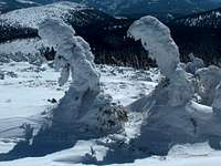 Pines
Pines And pines..
The result turned out to be very successful, but experts nowdays point out that the primeval character of the former forest tends to disappear, as these foresters introduced trees species from lower regions of the mountain, more vulnerable and less adapted to the harsh environement of these wild inhospitable areas. Others underline the big mistake that was the introduction of the Pine Mugo, not originary to this region, which tends to overdevelop, at the detriment of endemic species.
Anyway, nowadays, hiking in the high levels of the Keprník forest is a pleasure, with combined smells of many conifers. and fine wild mountain atmosphere.
On the animal side, the Pine Mugo was not the only one to be introduced: some chamois of the Alps were successfuly released in the 70s, following an experiment, and now form a sustainable population, extending until Sněžnik.
Reading the informative panels, we also learn that these mountains were the former border of Poland, and Keprník was surnamed "Mountain of the Three Kingdoms", being the dividing point between three powerful regions, two of them in Czech Republic (Moravia being one of the 2 if I remember well), and the third the county of Wroclaw, nowadays in Poland.
 Červená Hora
 Obří skály
Back to Červená Hora, below the top, as we pass the little chapel located near the source mentioned above, we learn that for a quite long time, not only a chapel was located here, but also a mountain refuge and a wide "square": Since the water was at the origin of many noticeable miracles, Červená Hora used to be the object of a very big mass pilgrimage every year, sometimes gathering 2000 people ! From this local "Lourdes", none of this remains nowadays, but for many people of the region, the name of Červená Hora is much more familliar to designate this mountain than Keprník.
Map
 Keprník range
Getting There
Depending on where you come from, it may be better to reach the range from the South (basically from Czech Republic), via Šumperk, or from the North (then from Poland), via Jesenik.From both cities the pass Červenohorské Sedlo is accessible (road under maintainance from Jesenik during 2008 and maybe longer, beware). Beware, Červenohorské Sedlo car park is not free and costs some 200 koruns (some 7-8 Euros) the day. Wild parking in such areas in Czech republic can also bring bad surprises (blockers on one wheel and extra walk to the nearest police, probably down in Bělá pod Pradědem...)
To climb Keprník via Šerák from the North, you must reach Jesenik in all cases, the starting point.
Jesenik deserves a visit, it has a historic and beautiful thermal resort located on a little hill, with fine views; this used to be the land of locally famous Vincenz Priessnitz (from which the polish word "prysznic", "shower", comes from). A fine liqueur based with herbs is also made there :)
 Map of the Jeseniky
Red Tape
As mentioned above, this is a protected area:- Offtrails tolerated (as far as I know)
- No wild camping
- No rubbish
- No cycling out of the bike-marked trails
Accomodation
 Chata Jiřího na Šeráku nowadays
 Červenohorské Sedlo in winter
As mentioned above, no wild-camping, but 2 refuges:
- Chata Jiřího na Šeráku onŠerák
- Many accomodations at the pass Červenohorské Sedlo, like Chata H&D, rather hotel standards for skiers.
In the valley, there are hundreds of possible cheap places with correct standard to accomodate, between Jesenik and Bělá pod Pradědem : Guesthouses, Hotels & Pensions...
Many of them have the label "cyclers welcome", which means the kind of standards hikers may also be looking for.
yatsek - Aug 11, 2012 1:10 pm - Voted 9/10
Five thingsGerman name: Probably Köpernik Glaser (See here) Pronunciation: AFAIK The stress isn't on the "i" but this "i" is a long vowel Geology: Not granite but gneiss Access: No info on access from the west (Ramzova, Branna) History: Not sure about Wroclaw Bishopric, but I don't think Poland has ever reached the summit of Keprnik. "The mountain of three kingdoms" seems impossible anyway.
visentin - Aug 21, 2012 8:51 am - Hasn't voted
Re: Five thingsCorrections (at least few) done. I need to rewrite the access, by the way last year I rode it a second time from Ramzova ;) As for the "mountain of three kingdoms", you know Yasek, I'm not a born-Easter-Central-European (despite the map shows I am almost), but my eyes still see well, and I just rewrote what was on the signs of the educational trail on Keprník...
yatsek - Aug 21, 2012 10:21 am - Voted 9/10
Re: Five thingsPerhaps lands/counties, not kingdoms/countries: Silesia, Moravia and Grafschaft Glatz (Ziemia Klodzka)?
visentin - Aug 22, 2012 3:32 am - Hasn't voted
Re: Five thingsI'll tell you when I come back ;)
yatsek - Aug 22, 2012 5:54 pm - Voted 9/10
Re: Five thingsMaybe they mean Bohemia, Moravia and Silesia, but then I guess Snieznik would claim the title. And what about Smrek and the Pass of Three Borders? Well, write it all down when you get there next time.:)