
-
 4415 Hits
-
 83.1% Score
-
 16 Votes
|
|
Mountain/Rock |
|---|---|
|
|
44.81780°N / 109.0538°W |
|
|
Park |
|
|
Hiking, Scrambling |
|
|
Spring, Summer, Fall, Winter |
|
|
5090 ft / 1551 m |
|
|
Overview
 Beartooths
Peak 5090 is the highest mountain in the Badland Hills, which are located in the Badger Basin badlands in northwestern Wyoming. This summit has some great views of the surrounding hills, the vast and wide spaces in the basin, and the eastern edge of the Beartooth Range.
The peaks in this area see very little traffic, and are seldom climbed except by people interested in collecting summits in the Cody area. This is a shame, as Peak 5090 is really a fun mountain to climb that is easily done in less than two hours from the car.
 Peak 5090
Getting There
To reach Peak 5090 from Cody, Wyoming, head towards Powell on Highway 14A for about 13 miles and turn left on Highway 294. From Powell, go towards Cody for about 8.5 miles and turn right. Drive on 294 for 8.4 miles and turn left on Little Sand Coulee Road, which is the unmarked dirt road that crosses over a cattle guard through the fence. This road is in pretty good shape with just a couple of rough spots where water drainage has damaged the road, but there is no need for 4WD. Park on the side of the road after about 4 miles and head west towards the mountain. Class 3 rock section
 On the southwest side
The approach to the base of the peak is three quarters of a mile off-trail across a landscape of sage brush, cactus, yucca plants, and fields of large rocks. The side of the mountain is steep and will require some route-finding, but it is not too difficult; the southwest side is Class 2, while the southeast side has a short stretch of Class 3 climbing through a small band of rocks. The top of Peak 5090 is made up of two plateaus that are connected by a thin ridge. The highest point is on the smaller area at the south end. Climbing Peak 5090 involves a Class 2 or 3 scramble on the mountain with about a mile of one-way travel and 600 feet of elevation gain.
 Summit View towards the Beartooths
Red Tape
There are no fees to hike in Badger Basin. This area is mostly BLM land with a few very small parcels of Wyoming state land scattered throughout. Fences generally separate these areas and run along the highways; cattle graze this land from time to time, so the fences and cattle guards help keep the animals off of the road. Since it is pretty much all federal and state land, hiking is allowed throughout the entire area. Judging by some deep animal tracks and some pretty torn up places on the 4WD roads that branch off of the main dirt roads, this area gets pretty treacherous when it is wet, so exercise caution. It would probably be best to avoid this area during hunting season, so check with the Cody BLM office about dates.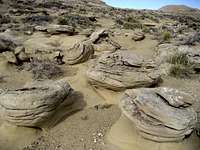 Rock Garden
 Peak 5090
This is prime rattlesnake country with very little in the way of established trails, so every step taken while walking around the basin takes you close to another clump of sage brush that could hide a snake. For this reason, the winter months may be the best time to hike this area, as the snakes will stay in or very close to their dens during the cold season; if you do hike here in the summer, always keep listening and watching!
Camping
Standard BLM regulations for camping apply throughout the basin. There is very little water here, so plan accordingly. For more information, visit the BLM camping rules page at:http://www.blm.gov/pgdata/etc/medialib/blm/wy/information/docs.Par.1775.File.dat/wynf-0019.pdf
External Links
Information on the Badland Hills Quadrangle:Badland Hills
What to do in case of a Rattlesnake bite:
http://www.whmentors.org/saf/snakes.html