
|
|
Mountain/Rock |
|---|---|
|
|
47.68090°N / 121.42454°W |
|
|
King |
|
|
Hiking, Mountaineering |
|
|
Spring, Summer, Fall, Winter |
|
|
5280 ft / 1609 m |
|
|
Overview
Standard routes that involve miles of road hiking and limited viewpoints for much of the route due to thick forests. That might not sound like a decent peakbagging experience at first glance, but Cleveland Mountain might surprise its visitors. Located near Skykomish, Washington, Cleveland Mountain is a peak overlooking nearby Money Creek Campground and Miller River Campground, and located within the upper boundary of the regionally popular Alpine Lakes Wilderness. The peak is also #78 on the "Home Court Top 100" peakbagging list. Cleveland Mountain
Cleveland Mountain was named in honor of the former United States President Grover Cleveland. Many years ago, there was a town named Berlin near the mountain, in what is now northeastern King County. The town postmaster proclaimed, "Our most conspicuous and highest mountain, named when (Grover) Cleveland was elected, would have been named for his opponent (Benjamin Harrison) if he had been successful." SOURCE: Washington Historical Quarterly, July 1920
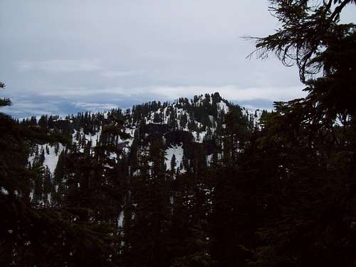 Looking South At Cleveland Mountain Summit
As is the case for most of the peaks within the Alpine Lakes Wilderness, Cleveland Mountain has at least one alpine lake in its vicinity. Cleveland Lake, a tiny lake at approximately 4000’ elevation, is located NNE below the summit. Due to being surrounded by tall evergreen trees and ridges, the lakewater tends to remain cold throughout the year and is quite commonly snow-covered from late Autumn through mid-to-late Summer. The lake is an easy side-trip from the standard approaches of Cleveland Mountain.
 Cleveland Mountain Above Cleveland Lake
The standard summit approaches involve a combination of on-road and off-road travel. Off-road travel mostly involves thick evergreen forests and ridge ascents. The thick treecover (including some old-growth and second-growth), found on many of the mountain slopes, begin to dissipate at the higher elevations. The summit is basically a rocky hill with a 360-degree panoramic view, which helps make the effort of reaching the summit feel more worthwhile. Historically, the summit had a fire lookout camp setup on it starting in 1918, but by 1924 that camp was abandoned. A USGS Benchmark disk is located atop the summit rocks.
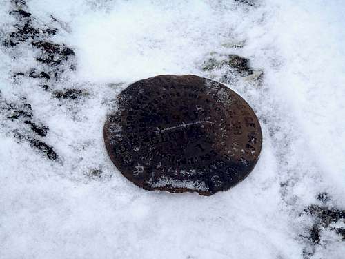 Summit USGS Benchmark
The upper slopes of Cleveland Mountain have potentially dangerous avalanche slopes. Summit attempts should only be attempted when avalanche danger is rated as low or low-to-moderate for the area. Another consideration during periods of snowpack are moats, as the large quantity of trees, boulders, and cliffs on the mountain has the potential for accidents due to tree-moats, rock-moats, and cliff-moats.
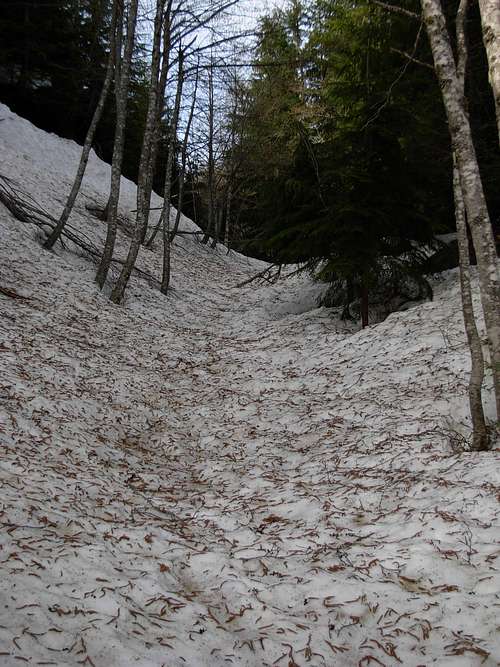 Snowshoe-Friendly Snow-Covered Road...
Getting There
1) Follow Highway 2 to approximately MilePost-46, and turn SE onto the Old Cascade Highway. NOTE: This is the Money Creek Campground turnoff from Highway 2.2) Follow the Old Cascade Highway for exactly one mile. Turn right (south) onto NE Miller River Road.
3) Within one block, turn right (west) onto Money Creek Road, also known as Forest Service Road #6420.
4) Drive approximately 0.7 miles to a bridge crossing Money Creek. The old logging road (FS-6422) leading to Cleveland Mountain begins on the left (south) side of FS-6420.
5) There is a turnout/turnaround area at the entrance to FS-6422. Park at that area (~900' elevation), just off the main road. Begin hiking up FS-6422.
NOTE: Some people opt to briefly drive up FS-6422, as most automobiles might be able to reach a small turnaround spot at 1070' elevation, approximately 0.3 miles up from Money Creek Road. However, FS-6422 is narrow, rocky, and has few turnaround/parking spots, and is generally not recommended to attempt driving up. High-clearance four-wheel drive vehicles might be able to reach the first road switch approximately 1.0 miles from Money Creek Road, but again there are few turnaround/parking spots (and larger vehicles require more space).
Standard Summit Approaches
The original standard summit approach follows FS-6422 as it switchbacks up forested slopes northwest of the mountain, and then becomes basically a ridge-hike from one of several upper road-ends. This is typically used as a Summer approach and as way to gain more distance/exercise, although following the road system tends to be easier for snowshoeing than bypassing the road (see next paragraph). Standard & Road-Bypass Route Options
A variation of the standard approach is to bypass most of the road system by heading more directly uphill. This "Road-Bypass" route option allows for less overall distance and time than following the road system, but with quicker elevation gain. Once at one of several road-ends above 3400' elevation, several possibilities exist to reach the ridgetops above. The "Road-Bypass" route option is best recommended during Winter/Spring, if snowpack is fairly consolidated and when avalanche danger is either low or low-to-moderate.
Please review the following general route map, for further details:
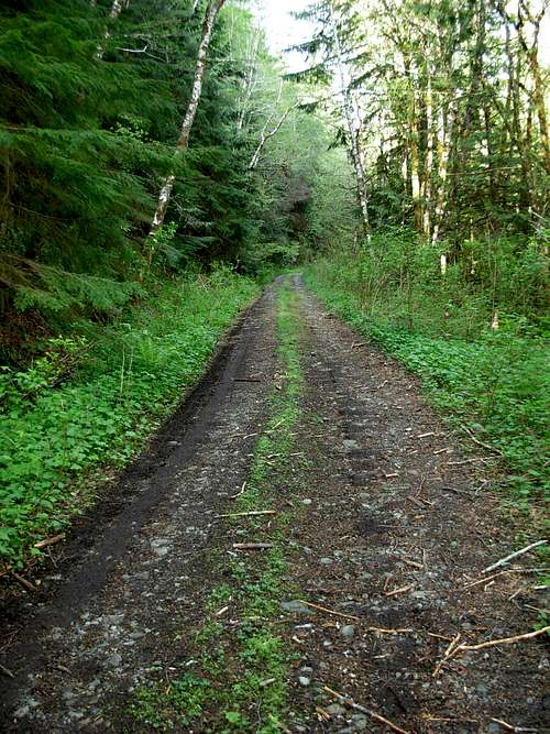 Following Temple Mountain Road (FS-6422)
STANDARD APPROACH (Road System):
An old logging road (FS-6422, a.k.a. Temple Mountain Road) switchbacks up northwest of the mountain, comprising most of the hiking distance. However, the road is not recommended for vehicular usage due to rough sections, one-lane, and very limited turnout/turnaround spots... and even four-wheel drive vehicles will not continue past the first mile or so of the logging road (at approximately first switchback near seasonal stream). Multiple sections of the road have been either washed-out by streams and mudslides, or pass across seasonal streams. There are many downed branches and trees across sections of the road, as well. The lack of vehicle usage on the road might help make the first stage of the summit route feel more like a wide trail than a road.
 Following Forested Ridge...
Continue following FS-6422 as it switchbacks through thick evergreen forests, until the northern summit ridge of Cleveland Mountain is reached at a southbound-facing switchback (~3300' elevation). An alternative is to continue following the old logging road until its end (~3800' elevation) before steeply attaining the ridgetop, but that adds more hiking distance. Basically, the key is to attain the forested ridgetop connecting Temple Mountain (located to the north) and Cleveland Mountain (located to the south).
 Looking Up North End Of Knife-Edge Ridge...
While hiking south along the thick evergreen-forested northern ridgetop of Cleveland Mountain, a knife-edge rocky section (~4400 elevation) is encountered. This knife-edge section involves some YDS Class 2 & Class 3 scrambling, and is only recommended to cross directly during periods of dry, non-icy, non-snowy conditions (such as late Summer/early Autumn). During periods of icy and/or snowy conditions, it is recommended to bypass the rocky knife-edge section by heading downhill before the knife-edge section and side-traverse steep forested slopes. The western slopes are appear to be a better option, due to being less steep than slopes below the eastern side of the knife-edge section. Some people might even opt to skip this section altogether by heading downhill to Cleveland Lake and then steeply ascend slopes toward the summit, although that would require more time and effort.
 Cleveland Mountain Summit
After the knife-edge section has been crossed or bypassed, hike slightly downhill and southeast into a large basin located immediately northwest of the upper mountain slopes. Cross across or around the basin, then side-traversing along slopes until north of the summit. Then ascend south up the summit ridge, encountering or bypassing a couple of brief steep slopes, until reaching the rocky summit.
 One Of Multiple Seasonal Stream Crossings Along Road
------------
The standard summit approach has two main road options (although more might be possible):
STANDARD APPROACH ROAD OPTION #1:
Hike up the old logging road (FS-6422) for approximately 3.7 miles, to a southbound-turning switchback (~3300' elevation). From the switchback, hike off-road slightly southwest, south, and then southeast along the thick evergreen-forested ridges (as described above) for approximately 1.5 miles to the open summit (5280' elevation). This option has an gentler-sloped initial ascent from when leaving the old logging road and has less overall hiking distance, but requires more off-road hiking through thick forest.
TOTAL ESTIMATED ROUNDTRIP HIKING DISTANCE: 10.4-11.0 miles
 At North-Facing Viewpoint
STANDARD APPROACH ROAD OPTION #2:
Hike up the old logging road (FS-6422) for approximately 4.5 miles, to its end at a north-facing viewpoint (~3800' elevation). NOTE: Prior to the last switchback, the old logging road encounters a "T" intersection (~3500' elevation); head left (east) at this intersection, not right (west). From the end of FS-6422, steeply ascend the mountain slopes southeast until the top of the forested northern ridgeline of the mountain is reached. Then hike slightly southwest, south, and then southeast along the thick evergreen-forested northern ridgeline of Cleveland Mountain to the open summit (5280' elevation). From the end of FS-6422 to the summit is approximately 1.2 miles hiking distance.
TOTAL ESTIMATED ROUNDTRIP HIKING DISTANCE: 11.4-12.0 miles
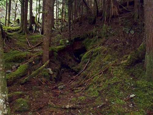 Old Mine
The standard summit approaches range from 5.2-6.0 miles, each way, with nearly 4400' elevation gain from Money Creek Road to the summit.
------------
ROAD-BYPASS APPROACH:
The "Road-Bypass" route option follows FS-6422 to the first road switchback, located at a seasonal stream approximately 1.0 miles from Money Creek Road. Rather than continuing (switchbacking) on the road, cross straight over the seasonal stream and join an abandoned flat road on the other (east) side of the seasonal stream.
Follow the flat road briefly, until finding a preferable location to begin ascending off-road and southerly up sometimes steep forested slopes. The seasonal stream will *always* be to the climbers' left (east) side, for the "Road-Bypass" route. Continue ascending fairly easy yet steep forested slopes, passing across FS-6422 on multiple occasions.
NOTE: An old abandoned mine might be encountered a short distance above the flat road. Some old rusted mining remnants might be found near the mine entrance. It is not recommended to enter the mine.
 Crossing Open Area Below Knife-Edge Cliffs...
Once the road is reached at or near 3400' elevation, begin following the road SSW to the "T" road intersection mentioned in the "Standard Approach Road Option #1" mentioned earlier. However, rather than heading left (east), as what was recommended for that option, turn right (west) and follow the road continually uphill until reaching a road-crest, at approximately 3800' elevation and nearly west of the knife-edge ridge section. Begin hiking off-road and steeply uphill, angling and side-traversing southeast until the rocky western cliffs of the knife-edge ridge can be seen looming above. Pass below the cliffs in an open/treeless area, and steeply ascend up to a tiny saddle immediately right (south) of the cliffs. Briefly follow the narrow ridgetop southward before slightly descending southeast toward a basin (see map).
 At Tiny Saddle Immediately South Of Knife-Edge Section...
 Final Summit Slope
Cross across or around the basin, then side-traversing along slopes until north of the summit. Then ascend south up the summit ridge, encountering or bypassing a couple of brief steep slopes, until reaching the rocky summit. Use extra caution on the upper slopes of Cleveland Mountain, due to potential moats, avalanches, and steep slopes.
 Cleveland Mountain Summit
 A Snowed-Over Cleveland Lake
Red Tape
Because no official U.S. Forest Service trailhead exists for Cleveland Mountain, no Northwest Forest Pass (i.e. parking pass) is required. However, due to the usage of Forest Service roads to reach the parking area, a Northwest Forest Pass is definitely advised so vehicles do not appear to be abandoned.Make certain to have no valuables visible in any vehicles, in case of car prowlers.
Camping
Cleveland Mountain is located in the Alpine Lakes Wilderness, so backcountry camping is allowed.However, camping is prohibited on and along the old logging road (FS-6422) that switchbacks up to the saddle between Cleveland Mountain and Temple Mountain.
Also, no camping is allowed within 1/4-mile of Cleveland Lake, located on the upper slopes of the peak at ~4000' elevation.
 Enjoying Much Snowpack At Lake
[img:623956:aligncenter:medium:Enjoying Much Snowpack At Lake]