
|
|
Mountain/Rock |
|---|---|
|
|
51.60960°N / 4.98108°W |
|
|
Pembrokeshire |
|
|
Trad Climbing |
|
|
Spring, Summer, Fall, Winter |
|
|
131 ft / 40 m |
|
|
Overview
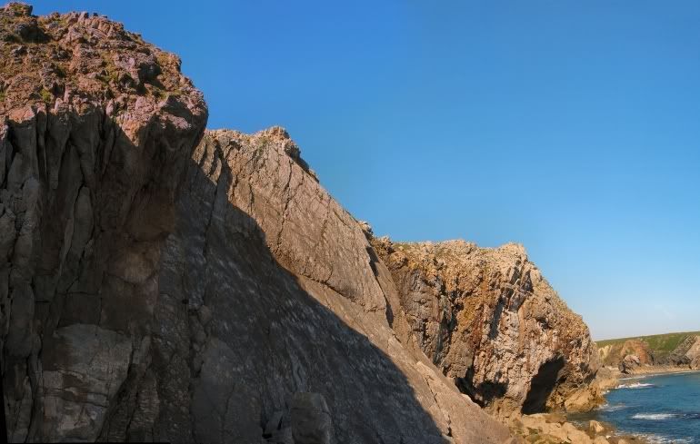
The headlands of the Castlemartin Range are home to some truly world class climbing, and the headland that separates the golden beaches of Flimstone and Bullslaughter Bays is no exception. It’s obviously identifiable from a large rock arch, known as Moody Nose, which sits uncomfortably upon a landward slanting slab on the headland's most southerly tip. |
Rock Climbing
The climbing at Crystal Slabs can be split between five areas: Levitation Wall, The Crystal Block, Crystal Slabs, Mosaic Wall and Thunder Wall. With the exception of Levitation Wall and the Crystal Slabs themselves, all areas are in some way affected by the tide, the degree of which can depend of the time of year and weather. All of the crags can be reached by scrambling down rocks to a grassy ramp on the eastern side of the large rock arch. Descend the ramp eastwards to the base of the slabs, which also gives access to the area’s other crags. |
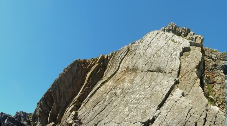
Crystal Slabs (Photo by Nanuls)
Crags and routes are listed from left to right, and are graded and rated with the aid of the old Climbers' Club Guide to Pembroke, the old Pembroke Supplement and the 2009 Rockfax Pembroke guide. Since then, the Climbers' Club have published a new comprehensive guide for this area, Pembroke Volume 3: Range East – Stack Rocks to Hollow Caves Bay, which adds a significant number of new crags and routes to the area, though the changes to this pages' crags are few. Nevertheless it is recommended that you refer to this or the Rockfax book for up-to-date information and route descriptions. In addition to these sources Rockfax’s website also has descriptions for the routes included in its book, which can be viewed on its online route Database. Routes are rated using the British Adjectival Grading System. A conversion table of international climbing grades by SP member Corax is available: download it here. With the exception of Tenby South Beach Quarry, bolting is strictly prohibited everywhere in Pembroke, so don’t even think about it here. Route Symbols:
Levitation WallThis is the steep wall around 50 metres west of the main slab, and is the first crag reached on the approach. At its right end is a big corner leading to an overhanging cracked wall, Overhead Cam and Crankshaft start up this corner. |
| No. | Name | Length | Pitches | Adjectival Grade | Technical Grade | Quality | Restrictions |
|---|---|---|---|---|---|---|---|
| 1. | Captain Cat and the Fish-Head Nibblers | 17m | 1 | HD |  | | |
| 2. | Pump up the Volume | 18m | 1 | E3 | 5c | | |
| 3. | Levitation | 20m | 1 | HVS | 5a/b | | |
| 4. | Packed Lunch | 18m | 1 | E1 | 5b | | |
| 5. | Overhand Cam | 18m | 1 | E1 | 5b | | |
| 6. | Crankshaft | 18m | 1 | E2 | 5b |  | |
| No. | Name | Length | Pitches | Adjectival Grade | Technical Grade | Quality | Restrictions |
|---|---|---|---|---|---|---|---|
| 7. | Crystal Block Arête | 15m | 1 | VD | | | |
| 8. | Plane Polars | 17m | 1 | HS | | | |
| 9. | Hornblende Buttress | 17m | 1 | HVS | 5a | | |
| 10. | Hornblende Chimney | 17m | 1 | HS | 4b | | |
| 11. | Crossed Polars | 15m | 1 | HS | 4b | | |
| 12. | Thin Section | 15m | 1 | E1/2 | 5b | | |
| 13. | Crystal Block Chimney | 15m | 1 | VD | | | |
| 14. | Powder Finger | 15m | 1 | HVS | 5a | | |
| 15. | Midas Shadow | 17m | 1 | E1 | 5b | | |
| 16. | Line of Cleavage | 15m | 1 | E1 | 5b | | |
| 17. | All the Glitters | 15m | 1 | E3 | 5c/6a | | |
| 18. | Isn't Gold | 15m | 1 | E2 | 5b/c | | |
| 19. | Crystal Facet | 15m | 1 | S | 4b | | |
| 20. | Crystal Facet Arête | 15m | 1 | HVS | 5b | | |


| No. | Name | Length | Pitches | Adjectival Grade | Technical Grade | Quality | Restrictions |
|---|---|---|---|---|---|---|---|
| 21. | Bloodstone | 40m | 1 | VS | 4b | | |
| 22. | Sloose | 30m | 1 | HVS | 4c | | |
| 23. | The Gadfly | 43m | 1 | VS | 4c |  | |
| 24. | Sixth Crack | 46m | 1 | VS | 4c | | |
| 25. | Razzle Dazzle | 46m | 1 | VS | 4c | | |
| 26. | The Crucifix | 49m | 1 | VS | 4c | | |
| 27. | Michelangelo | 46m | 1 | VS | 4c | | |
| 28. | Crystal Edge | 18m | 1 | HVS | 5a | | |
| 29. | 59th Street | 61m | 3 | VS | 4b, 4a | | |
| 30. | Crystal Arête | 46m | 2 | VS | 4c | | |
| No. | Name | Length | Pitches | Adjectival Grade | Technical Grade | Quality | Restrictions |
|---|---|---|---|---|---|---|---|
| 31. | Hole in the Wall | 34m | 2 | HVS | 4c, 5a | | |
| 32. | Paint by Numbers | 43m | 2 | E4 | 6a, 6b | | |
| 33. | Mural Landscape | 46m | 2 | E3 | 5c, 5b | | |
| 34. | Rollerwall | 46m | 2 | E3 | 5c, 5b | | |
| 35. | Public Anenome | 43m | 1 | E5 | 6b | | |
| 36. | Bristol Cream | 43m | 1 | E6 | 6b |  | |
| 37. | Wallbanger | 43m | 2 | E3 | 5c, 5c | | |
| 38. | Digital Tapestry | 46m | 1 | E3 | 5c | | |
| 39. | The Rude Roof | 24m | 1 | E6 | 6b | | |
| 40. | Rude Route | 49m | 2 | E6 | 6b, 5a | | |
Crystal Slabs, Mosaic Wall and Thunder Wall (Photo by Nanuls)
| No. | Name | Length | Pitches | Adjectival Grade | Technical Grade | Quality | Restrictions |
|---|---|---|---|---|---|---|---|
| 41. | Concrete Jungle | 67m | 2 | E2 | 5a, 5b | | |
| 42. | Thunderdome | 53m | 2 | E3 | 5a, 5c | | |
| 43. | Thunderbird | 67m | 3 | E2 | 5a, 5a, 5c | | |
| 44. | Line of Loosed Resistance | 61m | 2 | E4 | 5c, 5c | | |
Weather Conditions and Tides
Weather ForecastThis section displays the weather forecast for Bosherston, which is located just to the east of Crystal Slabs. This gives a pretty good indication of what the weather will be like on the crag, as both Bosherston and the Crystal Slabs area sit at around sea level. This weather forecast is generated by the Met Office Weather Widget Tide TimesTide times can have a significant impact on where and when one climbs. It is therefore extremely important to check the timetables before embarking on trip to the area. UK tides information for all standard and secondary ports is provided by the UK Hydrographic Office (UKHO), and displayed on the BBC's website. The link below provides a link to the nearest monitoring station to Crystal Slabs: |

When to Climb and Essential Gear
| The most reliable conditions are in the summer, but the low altitude of the crag may make it a viable option in winter. The gear needed depends entirely on the routes you plan to do. Easier routes will only require a moderate rack, while harder routes will require a something more comprehensive; a good compliment of friends or other camming devices will certainly help. A single 50 metre rope should serve well on most easy routes, however, double ropes would be a wise choice for the harder stuff. In addition to your usual gear, you might want to bring along an abseil rope to speed up access to the base of the crag. | 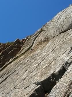 Crystal Slabs (Photo by Nanuls) |
Getting There
When approaching from Carmarthen (SN 405 196) take the A40 Truck Road signposted for Saint Clears (SN 274 160). At the Saint Clears roundabout, take the A477 Trunk Road towards Pembroke Dock (SM 969 036). Before reaching Pembroke Dock, turn left onto the A4075 (SN 019 027) to Pembroke (SM 989 012). In Pembroke, drive straight over the first small roundabout you reach and drive along the A4139 a few hundred metres and turn left and take the B4319 south towards Castlemartin (SR 915 983). Around 500m after the Merrion Camp (SR 939 968), take a left hand turn at a crossroads (SR 931 970) and drive down an unclassified road to the Stack Rocks Car Park (SR 925 946). Park at the Stack Rocks Car Park and walk west along the coastal path, past Elegug Stacks, The Cauldron, and Flimstone Bay. Crystal Slabs (SR 935 943) are located on the headland, which on the Ordnance Survey map is called Moody Nose, just beyond Flimstone Bay, and the descent can be made by scrambling down its western end. The headland is easily identifiable by a large rock arch which sits on a landward slanting slab; the descent is to the east of this arch. If you find yourself reaching Bullslaughter Bay (SR 940 942), you have gone too far. |
Red Tape and Access
| Crystal Slabs is located in the Range East portion of the Castlemartin Range. This area is an Army firing range, although they do not use exploding ammunition. Access is permitted whenever firing is not taking place, which is normally on weekends, Bank Holidays, and in the evenings (after 4.30). The night firing normally occurs on alternate Mon/Wed and Tues/Thurs nights. The Range is sometimes open during the week, but it is best to check before travelling. Phone the 24 hour help line on (01646) 662367. For further information, the British Mountaineering Council (BMC) runs a Regional Access Database, which holds mountain/crag specific information on matters of conservation and access, including issues such as nesting restrictions, nature designations and preferred parking: If you are in any doubt about any particular access arrangement, or need to report an incident, you should contact your local BMC Access Representative or the BMC Access Officers for Wales: Elfyn Jones |  A warning sign (Photo by Nanuls) A warning sign (Photo by Nanuls) |
Camping and Accommodation
There’s an almost unlimited supply of accommodation within the Pembrokeshire Coast National Park so it would be inappropriate to list it all here. For budget accommodation it’s worth checking out some of the following sites: Youth Hostel Association in Wales Independent Hostel Guide Campsites in Pembrokeshire For everything else and more see Visit Pembrokeshire’s website. |
Maps
|
| Navigation Maps Ordnance Survey 1:25k Explorer Series OL 36 South Pembrokeshire/De Sir Benfro Ordnance Survey 1:50k Landranger Series 158 Tenby & Pembroke / Dinbych-y-pysgod & Penfro Road Maps |
Guidebooks
|


External Links
 Mosaic and Thunder Wall (Photo by Nanuls) Mosaic and Thunder Wall (Photo by Nanuls)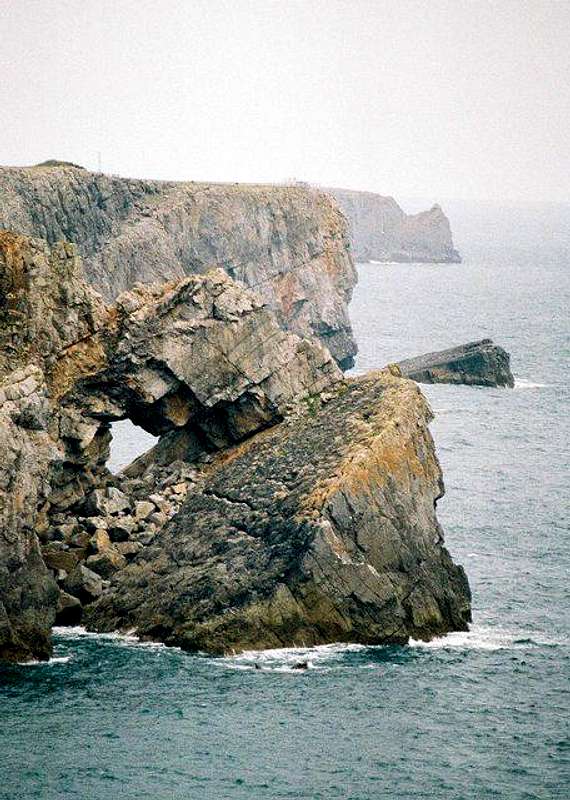 Moody Nose (© Copyright Chris Downer and licensed for reuse under this Creative Commons Licence) Moody Nose (© Copyright Chris Downer and licensed for reuse under this Creative Commons Licence)Government Bodies and Other Organisations Pembrokeshire Coast National Park Authority Association of National Park Authorities Royal Commission on Ancient & Historical Monuments in Wales Maritime and Coastguard Agency Outdoor Organisations and Companies British Mountaineering Council Pembrokeshire Outdoor Charter Group Weather and Tides Tourist Information Travel Information Welsh Public Transport Information Accommodation Youth Hostel Association in Wales Maps and Guidebooks
Cordee Travel and Adventure Sports Bookshop Wildlife and Conservation Joint Nature Conservation Committee Royal Society for the Protection of Birds |