
|
|
Mountain/Rock |
|---|---|
|
|
9.47074°S / 77.41516°W |
|
|
Mountaineering |
|
|
18022 ft / 5493 m |
|
|
Overview
Nevado Churup is a 5,493m peak in Peru's Cordillera Blanca. It is situated at the head of ridge dividing the Quilcayhuanca and Cojup valleys, with the southwest face standing proudly above Laguna Churup. The face is visible from the town of Huaraz, the main base for climbing in the region.Sitting at 4,450m, Laguna Churup is a popular destination for climbers and trekkers who are looking to acclimate. During the climbing season, you will see many people enjoying the views from the rocks surrounding the lakes. If you're a bit more adventurous, you can go for a swim in the glacial lake.
 Churup from Huaraz. Churup from Huaraz. |  Nevado Churup. Nevado Churup. |
Getting There
Huaraz, the capitol of Ancash Province, is the place where nearly all climbers and trekkers stay when visiting the Cordillera Blanca. A full range of services are available. Most any food can be found, but specialty items like energy bars should be brought from elsewhere. Gear can be purchased new or second hand, but don't expect any bargains. All types of fuel are readily available.Huaraz is accessible by plane or bus. Flights from Lima land at a small airstrip about a 20 minute drive north of the center of town. LC Busre operates these flights, which run just over $100 one way. Be aware that luggage restrictions may be prohibitive if you have lots of bags.
The two most popular bus services are Cruz del Sur and Movil Tours. The bus from Lima takes about 8 hours and costs about $25. The seats on these buses are quite comfortable and it is reasonable to expect to get some sleep if taking the night bus. First class seats are available for a few dollars extra and offer more space and comfortable leather chairs.
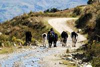
Churup (Southwest face) is easily accessible from Huaraz, with the length of the trip dependent on how far you want to take motorized transportation. The official trailhead is at Pitec, which is essentially a sign post on a dirt road. Pitec is 15.5 km and almost 1000m of elevation gain from Huaraz. If you don't want to walk, a taxi from Huaraz takes about 1-1.5 hours and costs approximately 60 soles. A cheaper alternative is to take a collectivo to the town of Llupa (approximately 4 soles per person, one way), then walk about 7 km to Pitec on a well established trail through high Andean farmland.
From Pitec, a well-traveled trail heads 3.5 km up to Laguna Churup. This trail is moderately strenuous, with the last section involving scrambling up rock bands beside the waterfall that flows from the lake. The lake can be reached in 1-3 hours. To gain access to the face, you must scramble along the slabs and hillside along the west side of the lake (to the left as you approach the lake from the trail). In daylight, this trail is fairly straightforward, rising above the lake and heading through a small forest of quenua trees before reaching the moraine on the far side of the lake. If covered by snow or on a dark night, this unmarked trail can be more difficult to follow. Once around the lake, climb the slope of the moraine, following intersecting paths and occasional cairns. This will bring you to the south end of another small lake. Scramble through the boulders to reach a sandy camping area at the north end of the lake. This camping area is about 1-2 hours from the south end of the main lake.
Other faces of Churup can be reached from Quebrada Quilcayhuanca.
 The Road to Pitec The Road to Pitec | 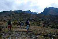 Leaving the Pitec Trailhead Leaving the Pitec Trailhead |  Approaching Nevado Churup Approaching Nevado Churup | 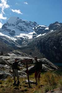 Laguna Churup Laguna Churup |  A beautiful campsite A beautiful campsite |
Red Tape
You must purchase a park pass for Huascaran National Park. These can be purchased at the park office in Huaraz, or directly from an officer who will likely be at the Pitec trailhead. Day passes or 30 day passes (65 soles) are available.Access regulations have undergone almost continual changes in recent years. Currently, the UIAA has secured access for members of any UIAA climbing clum (e.g. AAC, BMC, etc.). You must provide an club ID card when purchasing the pass and it may be helpful to have if you meet a park officer checking passes. If you are not a member of a climbing club, the regulations state that you must have an authorized guide. The level of enforcement and questioning will vary based on the officer you meet. Be prepared and carry appropriate documentation.
Camping
A grassy camping area is available at the Pitec trailhead. Be aware that this is a well trafficked area with many taxis and minibuses stopping to drop off dayhikers.Wonderful campsite are available at the north end of the second small lake that you circumnavigate on the way to the southwest face. The glacier is a 1-2 hour scramble from this campsite.
 Southwest Face Route
Routes

The southwest face is the route most commonly climbed. From camp on the north shore of the small lake below the face, scramble through boulders, following cairns up the valley and eventually up the left side of the valley to the lowest point of the glacier. You will follow the small stream that flows from the glacier/snowfield. Climb up the straight forward glacier before traversing right under a large rock buttress to a moderate (50 degree) slope that ascends up and left for about 200m. Here you will encounter several crevasses, but all are easily crossed.
Eventually, a large rock band will necessitate a rightward/upward traverse on steeper snow/ice/rock. Ascend to a belay below the large rock buttress that extends all the way to the summit ridge. From this belay, 20 m of steep (85 degree) mixed climbing extends through the rock band at the bottom of the main face. Once past, more moderate climbing leads to the summit ridge.
Conditions on the face can vary greatly. Early in the climbing season (June), deep powder snow may make ascending the lower glacier more challenging. Conditions on the upper face vary from perfect neve, to alpine ice, to sugary powder snow, to exposed rock sections. In recent years (2009, 2010), reports have suggested the face is becoming more and more rocky. Always check with the Casa di Guias for current information, or just pull out binoculars and check it out from Huaraz.
Rappel anchors existing on the rock buttress at the edge of the face. These anchors range from pitons to nuts to slings. As always, be sure to inspect the gear before you use it, replacing what may have deteriorated. These stations are spaced at about 50 m. These stations can also be used on the ascent, but easier climbing is typically found further out in the central area of the face.
 |  |  |  | [img:568463:aligncenter:small:] |
Other Routes
The north face of the mountain is purely a rock face. The south face, rock and snow/ice, has also been climbed (See Sharman guidebook).
Additional Information
The sourthwest face route is described in Brad Johnson's "Classic Climbs of the Cordillera Blanca" (P 182).The Casa Di Guias in Huaraz may have information on the current climbing conditions.