
|
|
Mountain/Rock |
|---|---|
|
|
44.60559°N / 114.46531°W |
|
|
Custer/Lemhi |
|
|
Hiking, Scrambling |
|
|
Summer, Fall |
|
|
10196 ft / 3108 m |
|
|
Overview
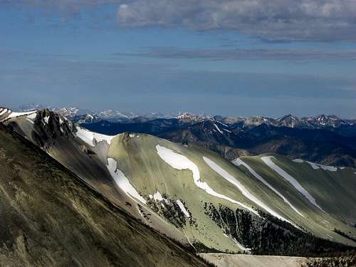
North Twin at 10,196 ft., is the 5th highest peak in the Salmon River Mountains of Idaho. Together with its southern neighbors, South Twin and White Mountain, this peak occupies some of the highest territory in the entire range. South Twin is the second highest peak in the range and White Mountain is the highest point in the Salmon River Mountains. This mountain is an easy class 2 hike from Twin Peaks pass. North Twin
Depending on where you’re looking from, North Twin will take on a different shape. From the North and South it looks like a long rocky ridge with three points. From the East and West it appears to be a narrow, pointy cone. When viewed from Challis, Idaho the Twin Peaks stand out obviously above everything else to the Northwest of the town.
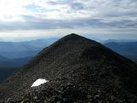 True Summit
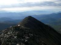 South Summit
The peak is administered by the Salmon-Challis National Forest.
Getting There
From Challis take highway 93 East (towards Salmon) and turn left on Clinic Road. This will intersect with Challis Creek Road after curving around the town’s medical clinic and assisted living center. Turn Right on Challis Creek Road which will eventually enter the Challis National Forest and turn to dirt. This road will split and the left fork will take you to the Challis Creek Lakes. The right fork will be labeled as Sleeping Deer Road and will take you up Bear Creek Canyon towards the pass between North and South Twin. Beyond the pass the road will continue for 24 miles into the heart of the Frank Church Wilderness, eventually ending near Sleeping Deer Mountain. Continue up Sleeping Deer road and eventually you will come to some houses. Just before the houses the road enters a pasture where a herd of horses and pack mules are kept. They like to stand on the road so you’ll probably need to coax them out of the way. At the edge of the pasture the road is gated to keep the animals in. Open and pass through the gate and remember to close it as soon as you’re through. Just beyond this the road splits again. Stay on Sleeping Deer Road which at this point has become a narrow two-track road. The farther up the road you go the better it will get though. Here it begins to parallel Bear Creek as it heads towards the 9,183 ft Twin Peaks Pass. Just before you get to the pass there will be some abandoned cabins where the road will split again. The left fork it the one that least to the lookout atop South Twin. The right fork will continue up to the pass where the North ridge of South Twin meets the South ridge of North Twin. Wonderful Sunset
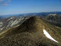
The pass forms part of the border between Custer and Lemhi Counties and it also serves as the boundary to the Frank Church Wilderness. At the pass there is a great camping site with a primitive toilet. Just above the camp the bare slopes of North Twin are visible. This is the best place to climb the peak. It is about 1 mile away and 1,000 ft. up over moderate terrain with no real obstacles. When you get near the top it will first appear to have two summits. Aim for the one on the right as it is the highest. Soon it will be apparent that there are actually three summits. The center one is the highest and since that is the one you were aiming for when you saw it on the right you should just keep going to the top of it. The descent is as easy as the ascent and there are some parts you could almost glissade down the loose dirt and scree.

Red Tape
 North Summit
Also, as with all wilderness areas, motorized travel is restricted in the Frank Church Wilderness. You shouldn’t need to worry about that though since you’re coming to climb.:) Remember, pack it in, pack it out.
No permits of any kind are required.
Weather

Camping
There are several good camping spots along Bear Creek and there is one established site with a table and fire ring near the cabins where the road splits. The best place, though, is the camping area on the ridge at Twin Peaks Pass. It gives direct access to the South Ridge of North Twin and has a toilet (with only two walls and no roof).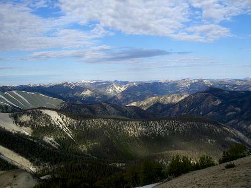 Western View
External Links
Salmon-Challis National ForestThe Idaho Outdoors Forum is where you can talk to others interested in Idaho's mountains.
This is the website for Tom Lopez'sIdaho: A Climbing Guide, the premier guide to Idaho's mountains.
Some info about the Frank Church-River of No Return Wilderness
 White Mountain