
-
 13868 Hits
-
 84.27% Score
-
 18 Votes
|
|
Mountain/Rock |
|---|---|
|
|
44.40880°N / 109.7286°W |
|
|
Park |
|
|
Hiking |
|
|
Summer, Fall |
|
|
10219 ft / 3115 m |
|
|
Overview
 Clayton Mountain
Clayton Mountain is located along the northern border of the Southwest Absaroka Range near Yellowstone Park in Wyoming. It is only briefly visible in one or two spots from the North Fork highway, which runs between the town of Cody to Yellowstone, as smaller ridges that descend abruptly down to the Shoshone River hide it from view. Featured in the views from its summit are vast oceans of forests that stretch for huge distances that are crowned by majestic and rugged mountain summits in every direction.
At 10,219 feet, Clayton is far from being the highest peak in the area, yet its attraction lies in the fact that is one of just a handful of summits in the area that can be reached during a long day hike. Much of the hike takes place in thick forests that hide large numbers of grizzly bears, and the feeling of isolated wilderness experienced during the trip can be at once both awesome and frightening.
This peak has special historical significance, as it was the scene of one of the worst fire-fighting disasters in U.S. history, when fifteen men died and dozens more were injured while fighting a blaze on the east side of the mountain in August of 1937. The mountain is named for Alfred Clayton, a forest ranger who died after he and his men were trapped in a gulch by the fire. Three fire memorials commemorate this event, one on the highway at the turnoff for Blackwater Creek Ranch, and two on the slopes of Clayton Mountain itself.
 Double Mountain and Sheep Mesa
Getting There and Climbing Information
 Sheep Mesa
Head west from Cody, Wyoming towards Yellowstone Park on Highway 16. Start marking miles after you exit the third and final tunnel next to Buffalo Bill Dam and travel for about 32 miles. Just after passing Rex Hale Campground, you will see a sign on the left for the Blackwater Creek Ranch; near this sign is the large brick memorial for the firefighters who died in the 1937 fire on Clayton Mountain. Drive across two bridges and park somewhere in the vicinity of the sign near the horse corrals on the left.
It is possible to drive up the hill and head south for another 2 miles on the narrow and rutted 4WD road, but this may present several problems. The road is quite bad in the mud, so you run the risk of not being able to get back out if there is a downpour, and it is so narrow that if you are unlucky enough to meet someone else driving on the road, one of you will be backing up for a long time! The other problem is that the end of the road places you on the wrong side of Blackwater Creek, which means you have to wade this stream to reach the trail. I did find one report that there is a log over the creek near the small parking area at the end of the road, but I cannot confirm this. If you want to shave 2 miles off of the trip each way, then go this way; however, for the purposes of this page, all distances and directions given are based on the assumption that you will park just after the second bridge.
 Blackwater Creek log crossing
After parking, look for a small wooden footbridge that crosses the creek just before the car bridge. This bridge is not visible from the road and is easy to miss if you are not looking for it. After passing some small sheds, a gentle and relatively flat trail follows the west side of Blackwater Creek for about 2.5 miles before an obvious fork presents itself. I would recommend carrying a topo map to help orient yourself along the trail by using the ridges on either side of the creek, as there is limited visibility and a complete lack of signs anywhere on this trail. The right fork of the trail is bigger and takes you up to Sheep Mesa; take the smaller left fork, which heads down to a spot where a tributary stream meets the main creek. In July of 2009, high runoff made getting across the smaller stream without getting your shoes wet a challenge, but in most years it should be an easy jump. Once across this stream, you immediately have to cross Blackwater Creek, which is best accomplished using a large log a little ways downstream of the trail.
 Fire Memorial Trail
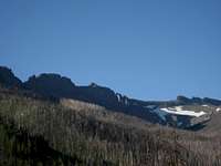 Blackwater Natural Bridge (view original size for more detail)
From here, the trail gradually leaves the creek behind and starts climbing up Clayton Mountain. Near the spot where the switchbacks begin, you are treated to a fantastic view of the massive walls of Double Mountain to the south and the Blackwater Natural Bridge, a huge keyhole arch that is located along the ridge to the right of Double. At this point, you are given your first look at the steep and rocky east face of Clayton Mountain, and the knowledge that the summit is still over 2,000 feet above you is daunting. About 2.5 miles after crossing the creek, you will reach the first fire memorial, which marks the place where eight men, including Alfred Clayton, lost their lives after being trapped in a nearby gulch while fighting the 1937 fire. Higher up on the trail, there is a second fire memorial at Post Point marking the place where seven other firefighters perished or suffered fatal injuries.
Above the second memorial, the trail becomes steeper and more rugged as it traverses across Clayton's west face. According to Bill Hunger's Hiking Wyoming book, the Forest Service does not maintain this part of the trail any more due to budget cutbacks and bear activity; however, in July of 2009, there were flagged stakes indicating sections to be repaired for about a quarter of a mile past the memorial. This includes some very bad washout sections and areas where rockfall has buried the trail. After a couple of more switchbacks, you will find yourself on the saddle between Clayton and Double Mountains with the huge Elk's Fork Valley open before you backed by the length of the 12,000+ foot high Wapiti Ridge.
 Summit
 View east towards Buffalo Bill Reservoir
From here, the trail skirts along Clayton's south face, crossing several talus slopes, finally reaching a small green meadow southeast of the summit. The trail briefly disappears but is quickly found again in the trees to the left, and it continues to the top, which includes a benchmark, a sign, and a small radio tower, which is maintained by helicopter. From the summit, you can see many peaks in Yellowstone Park, as well as long stretches of both the North and Southwest Absaroka Ranges. It is well worth taking a look at some of the exposure looking straight down the east face!
Climbing Clayton Mountain entails a round trip hike on a Class 1 trail of approximately 14-15 miles and 4,000 feet of elevation gain.
 Wapiti Ridge
 Summit cliffs
 View NW over the Shoshone National Forest
The 1937 Blackwater Fire
 Aerial view of the 1937 Blackwater Fire
On August 18, 1937, lightning sparked a fire in the Blackwater Creek drainage on the west slopes of Clayton Mountain. After burning in the undergrowth for two days, it was spotted by owners of a hunting camp and a plane that was observing another fire nearby. After it was reported to the Wapiti Ranger Station, a small group of CCC (Civilian Conservation Corps) members began working on constructing a fire line; throughout the afternoon and evening of the 20th, the number of firefighters fighting the blaze, now 200 acres, grew to about seventy. The Shoshone Forest supervisor, John Sieker, left the fire that evening to muster more men, and CCC camps from Tensleep in the Big Horns and the town of Deaver were called in. Fire crews worked through the night, and by early afternoon on the 21st, over 200 men were working on containing the fire.
 Clayton Gulch
Ranger Alfred Clayton was in charge of the eastern part of the fire line; a little after 3:00, he spotted some smoke on the wrong side of the fire line and sent a note to a fellow ranger, Urban Post, saying, "Post, we are on the ridge in back of you and I am going down to the spot in the hole. It looks like it can carry on over the ridge east and north of you. If you can send any men, please do so, since there are only eight of us. Clayton." At about 3:30, the wind suddenly picked up and began erratically shifting directions, which whipped the fire in the treetops into a frenzy. By the time Clayton's call for help reached Post, there was no way to respond, as the 45 mph gusts had surrounded Clayton and his men with flames. The forty men with Post abandoned the fireline and were able to escape to the northeast to a higher place on the mountain with fewer trees. Here they were completely surrounded by the flames and were forced to the ground by the intense heat, which literally started cooking their skin; four men perished when they panicked and tried to run through the fire to get out.
By about 5:00, the worst of the fire was over, and the survivors gradually made their way down through the smoke. Seven of Post's men died, and Clayton and six of the men with him died in a gulch where they apparently tried to take cover. One of his men, Roy Bevens, survived briefly but died of his burn injuries at the hospital in Cody. 500 men eventually brought the fire under control by the 24th of August, and it was out by the end of the month.
On the second anniversary of the tragedy, three monuments were dedicated in the memory of the men who died in the fire.
Source: http://forestarmy.blogspot.com/2007/08/death-on-fire-line-blackwater-fire-of.html
 Fire Fighters Memorial
The first memorial sits along the highway next to the turnoff to Blackwater Creek Ranch. All fifteen men who died in the fire are listed, and a plaque reads:
Shoshone National Forest Blackwater Fire August 20-24, 1937 This marks the beginning of the fire fighters' memorial trail which follows Blackwater Creek five miles to the place of origin of the fire, and thence to other points of interest. This fire was controlled after burning over 1254 acres of forest. Fifteen fire fighters lost their lives and thirty nine were injured when the fire was whipped up by a sudden gale on August 21. Signs and monuments mark the important locations along this trail, including the fire camps, the first aid station, Clayton Gulch where eight men were killed, and the rocky knoll where Ranger Post gathered the crew to escape the fire.
 Blackwater Fire Memorial
The second memorial marks the place where Ranger Clayton and seven other men lost their lives and is located at an elevation of 8330 feet right next to Clayton Gulch. It reads:
They gave their last full measure of devotion -- On the afternoon of August 21, 1937, while fighting the Blackwater Fire, these brave men lost their lives in the gulch to the right of this marker.
Alfred G. Clayton
Rex A. Hale
George E. Rodgers
Mack T. Mayabb
Will C. Griffith
John B. Gerdes
Roy Bevens
James T. Saban
 Post Point Memorial
The third memorial sits at 9020 feet and marks the place where Ranger Post brought his men. It reads:
Post Point -- Blackwater Fire -- August 20-24, 1937 Here, on the afternoon of August 21, 1937, thirty seven enrollees of CCC company 1811 in charge of Ranger Post and Jr. Forester Tyrell, with seven Bureau of Public Roads employees including Foreman Cooper and Fire Cooperator Sullivan in charge, took refuge from the fire. Five men attempted to escape through the fire and four of them - Lea, Allen, Seelke, and Sherry, perished. Ranger Post and all of the forty who remained with him received burns of varying severity and three of these - Jr. Forester Tyrell and enrollees Whitlock and Garza died later.
Red Tape
There are no fees or permits required to hike the Fire Memorial Trail. As much of this hike takes place in the forest on a trail with limited visibility, be extra cautious in looking out for wildlife. This area boasts one of the most dense populations of grizzly bears in the entire U.S., and black bears, moose, and mountain lions can present danger to hikers as well. At one point, my hiking partners and I found ourselves within 20 yards of a cow moose and her calf; thankfully, they ran away from us, as moose can get ugly when they are mad. I would not even consider hiking this trail alone or without an ample supply of bear spray!Camping
There are three campgrounds within a couple of miles of the Blackwater Creek Ranch, and all are situated near the road along the Shoshone River.Rex Hale Campground
Clearwater Campground
Newton Creek Campground
External Links
Blackwater Creek RanchForest Army Blog
Remembering the Dead of Blackwater
Fire Leadership Site