

-
 14521 Hits
-
 86.37% Score
-
 22 Votes
|
|
Mountain/Rock |
|---|---|
|
|
47.99664°N / 112.74342°W |
|
|
Mountaineering, Scrambling |
|
|
Summer |
|
|
8090 ft / 2466 m |
|
|
 The three summits of Mount Werner from the north.
The named summit is on the left.
Overview
Mount Werner is a massive, triple peaked mountain that divides the Muddy Creek and Blackleaf Creek drainages. While the routes are non-technical, this is still a long and rugged outing that affords wonderful views of the Rocky Mountain Front Range and the Bob Marshall Wilderness. Interestingly enough, the named summit on the east end of the ridge is, according to the USGS map, one foot lower than the unnamed West Summit. Since Werner forms the south side of the Blackleaf drainage and Mount Frazier forms the north side, both mountains are accessed from the Blackleaf Canyon Trailhead and can be each climbed in an easy day from there. Old Man of the Hills can be climbed from here as well, but it would be a very long day. With good camping nearby, this area offers several days worth of things to do.Getting There
Drive to Bynum on Montana State Highway 200. Bynum is about 15 miles north of Choteau. Just north of the dinosaur museum is Blackleaf Creek road, which turns sharply north after a few blocks, passing the Bynum School, and then after a few more blocks turns east again. This road is also signed as the way to Bynum Reservoir. After about 10 miles, the road to the reservoir splits off to the left. Blackleaf Creek road continues west and eventually crosses into the Blackleaf Wildlife Reserve. After a few miles, USFS land is entered. While the road is excellent gravel, suitable for any passenger car, the last half mile is somewhat rough, but still be passable by car. The only problem may be fording the creek, if it is running high. Blackleaf Trailhead
The trailhead is spacious with ample parking and has an outhouse.
The Blackleaf Canyon is worth the drive, even if you do not plan to hike or climb: huge vertical limestone walls arch above the trailhead. There are a number of climbing routes on these walls with many routes still to be developed. Details of the routes can be found in Central Montana Rock by Jake Mergenthaler.
From the trailhead, Blackleaf Trail #106 heads west through the gorge the creek has cut and continues up through a wide basin that alternates between low growing aspen and pine groves and meadows. This part of the basin is being grazed by cattle. The various routes (known and possible) for the most part leave from this trail.
Camping
There is an excellent campsite just about exactly the required 200 feet from the trailhead to the east. There are also several good camping spots along the road to the east between the last cattle guard and where the road starts down to the trail head. You can camp anywhere along the road in this area, but you must keep your vehicle within 300 feet of the road.Camping is possible in Blackleaf basin and we did see at least one established campsite. However, be aware that cattle are being grazed in the basin much of the year.
The mouth of Blackleaf Canyon is infamous for its occasional fierce wind. Hope that it isn’t blowing when you are there, but be prepared.
Choteau , about 1.5 hours from the Blackleaf TH, is the closest town with any amenities, lodging, gas, supplies, etc.
Routes
West Ridge - Summit Ridge Route: Class 2 and 3 Blackleaf/Teton Pass
 West Summit
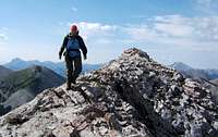
The summit ridge that crosses all three summits is a long and very beautiful journey above timberline. The route starts at the pass between the Blackleaf and Teton drainages, about 4 miles and 1500 feet elevation gain from the TH. Follow the western slopes over meadows and scree slopes to the rocky west ridge that leads to the first summit. Descend this summit on its east ridge and traverse over to the second summit.
 Middle Summit Middle Summit |
 Middle Summit Middle Summit |
 Looking back over the summit ridge of Mount Werner Looking back over the summit ridge of Mount Werner |
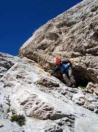
The second summit is the rockiest and most exposed of the three, but nowhere harder than class 3.
 Descent of the Middle Summit
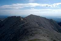 Traverse from the west
The northern scree slopes to the notches between the summits look feasible as does the north ridge to the second summit, but are probably better to use for a descent.
Descent Routes
1) Go back the way you came – surest bet.
2) Descend from the notches between the summits – looks feasible and there are some game trails. You’ll have to bushwhack through the forests at the base and across Blackleaf Creek to reach Trail 106. Since afternoon thunderstorms often build (and do so quickly), these options may prove handy if you need to go down in a hurry.
 The descent slope from the notch
3) Descend into Muddy Creek.
We did this. Overall this is a nice way to go BUT ONLY if the creeks are running low – otherwise this could be a real adventure. The only reason we went this way is that the slope down to the creek was short and not very steep and both the USFS and USGS maps showed a trail in the drainage. If there ever was a trail, it’s long gone. We ended up having to scramble down the steep creek bottom for about 1 mile. Considering how smoothly worn the big boulders were, this creek runs a lot of water at times. Should Muddy Creek be running full, you would have to stay high up the slope on the north side of the creek and traverse around the mountain – sure to be unpleasant and slow, but it isn’t very far. You eventually intersect with Trail 153. Finding this intersection is a bit tricky. Keep eyes open for a hunter’s camp near the creek’s edge. Go to the north side of the creek and walk east to find a large meadow that has some equipment from old oil and gas development activities. The trail is a few hundred feet west and slightly north from this machinery. Studying the map and setting some GPS waypoints will help as well. Trail 153 leads you back to Blackleaf Trail 106 in about 2 miles and from there it is just under a mile to the trailhead.
 Waterfalls in Muddy Creek Waterfalls in Muddy Creek |
 Muddy? Creek Muddy? Creek |
 Trail Junction Trail Junction |
Red Tape
None - Montana still believes in true freedom of the hills!Issues and Hazards
 Fossil Coral
- This is Grizzly Bear country - use appropriate precautions when traveling and camping!
- There is open grazing in the basin - so don't let the big black cows startle you too badly!
- Wind and sudden thunderstorms are typical of this area. Keep an eye out and take appropriate action sooner than later.
Hiking/Climbing Guide
This book is a valuable asset to anyone planning to spend much time in the Rocky Mountain Front. It also includes very brief descriptions of how to climb many of the major peaks.Discover The Rocky Mountain Front A Hiking Guide by Tom Kotynski