
-
 14002 Hits
-
 86.37% Score
-
 22 Votes
|
|
Mountain/Rock |
|---|---|
|
|
49.68423°N / 125.43252°W |
|
|
Mountaineering, Scrambling |
|
|
Spring, Summer, Fall |
|
|
6480 ft / 1975 m |
|
|
Overview
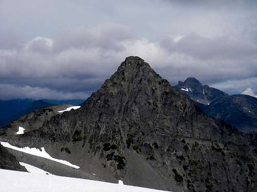 Mt Regan SE aspect Mt Regan SE aspect |
The route up Mt Regan has wonderful alpine character and offers all the aspects of a superb all-round mountaineering experience for those up to the challenge. Exposed scrambling, a glacier crossing and tricky route finding on loose rock on the summit block all await those willing to sample Mt Regan’s charms. And, as a bonus, and in spite of the fact that Albert Edward seems to tower over its summit, Regan ranks 22nd on the Island altitude list (Albert Edward is 6th).
Mt Regan forms part of a group of mountains in the eastern sector of Strathcona Provincial Park, Vancouver Island, that overlooks the west side of Forbidden Plateau and is separated from neighbouring ranges by the Eric Creek and Oyster River drainages to the south and west respectively. The passage of the glaciers in this part of the Island left most summits unscarred. The result is a relative rarity in Strathcona, a series of easy hiking peaks. As well as Albert Edward, pretty well hands-free routes are the order of the day on Jutland Mountain, Mt Frink and Castlecrag Mountain. There’s always an exception to every rule, however, and, in this case it’s Mt Regan. Steep on all sides with abundant rockfall down the many gullies that scar its flanks, Regan will be the last of the group that folk add to their climbing CV’s. In fact most never will.
Mt Regan acquired its name from a CPR surveyor during the extensive surveys of the area in the 1920's. Rather than being one of the dedicated outdoor types that normally undertake such jobs for the pure love of it, Mr Regan was in it purely for the money. The CPR had acquired title to the Forbidden Plateau area by virtue of its acquisition of the Esquimalt and Nanaimo Railway - the original landowner - and Regan was out there to assess the economic viability of the CPR's new land.
Reputedly a cigar-smoking drunk and a braggart, Regan had as little in common with his fellow surveyors as his namesake mountain does with its neighbours. In fact it was at Regan's insistence that the mountain was named after him.
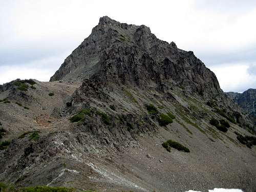
Mt Regan S aspect
Getting There
Vancouver Island can be reached directly by air from Toronto, Vancouver, Seattle, Calgary, Edmonton and recently from San Francisco to either Victoria, Nanaimo, Comox or Campbell River and by ferry from Port Angeles to Victoria on The Coho and on BC Ferries from Vancouver to Victoria or Nanaimo. Public transport on the Island is notoriously poor and anyone arriving by air would be advised to rent a car. Access in this case is all on paved roads and, therefore, fine with a normal sedan.Approach from north or south on the inland Island Highway 19. Near Courtenay take the Strathcona Parkway exit west to Mount Washington Alpine Resort. Drive up 20km and just before reaching the resort make a left turn onto Henry Road, following Parks signs for Paradise Meadows. Pass the bottom of the ski lifts after 1.5km and drive a further 0.5km to the end of the paved road at the cross-country facility Raven Lodge.
Parks have established a new trailhead and information booth right beside the lodge. If you get back from your trip before 5.30 pm, the Raven Lodge has a lovely view over to the mountains and is a great place for the beer you so rightfully deserve!
Approach
Although other approaches and routes to the summit of Mt Regan exist I will only report on what I have actually done and, therefore, what “goes”. I do, however, include a synopsis under “Other Routes” (below) and ask that readers who have done these add details and photos using the “add route” facility.The approach to Mt Regan from Paradise Meadows takes the climber to within 300 metres map distance and 100 metres of relief from the summit of Mt Albert Edward. Details of the approach, therefore, are almost exactly those for climbing Albert Edward. You are starting, in fact, from a point higher than the summit of Regan!
Complete the formalities at the trailhead (see below) and head out across the groomed trail and boardwalk onto Paradise Meadows. Reference to this map illustrates the possible routes to Circlet Lake from where you start to gain real elevation. I recommend the route via Helen Mackenzie and Hairtrigger Lakes. This brings you in 2-4 hours, depending on your pack weight, to a marked trail junction for the campground at Circlet Lake. If you are staying here the night, turn right and along the shore of a small unnamed lake before dropping down slightly into the bowl that holds Circlet. Otherwise, head straight on across the head of the small lake and up the trail.
Five minutes up the trail watch for an old Comox and District Mountaineering Club (CDMC) wooden sign mounted high on a tree and indicating the way to Moat Lake. Carry straight on for Albert Edward (and Regan).
The route now steepens considerably as it winds its way up and to the right of a large bluff, crosses a rubble or snow-filled gully and ascends a final steep gully to a flat tarn-studded alpine plateau underneath the NE ridge of Albert Edward. Cross the plateau and then go up one more steep bit before arriving on the ridge itself. This is a trail junction of sorts and is marked by a very large cairn. The trail by this point has become more of a booted-in route but it’s well marked with cairns and where you have to go is very obvious. At the large cairn you are presented with a stunning vista of the whole northeast facing shallow cirque below the upper part of Albert Edward’s NE ridge. To your right the ridge runs round north and west and up Jutland Mountain. On the other side of the drainage and connected to Albert Edward by a narrow ridge and col is your objective. Take note of the position of the highest remnant snowfield just below the summit of Albert Edward.
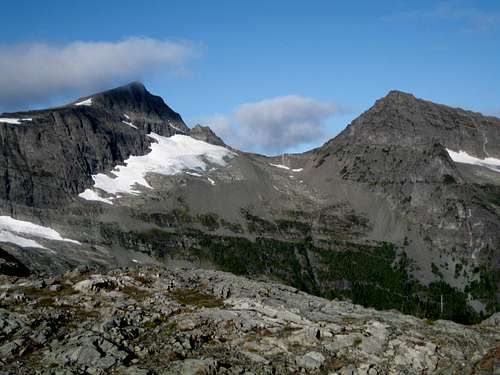 Mts Albert Edward & Regan | 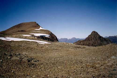 Approaching the summit route I | 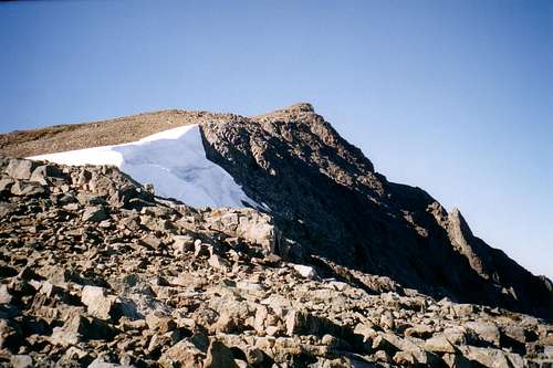 Approaching the summit route II |
From the cairn, walk up the ridge with views down to Moat Lake on your left. The ridge eventually turns right and northwest and broadens as it heads for the summit of Albert Edward. The immediate terrain is rather featureless at this point and if visibility is questionable, this is the place to make a few notations on the map, or waypoints on the GPS.
Walk up towards the summit of Albert Edward following cairns and, when you estimate that you’re about 500 metres distance below the summit, traverse off to the north to N49 40.664 W125 25.604. You should be right underneath the snow patch noted above and looking down on the east glacier below.
Walk up towards the summit of Albert Edward following cairns and, when you estimate that you’re about 500 metres distance below the summit, traverse off to the north to N49 40.664 W125 25.604. You should be right underneath the snow patch noted above and looking down on the east glacier below.
Summit Route
Rock fall hazard will be a real possibility on this route and helmets should be worn from the start.
Descent route
From the position on the ridge described above look for a series of ledges going down to the northwest. The route goes under the snow patch and lies almost directly along a line encompassing the drop-off point from the ridge and the low point of the Albert Edward/Regan col. Once over this initial section, the exposure lessens, the angle below eases and series of grass and scree slopes reveal themselves angling down to the glacier.
Head down some 100 metres of relief continuing to aim for the col until forced into a more northerly course as bluffs close in above and below.
Finally approach the snow down a narrow but solid rock tongue which takes you at Class 3/4 down to the glacier to N49 40.745 W125 25.757, right opposite – but thankfully below – a major bergschrund.
 Upper descent route Upper descent route |  Descending the glacier Descending the glacier |  At the base of the glacier At the base of the glacier |  Returning to Albert Edward Returning to Albert Edward |
Climb the moraine and then follow the crest as it swings left before meeting the Albert Edward/Regan col at its west end.
 Descent & climbing route Descent & climbing route | 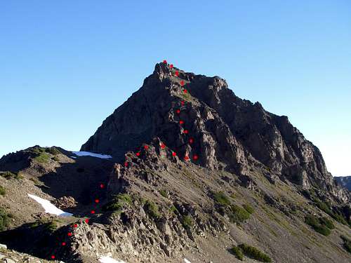 Climbing route Climbing route |
From the col proceed north towards Mt Regan’s south ridge. A wide, loose gully heads up towards a headwall above. Follow the gully for about 300 metres before deeking off right and up to a black ridge. Follow this ridge up to where it meets the east side of the headwall. A number of gullies provide potential passage through this section and we spent an hour or more looking at several possibilities before settling on one at N49 41.033 W125 25.907. This is an in situ waypoint not one added later from the tracklog. You can rely on it. As you approach the headwall from the black ridge, it’s the second gully on the right. The first gully has an undercut overhanging base.
 Albert Edward/Regan col Albert Edward/Regan col |  Lower south ridge Lower south ridge |  Upper south ridge Upper south ridge |  Stepping on to the summit Stepping on to the summit |
Climb the gully (~ 15 m) at Class 3 to easy but loose ground above. Thereafter head due north with some easy scrambling to the summit ridge. Turn left and walk 10 metres to the satisfyingly airy summit - about 10 minutes climbing time above the gully.
The small summit just about accommodates a cairn big enough to hold the new (August 2008) Alpine Club of Canada summit register. There are 5 entries to date, one of which claims the summit in 5.25 hours from the Raven Lodge!
Views from the summit of Regan tend to be dominated by what is close to hand. Albert Edward, of course, but also across the deep valley to the west are the summits on the far side of the Oyster River. Sid Watts Peak, Augerpoint Mountain, Mt Mitchell and, further north, Alexandra Peak. To the NE is Jutland Mountain with Gem Lake below.

Mt Regan route profile
Some route stats:
TH to Circlet Lake ~11.5 km
Circlet to Regan summit and return ~ 16 km
Net elevation TH to Circlet ~ 50 metres
Total elevation TH to Circlet ~ 350 metres
Net elevation Circlet to Regan summit ~ 825 metres
Total elevation Circlet to Regan summit and return ~ 1,400 metres
A MapSource/Garmin tracklog is available for the asking for the approach and summit routes. Just send me an email or PM.

On the summit of Mt Regan
Other Routes
The Albert Edward/Regan col has also been reached by dropping off the approach ridge down a convenient gully at N49 40.951 W125 24.049 and traversing the whole NE cirque of Albert Edward below the glacier and up to the col.Alternatively, the same col can be reached from Gem Lake up the steep cirque at the head of the lake to the glacier and thence to the col. Gem Lake is reached by hiking SE out of the Oyster River valley on the Gem Lake Trail.
 Alternate descent point Alternate descent point |  Alternate route view Alternate route view |  Gem Lake approach option Gem Lake approach option |
Red Tape & Safety Considerations
If you camp at Circlet Lake, or anywhere else in the designated core area of Strathcona Park, there is a $5/person/day fee. There is a self-registration box and payment slot at every core designated trailhead. Payment can be by cash or cheque. Fill in the payment form before you leave and take the receipt slip with you.At any time there is line-of-sight to the cellular repeater tower on nearby Mt Washington you will have service.
Camping
Choosing the correct camp on the route described above can be critical in minimizing the effort and maximizing the enjoyment required to reach Mt Regan.Up to and including the summit of Regan you are in a “core area” of Strathcona Park where you must camp only in the designated areas. In the present example this means at Circlet Lake. However, ease of access to Circlet has resulted in a lot of folk who think reality TV shows are about real life, making this their adventure of a lifetime. This is the place to see grandad’s old army frame pack (with machete and frying pan strapped to the outside of course) camouflage clothing, jeans etc. Such folk, however, don’t seem to be able to confine their sense of the inappropriate to just inadequate equipment. Dogs running wild, littering, late night partying and worse are to be expected. In fact it’s often referred to as “Circus Lake”. There are, however, other possibilities.
The core area rules were set somewhat arbitrarily with the principle aim of protecting the most frequented and delicate areas of Strathcona. In practice, and as someone with an out-of-the-ordinary objective, no-one is going to hassle you if you camp outside the regulated areas provided you practice strict no-trace methods and keep a low profile. With this is mind it is eminently possible to camp on the plateau below the NE ridge between Albert Edward and Jutland Mountain or even on the ridge itself.
Wherever you choose to camp, note that fires are strictly prohibited, so you must pack a stove. Bear and cougar frequent the mountains and forests of Vancouver Island, so proper back country methods – hanging food bags out of reach, cleaning up all cooking scraps, good toilet practice etc – are essential. Giardia is well documented throughout Strathcona Park, so boil or treat all water.
Useful Links
Strathcona Provincial ParkAdditional Information/Suggested Reading
Beyond Nootka – A Historical Perspective of Vancouver Island Mountains, Lindsay Elms, Misthorn Press, 1996, ISBN 0-919537-29-4 and/or visit Beyond Nootka
Island Alpine – A Guide to The Mountains of Strathcona Park and Vancouver Island, Philip Stone, Wild Isle Publications, 2003, ISBN 0-9680766-5-3 and/or visit Island Alpine Climbing Guide
Weather
Nearest point current conditions and forecast.OR
Check the weather at altitude right from Mt Washington’s webcam
