
-
 8309 Hits
-
 82.48% Score
-
 15 Votes
|
|
Mountain/Rock |
|---|---|
|
|
44.58340°N / 109.5497°W |
|
|
Park |
|
|
Hiking, Mountaineering, Scrambling |
|
|
Summer, Fall |
|
|
12132 ft / 3698 m |
|
|
Overview
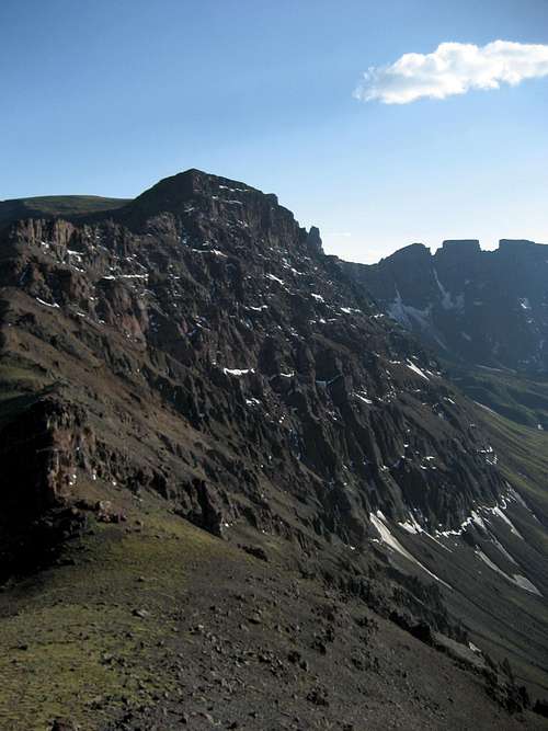 The north face of Crag Peak
Anyone who ventures onto the high plateaus in the remote reaches of the North Absaroka Wilderness is likely to find solitude that is rarely matched outside of the lesser known ranges of the Greater Yellowstone Ecosystem; few hikers and climbers travel to the summits in this area due to the long approaches, large and active grizzly bear populations, and lack of established trails on the mountains. For most people, Crag Peak is not a mountain that is a climbing destination by itself, as almost anyone who travels far enough to reach its summit will travel the extra couple of miles to Trout Peak, the highest mountain in the Northern Absaroka Range. However, anyone who bypasses this summit on their way to Trout Peak is missing out on some spectacular views, including the drainage to the northwest and the rugged wall of pinnacles that border it on the south.
This peak has 672 feet of prominence, and its elevation of 12,132 feet makes it the 178th-ranked mountain in Wyoming. As with many of the remote peaks in the state, this one has no official name; for the purposes of this page, I am calling it Crag Peak after the Crag Benchmark, located on the summit plateau one half mile southeast of the top at 12,051 feet, which is just slightly lower than the summit.
Elevation and prominence numbers from www.listsofjohn.com.
Summit Views
From the top of Crag Peak, most of your attention will be drawn west, as the view east consists of a large, gently sloping alpine plateau. The two large pinnacles on the ridge to the west both rise above 12,000 feet, and their vertical sides and inaccessibility combined with the fact that they are made up of rotten Absaroka breccia make it likely that they are unclimbed. Much of the Southwest Absaroka Range is visible to the south, including Wapiti Ridge, the highest peak in the range. Summit view west to the ridge pinnacles
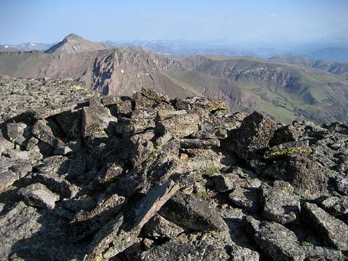 Summit view north to Mount Dewey
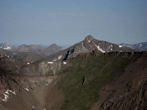 Dead Indian Peak
 Summit view south to the Southwest Absarokas
 Trout Peak (left) and Robbers Roost (right)
Getting There
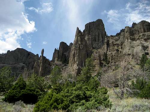 Rock Pinnacles at the base of Jim Mountain
(Note: This approach information is the same as for the Jim Creek Approach to Trout Peak.)
The Jim Creek Trailhead is located near the town of Wapiti, Wyoming, and accesses the Shoshone National Forest and the North Absaroka Wilderness from the south. Travel west from Cody, Wyoming on Highway 16 for 18 miles. Turn right on County Road 6GV and stay on the main 2.5 miles, keeping left at the fork. At the point where the county road ends, there is a short section of road that requires high clearance and 4WD before the final half mile to a closed gate that enters the trailhead parking area and the National Forest.
Hike to the trees on the trail through the sage brush and begin ascending the Jim Creek drainage. Stay left at the fork; after several miles, the forest begins to show signs of the Gunbarrel fire of 2008, and by the time you reach the waterfall, you are passing through nothing but dead trees. After four easy stream crossings, the trail leaves the forest and enters the enormous meadows north of Jim Mountain.
 Jim Mountain meadows
 Rock formations on Crag Peak
After the trail fades, continue to the top of the meadow and look for a game trail that descends into the drainage that contains the East Fork of Big Creek. This gigantic bowl is bordered on either side by spectacular cliffs and is full of wildflowers in the summer; there is no sign of human presence, and in fact, no established trails enter this valley from any side. Follow the creek to its headwaters and ascend the headwall at the end of the valley, keeping to the right of the large glacier as you make your way up.
After reaching the plateau above 11,000 feet, the views become stunning as Trout Peak and Robbers Roost finally become visible away to the north. Head northwest to the narrow ridge that reaches over to Peak 12,132, crossing two easy notches on the ridge before you reach the plateau with the benchmark at 12,051 marked "Crag" on the topo map. From here, stay in the middle of the plateau and head northwest to the summit, which overlooks some fantastic steep cliffs that plummet over 1500 feet down into the valley below.
 Jim Creek route 1
 Jim Creek route 2
The total distance for the Jim Creek approach to Crag Peak is 10.5 miles one way on Class 1 and Class 2 terrain with over 6,200 feet of total elevation gain.
 Jim Creek waterfall
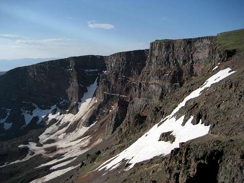 Walls and glaciers on Crag Peak
 East Fork Big Creek drainage
 Looking straight down from the summit
Red Tape
There are no access fees for the Shoshone National Forest or the North Absaroka Wilderness. The roads to the Jim Creek TH and Spout Springs both have easements across private property, so be sure to stay on the road until you pass the forest boundary on either road. Read this page for more information regarding rules and regulations in the North Absaroka Wilderness.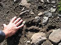 Grizzly tracks at 12,000 feet on Crag Peak
This area has one of the most dense populations of grizzly bears found anywhere, and if you make this climb without seeing dozens of tracks and overturned rocks, you probably weren't looking hard enough! These bears go everywhere, including very high up; some of the tracks I saw were above 12,000 feet. Be sure to carry bear spray, and carrying an extra can might be a wise idea. Proper food storage rules apply to overnight stays in the Wilderness.
Camping
Camping is not allowed within 50 feet of established trails in the North Absaroka Wilderness. There are generally a few snowbanks that linger throughout the year on Trout Peak that can be used as water sources, but be aware that if these are gone in the late summer, you may be thousands of feet above the nearest water source. Bring bear containers or rope to suspend your food off of rock ledges during the night; always practice Leave No Trace ethics when hiking and camping in this area.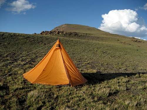 Camping on nearby Trout Peak
External Links
Information on the North Absaroka Wilderness:Wilderness.net
GORP site
Wikipedia
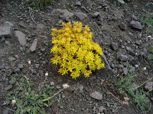 Wildflowers on Jim Mountain