
|
|
Mountain/Rock |
|---|---|
|
|
48.69444°N / 121.04291°W |
|
|
Whatcom |
|
|
Hiking, Mountaineering |
|
|
Spring, Summer, Fall, Winter |
|
|
7408 ft / 2258 m |
|
|
Overview
Ruby Mountain, also known by some people and resources as Ruby Peak, is a significant mountain in the North Cascades region of Washington. Perhaps most notably to peakbaggers, with 3888' of clean prominence Ruby Mountain is the 21st-most prominent peak in Washington. Ruby Mountain is also notable for having the seasonal closure gate for Highway 20 (i.e. North Cascades Highway) on its north side. Ruby Mountain has also long been known as having an open summit with far-ranging 360-degree views of other peaks in the North Cascades. North Side Of Ruby Mountain
One other interesting, yet seldom realized, aspect of Ruby Mountain is that the peak is almost an island. The mountain is bordered by Ross Lake on its north side, Diablo Lake and Thunder Creek on its west side, Thunder Creek on its southwest side, and Panther Creek on its east side and southeast side. When including minor streams flowing from Fourth of July Pass (on the south side of the mountain), Ruby Mountain just barely avoids being an island by only approximately 0.5 miles (i.e along Fourth of July Pass). To be almost completely surrounded by water is an oddity for most peaks in the Cascade Mountains.
 Looking At Ruby Mountain Summit...
Ruby Mountain is also historically significant. The mountain was first summited in 1916 by local climber Tommy Thompson (for whom a peak in neighboring Skagit County was named after). An unofficial steep and rugged trail, nicknamed the Ruby Mountain Trail, has been leading from Fourth of July Pass to the summit for many years. Although the route is unofficially recognized by both the U.S. Forest Service and North Cascades National Park, the culmination of its popularity with the peak's convenient central location in the North Cascades led to a plan in the 1960s and early 1970s to build an aerial tramway to the mountain summit. However, due to high project costs and political issues, the tramway plan was eliminated by the mid-1970s.
 Southwest View From True Summit...
With the tramway idea gone, focus began to be set on the existing unofficial Ruby Mountain Trail. During the 1980s, plans were being created to rebuild the Ruby Mountain Trail (over the existing trail) and make it a low-maintenance hiker-only trail. However, due to concerns about possible impacts to plants, wilderness, and wildlife as a result of the trail reconstruction project, that plan, too, was eliminated. After the trail reconstruction plan ended, the Ruby Mountain Trail was officially declared, and signed, as an unmaintained trail. However, the original unofficial Ruby Mountain Trail still exists today, although increasingly overgrown in multiple places along its route and its trail junction with Panther Creek Trail/Fourth of July Pass is unmarked.
 Hard-To-Follow Section of Ruby Mountain Trail...
Ruby Mountain can be climbed year-round. During summer and fall months, and during non-snow periods, the mountain is most commonly summited via the Ruby Mountain Trail that follows the south ridge from Fourth of July Pass. During winter and spring months, and during snow periods, the mountain is most commonly summited via the northwest ridge of the mountain starting from Highway 20. The Ruby Mountain Trail option can be done as one long day's hike, but many summiters might opt to have the summit trip as a part of a two-day trek. The northwest ridge option is typically only done as a long day's hike/snow-climb.
 Northwest Ridge...
Several tiny glaciers can be found/seen on the north side of the summit ridge. Appropriately named, Ruby Mountain is truly like a "gem" of the North Cascades.
 Summit Ridge, With Glaciers Alongside
Ruby Mountain was named after a mining town called Ruby City that existed in the late 1800s. The town became officially incorporated as just "Ruby" on September 1, 1890. The mining town was a hub for miners, trappers, hunters, and explorers seeking a supply point and shelter while traveling along the upper Skagit River. The settlement was located at the mouth of Ruby Creek, on the north side of Ruby Mountain, where the creek entered Ross Lake. Unfortunately, mining in the area eventually subsided and Ruby became a ghost town. Later, the Ross Lake Dam was built nearby and what few remnants remained of the town of Ruby have since ended up under water.
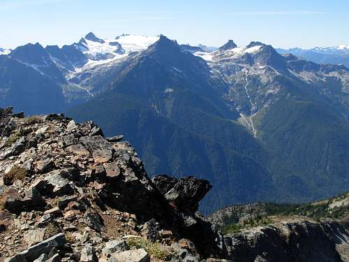
 Northern View From Summit
Getting There
ALL DIRECTIONS BEGIN FROM NEWHALEM, WA:
FOR SOUTH RIDGE/ RUBY MOUNTAIN TRAIL ASCENTS:
OPTION #1:
1) Drive approximately nine miles east along Highway 20 to Colonial Creek Campground. The Thunder Creek Trailhead (~1200' elevation) is located on the south side of the campground area.
2) Hike Thunder Creek Trail for 2.1 miles, to the trail junction (1400' elevation) with Panther Creek trail (leading towards Fourth of July Pass).
3) Hike Panther Creek Trail for approximately 3.2 miles, passing Fourth of July Camp and Panther Potholes along the way, until on the east side of Fourth of July Pass.
4) As soon as the first 30'-long bridge is seen, search for a hidden path (~3600' elevation) approximately 50' west of the bridge (on the north side of Panther Creek Trail). Once located, this path is the beginning of Ruby Mountain Trail. Within 100 yards along the trail, a sign is found that says "TRAIL ABANDONED - NO LONGER MAINTAINED".
 Warning Sign For Ruby Mountain Trail
5) Hike along Ruby Mountain Trail as best as possible to follow. If the trail seems to disappear or be covered-over and cannot be found again, continue heading due north up the south ridge, either following the ridgeline or just slightly west of the ridgeline (to avoid unwanted gullies and small cliff-faces). By following this method, and visitng open spots along the ridgeline while ascending, the original trail can likely be re-encountered again by 5000' elevation. If the trail is followed after that point, it is mostly straightforward trail-hiking until the slope leading to the summit ridge.
6) Once at the open, meadow slope (~6000'-6600' elevation) leading up to the summit ridge, steeply ascend to the most-open saddle of the ridge. Once on the summit ridge, turn left (northwest) and continue until reaching the true summit (7408' elevation).
NOTE: The true summit has an antenna/repeater station on it.
TOTAL ROUNDTRIP DISTANCE: Approximately 18-19 miles, with ~6200' elevation gain.
OPTION #2:
1) Drive approximately 16 miles east along Highway 20 to the East Bank Trailhead located on the northeast side of Ruby Mountain. The north side of the Panther Creek Trail begins (~1800' elevation) near this location.
2) Follow Panther Creek Trail for approximately 6.1 miles, until crossing a 30'-long bridge just prior to entering the Fourth of July Pass area.
 Important Bridge Along Panther Creek Trail...
3) As soon as the first 30'-long bridge is crossed, search for a hidden path (~3600' elevation) approximately 50' west of the bridge (on the north side of Panther Creek Trail). Once located, this path is the beginning of Ruby Mountain Trail. Within 100 yards along the trail, a sign is found that says "TRAIL ABANDONED - NO LONGER MAINTAINED".
4) Hike along Ruby Mountain Trail as best as possible to follow. If the trail seems to disappear or be covered-over and cannot be found again, continue heading due north up the south ridge, either following the ridgeline or just slightly west of the ridgeline (to avoid unwanted gullies and small cliff-faces). By following this method, and visitng open spots along the ridgeline while ascending, the original trail can likely be re-encountered again by 5000' elevation. If the trail is followed after that point, it is mostly straightforward trail-hiking until the slope leading to the summit ridge.
5) Once at the open, meadow slope (~6000'-6600' elevation) leading up to the summit ridge, steeply ascend to the most-open saddle of the ridge. Once on the summit ridge, turn left (northwest) and continue until reaching the true summit (7408' elevation).
NOTE: The true summit has an antenna/repeater station on it.
TOTAL ROUNDTRIP DISTANCE: Approximately 20-21 miles, with ~5600' elevation gain.
------------
FOR NORTHWEST RIDGE/ SNOWY ASCENTS:
1) Drive for approximately 12 miles east along Highway 20 to a small turnout (~1900' elevation). Park at one end of the turnout.
NOTE: The turnout is 2.8 miles northeast of Colonial Creek Campground, and 0.4 miles west of Horsetail Creek, along Highway 20. The turnout is located across the highway from a large boulder field on the north side of Ruby Mountain.
2) Steeply hike straight up the mountainside, starting left (east) of the large boulder field. Continue hiking straight up the hillside for approximately 450' elevation.
3) After ascending 450' elevation from the highway, begin angling left for the next 200' elevation until reaching the northwest ridgeline.
4) Follow the northwest ridge, crossing over Point 6315', until reaching the summit ridge. The final 300' elevation gain to attain the summit ridge and true summit requires scrambling.
NOTE: The true summit has an antenna/repeater station on it.
TOTAL ROUNDTRIP DISTANCE: Approximately seven miles, with ~5500' elevation gain.
Red Tape
Overnight stays require backcountry permits, which can be acquired from the North Cascades Wilderness Center located in Marblemount, WA.A Northwest Forest Pass (i.e. parking permit) is required to park at Thunder Creek Trailhead and East Bank Trailhead.
Side-Note From Ken Russell, August 2011: According to a ranger whom Ken spoke with at Colonial Creek Campground, no Northwest Forest Pass is required for the Thunder Creek Trailhead. However, this might only apply to day hikes. It is recommended to contact the North Cascades Wilderness Center (Marblemount, WA) prior to visiting, to verify current rules and regulations.
Ruby Mountain is commonly a location for many cougar and bear sightings. Take typical precautions, but it is recommended to contact one of the North Cascades National Park visitor centers prior to visiting the area for current updates, advice, etc.
Tampering with, damaging, entering, or destroying the antenna/repeater station at the summit of Ruby Mountain is strictly prohibited.
For specific rules and regulations regarding hiking to the summit of Ruby Mountain, please contact the North Cascades Wilderness Center in Marblemount, WA.
Camping
Colonial Creek Campground is both the closest and largest maintained campground near Ruby Mountain.However, several backcountry campsites are closer to the peak:
Fourth of July Camp
Thunder Camp
Panther Camp
Neve Camp
NOTE: An overnight/backcountry permit (free) is required for all overnight stays in the backcountry around Ruby Mountain. Overnight/backcountry permits can be obtained from the North Cascades Wilderness Center in Marblemount, WA.